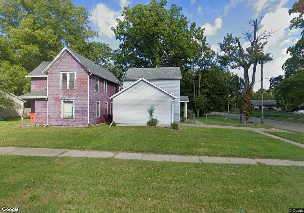
561 Edwards Ave Benton Harbor, MI 49022
Estimated Value: $115,000 - $172,000
3
Beds
2
Baths
1,152
Sq Ft
$126/Sq Ft
Est. Value
About This Home
This home is located at 561 Edwards Ave, Benton Harbor, MI 49022 and is currently estimated at $145,290, approximately $126 per square foot. 561 Edwards Ave is a home located in Berrien County with nearby schools including Fair Plain Middle School, Benton Harbor High School, and Benton Harbor Charter School Academy.
Ownership History
Date
Name
Owned For
Owner Type
Purchase Details
Closed on
Aug 12, 2004
Sold by
Community Housing Initiative
Bought by
Hill Betty
Current Estimated Value
Home Financials for this Owner
Home Financials are based on the most recent Mortgage that was taken out on this home.
Original Mortgage
$56,535
Outstanding Balance
$28,221
Interest Rate
6.1%
Mortgage Type
FHA
Estimated Equity
$117,069
Purchase Details
Closed on
Apr 22, 2002
Purchase Details
Closed on
Jun 3, 1985
Create a Home Valuation Report for This Property
The Home Valuation Report is an in-depth analysis detailing your home's value as well as a comparison with similar homes in the area
Home Values in the Area
Average Home Value in this Area
Purchase History
| Date | Buyer | Sale Price | Title Company |
|---|---|---|---|
| Hill Betty | -- | Meridian Title Corp | |
| -- | $100 | -- | |
| -- | -- | -- |
Source: Public Records
Mortgage History
| Date | Status | Borrower | Loan Amount |
|---|---|---|---|
| Open | Hill Betty | $56,535 | |
| Closed | Hill Betty | $20,000 |
Source: Public Records
Tax History Compared to Growth
Tax History
| Year | Tax Paid | Tax Assessment Tax Assessment Total Assessment is a certain percentage of the fair market value that is determined by local assessors to be the total taxable value of land and additions on the property. | Land | Improvement |
|---|---|---|---|---|
| 2025 | $1,753 | $58,800 | $0 | $0 |
| 2024 | $1,686 | $51,700 | $0 | $0 |
| 2023 | $1,349 | $37,500 | $0 | $0 |
| 2022 | $1,530 | $27,100 | $0 | $0 |
| 2021 | $1,540 | $26,400 | $700 | $25,700 |
| 2020 | $1,521 | $27,200 | $0 | $0 |
| 2019 | $1,494 | $23,900 | $0 | $0 |
| 2018 | $1,972 | $0 | $0 | $0 |
| 2017 | $1,972 | $44,800 | $0 | $0 |
| 2016 | $1,934 | $45,300 | $0 | $0 |
| 2015 | $1,929 | $43,600 | $0 | $0 |
| 2014 | $2,048 | $52,900 | $0 | $0 |
Source: Public Records
Map
Nearby Homes
- 470 N Mccord St
- 530 Rembert Ct
- 696 Highland Ave
- 6525 Territorial Rd
- 710 Buss Ave
- 309 High St
- 255 High St
- 238 Pine St
- 137 Cornelia St
- 992 Highland Ave
- 1069 E Main St
- 937 Hall St
- 391 Pipestone St
- 378 Pipestone St
- 234 Walnut St
- 419 Packard St
- 1226 Chicago Ave
- 416 E Britain Ave
- VL Eighth Ninth Boughton St
- 394 Linden St
- 555 Edwards Ave
- 3075 Edwards Ave
- 3169 Edwards Ave
- 547 Edwards Ave
- 579 Edwards Ave
- 364 N Stevens St
- 539 Edwards Ave
- 593 Edwards Ave
- 533 Edwards Ave
- 314 N Stevens St
- 550 Edwards Ave
- 380 N Stevens St
- 578 Edwards Ave
- 365 N Stevens St
- 538 Edwards Ave
- 363 N Hull Ave
- 525 Edwards Ave
- 584 Edwards Ave
- 601 Edwards Ave
- 373 N Stevens St