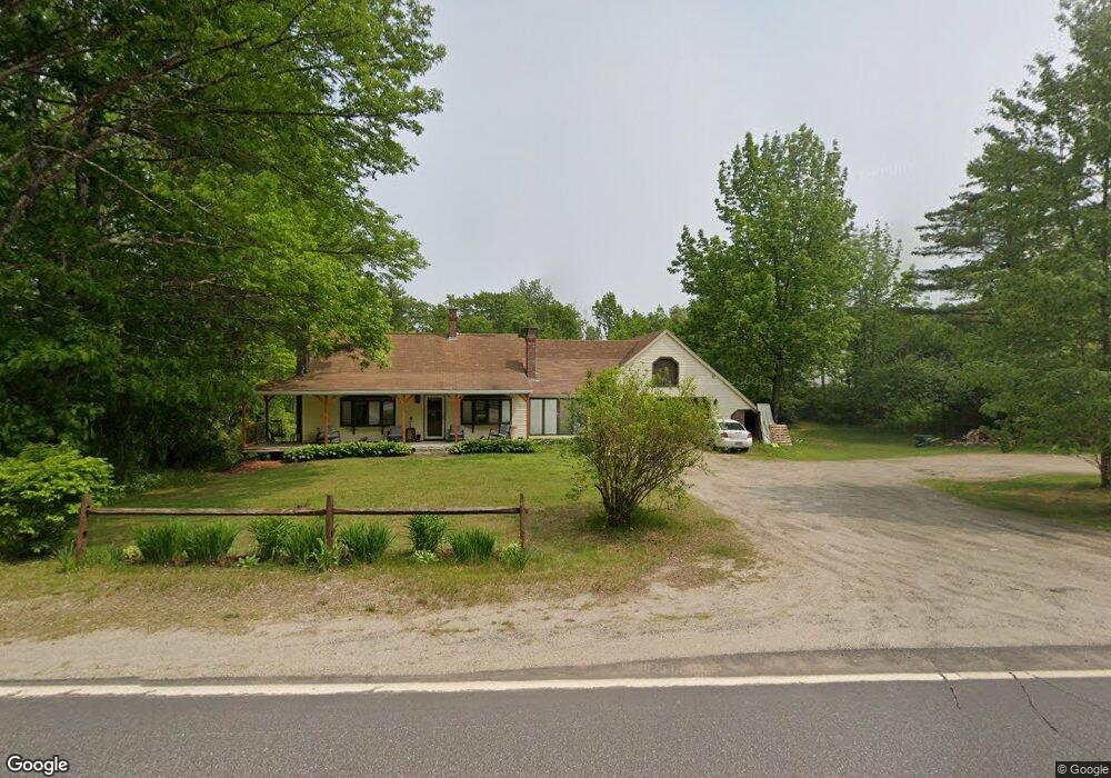
561 River Rd Bowdoinham, ME 04008
Estimated Value: $384,940 - $452,000
3
Beds
2
Baths
1,700
Sq Ft
$237/Sq Ft
Est. Value
About This Home
This home is located at 561 River Rd, Bowdoinham, ME 04008 and is currently estimated at $402,985, approximately $237 per square foot. 561 River Rd is a home located in Sagadahoc County with nearby schools including Mt Ararat High School.
Ownership History
Date
Name
Owned For
Owner Type
Purchase Details
Closed on
Dec 16, 2024
Sold by
Wagg Julie A
Bought by
Hanson Matthew B
Current Estimated Value
Home Financials for this Owner
Home Financials are based on the most recent Mortgage that was taken out on this home.
Original Mortgage
$136,000
Outstanding Balance
$134,312
Interest Rate
6.79%
Mortgage Type
Purchase Money Mortgage
Estimated Equity
$268,673
Purchase Details
Closed on
Jul 5, 2016
Sold by
Hanson Bruce A and Hanson Melody
Bought by
Hason Matthew B and Wagg Julie A
Home Financials for this Owner
Home Financials are based on the most recent Mortgage that was taken out on this home.
Original Mortgage
$160,000
Interest Rate
3.58%
Mortgage Type
New Conventional
Create a Home Valuation Report for This Property
The Home Valuation Report is an in-depth analysis detailing your home's value as well as a comparison with similar homes in the area
Home Values in the Area
Average Home Value in this Area
Purchase History
| Date | Buyer | Sale Price | Title Company |
|---|---|---|---|
| Hanson Matthew B | -- | None Available | |
| Hason Matthew B | -- | -- |
Source: Public Records
Mortgage History
| Date | Status | Borrower | Loan Amount |
|---|---|---|---|
| Open | Hanson Matthew B | $136,000 | |
| Previous Owner | Hason Matthew B | $160,000 |
Source: Public Records
Tax History
| Year | Tax Paid | Tax Assessment Tax Assessment Total Assessment is a certain percentage of the fair market value that is determined by local assessors to be the total taxable value of land and additions on the property. | Land | Improvement |
|---|---|---|---|---|
| 2025 | $5,618 | $254,100 | $73,900 | $180,200 |
| 2024 | $5,336 | $254,100 | $73,900 | $180,200 |
| 2023 | $4,955 | $254,100 | $73,900 | $180,200 |
| 2022 | $3,768 | $208,300 | $61,600 | $146,700 |
| 2021 | $3,535 | $208,300 | $61,600 | $146,700 |
| 2020 | $3,514 | $208,300 | $61,600 | $146,700 |
| 2019 | $3,431 | $208,300 | $61,600 | $146,700 |
| 2018 | $3,154 | $183,900 | $61,600 | $122,300 |
| 2017 | $3,099 | $183,900 | $61,600 | $122,300 |
| 2016 | $3,338 | $201,700 | $79,400 | $122,300 |
| 2015 | $3,318 | $201,700 | $79,400 | $122,300 |
| 2014 | $3,278 | $201,700 | $79,400 | $122,300 |
| 2013 | $3,126 | $203,000 | $79,400 | $123,600 |
Source: Public Records
Map
Nearby Homes
- 0 White Rd
- 83 Hemlock Hill Ln
- 1 Cairn Hill Rd
- 852 River Rd
- 00 Skillings Dr
- 79 S Pleasant St
- 25 Evergreen Ln
- 27 Evergreen Ln
- 467 Bay Rd
- 258 Dingley Rd
- 36.5 Acres Augusta Rd
- 1524 Augusta Rd
- 0 Dingley Rd
- 274 Front St
- 10 Overlook Dr
- 142 Deer Run Rd
- 64 Main St
- 14 Hedge Bridge Rd
- 1044 Middle Rd
- Lot 51E Morton Rd
Your Personal Tour Guide
Ask me questions while you tour the home.