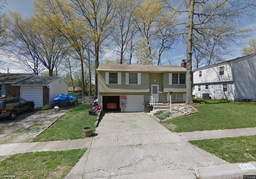
5615 Spohn Dr Westerville, OH 43081
Estimated Value: $285,000 - $301,000
3
Beds
2
Baths
1,338
Sq Ft
$218/Sq Ft
Est. Value
About This Home
This home is located at 5615 Spohn Dr, Westerville, OH 43081 and is currently estimated at $292,178, approximately $218 per square foot. 5615 Spohn Dr is a home located in Franklin County with nearby schools including Huber Ridge Elementary School, Walnut Springs Middle School, and Westerville Central High School.
Ownership History
Date
Name
Owned For
Owner Type
Purchase Details
Closed on
Apr 27, 2004
Sold by
Mckee Patricia and Estate Of Robert I Frederickso
Bought by
White John and White Lynn
Current Estimated Value
Purchase Details
Closed on
May 6, 2002
Sold by
Estate Of Loretta J Fredrickson
Bought by
Fredrickson Robert I
Purchase Details
Closed on
Oct 25, 2001
Sold by
Joanne Fredrickson Robert I and Joanne L
Bought by
Fredrickson Robert I and Fredrickson Joanne L
Purchase Details
Closed on
Apr 5, 1977
Bought by
Fredrickson Robert I
Create a Home Valuation Report for This Property
The Home Valuation Report is an in-depth analysis detailing your home's value as well as a comparison with similar homes in the area
Home Values in the Area
Average Home Value in this Area
Purchase History
| Date | Buyer | Sale Price | Title Company |
|---|---|---|---|
| White John | $125,000 | Real Living Title | |
| Fredrickson Robert I | -- | -- | |
| Fredrickson Robert I | -- | -- | |
| Fredrickson Robert I | $42,500 | -- |
Source: Public Records
Tax History Compared to Growth
Tax History
| Year | Tax Paid | Tax Assessment Tax Assessment Total Assessment is a certain percentage of the fair market value that is determined by local assessors to be the total taxable value of land and additions on the property. | Land | Improvement |
|---|---|---|---|---|
| 2024 | $4,712 | $76,410 | $19,570 | $56,840 |
| 2023 | $4,611 | $76,405 | $19,565 | $56,840 |
| 2022 | $4,185 | $51,810 | $10,610 | $41,200 |
| 2021 | $4,214 | $51,810 | $10,610 | $41,200 |
| 2020 | $4,210 | $51,810 | $10,610 | $41,200 |
| 2019 | $3,465 | $39,100 | $10,610 | $28,490 |
| 2018 | $3,462 | $39,100 | $10,610 | $28,490 |
| 2017 | $3,335 | $39,100 | $10,610 | $28,490 |
| 2016 | $3,795 | $40,360 | $7,950 | $32,410 |
| 2015 | $3,595 | $40,360 | $7,950 | $32,410 |
| 2014 | $3,596 | $40,360 | $7,950 | $32,410 |
| 2013 | $1,749 | $40,355 | $7,945 | $32,410 |
Source: Public Records
Map
Nearby Homes
- 3682 Mexico Ave
- 6412 Angelica Way
- 5660 Buenos Aires Blvd
- 5769 Montevideo Rd
- 5524 Buenos Aires Blvd
- 3616 Stockholm Rd
- 5888 Montevideo Rd
- 3627 Manila Dr
- 3564 Stockholm Rd
- 3619 Bolamo Dr
- 3544 Madrid Dr
- 3596 Manila Dr
- 3535 Paris Blvd
- 6006 Carnation Dr
- 3551 Manila Dr
- 3515 Paris Blvd
- 5563 Madrid Dr
- 4187 Camellia Ct
- 3474 Paris Blvd
- 5910 Cairo Rd
- 5609 Spohn Dr
- 3719 Mexico Ave
- 5614 Santiago Dr
- 5620 Santiago Dr
- 5601 Spohn Dr
- 5606 Santiago Dr
- 5614 Spohn Dr
- 5608 Spohn Dr
- 3737 Mexico Ave
- 3720 Mexico Ave
- 5598 Santiago Dr
- 5593 Spohn Dr
- 5600 Spohn Dr
- 5638 Santiago Dr
- 5641 Spohn Dr
- 3734 Mexico Ave
- 5590 Santiago Dr
- 5592 Spohn Dr
- 3707 Mexico Ave
- 3706 Bogota Dr