
Seller's Agent in 2026
David Dreessen
Alpine Residential
(605) 201-1506
18 in this area
165 Total Sales
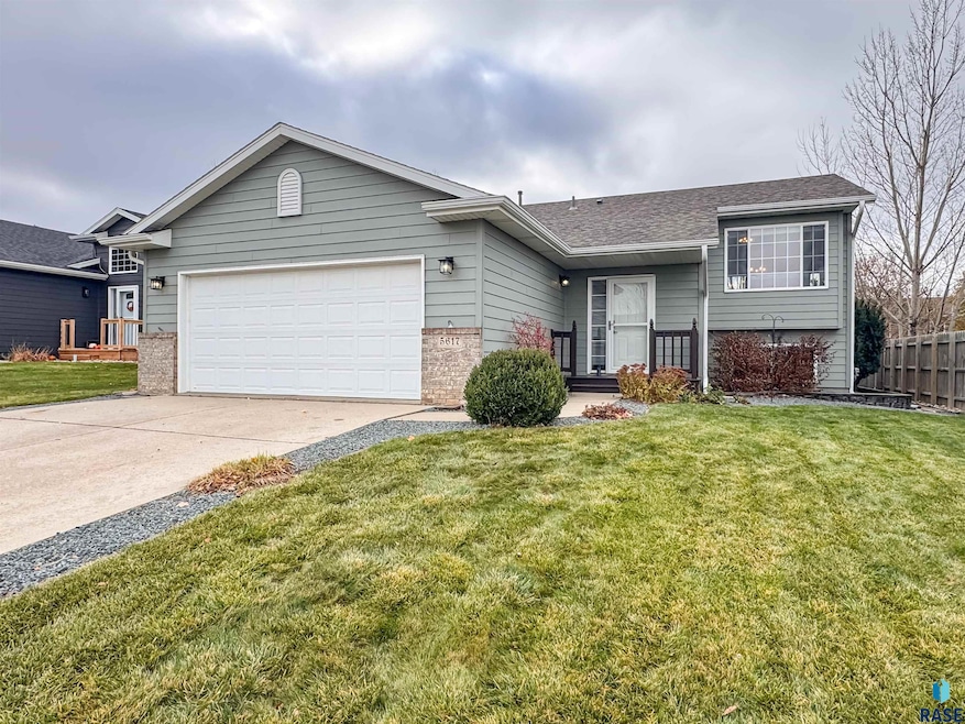


Here it is!! Discover this well-maintained 4 bed, 2 bath split-foyer home in a quiet northwest Sioux Falls neighborhood. Enjoy an open floor plan with vaulted ceilings, vinyl plank flooring throughout, and fresh paint. The bright living room flows into the kitchen with a breakfast bar and the dining room with a slider to the deck. The master bedroom features a walk-in closet and shares a full bath with the 2nd bedroom. Downstairs offers a spacious family room with garden-level windows, two additional bedrooms, a full bath, laundry, and a finished storage area. Outside, enjoy a fully fenced backyard with a stone patio, newer roof and a finished 2-stall garage with a minisplit. Don’t miss your chance—schedule a showing today!
| Date | Type | Sale Price | Title Company |
|---|---|---|---|
| Warranty Deed | $332,500 | Getty Abstract & Title Co | |
| Warranty Deed | $322,500 | Stewart Title Co | |
| Warranty Deed | $322,500 | Stewart Title Co |
| Date | Status | Loan Amount | Loan Type |
|---|---|---|---|
| Open | $212,500 | Purchase Money Mortgage | |
| Previous Owner | $297,500 | No Value Available |
| Date | Event | Price | List to Sale | Price per Sq Ft |
|---|---|---|---|---|
| 01/22/2026 01/22/26 | Sold | $332,500 | -2.2% | $188 / Sq Ft |
| 12/10/2025 12/10/25 | Pending | -- | -- | -- |
| 11/20/2025 11/20/25 | For Sale | $339,900 | -- | $192 / Sq Ft |
| Year | Tax Paid | Tax Assessment Tax Assessment Total Assessment is a certain percentage of the fair market value that is determined by local assessors to be the total taxable value of land and additions on the property. | Land | Improvement |
|---|---|---|---|---|
| 2024 | $3,583 | $264,900 | $24,500 | $240,400 |
| 2023 | $3,525 | $250,900 | $24,500 | $226,400 |
| 2022 | $3,256 | $218,300 | $24,500 | $193,800 |
| 2021 | $2,688 | $192,800 | $0 | $0 |
| 2020 | $2,688 | $172,200 | $0 | $0 |
| 2019 | $2,590 | $162,889 | $0 | $0 |
| 2018 | $2,279 | $155,969 | $0 | $0 |
| 2017 | $2,242 | $143,525 | $23,328 | $120,197 |
| 2016 | $2,242 | $141,340 | $23,328 | $118,012 |
| 2015 | $2,221 | $134,580 | $22,032 | $112,548 |
| 2014 | -- | $138,457 | $22,262 | $116,195 |
Seller's Agent in 2026
David Dreessen
Alpine Residential
(605) 201-1506
18 in this area
165 Total Sales
B
Buyer's Agent in 2026
Baillie Hanson
Alpine Residential
(605) 222-7472
1 in this area
16 Total Sales
Source: REALTOR® Association of the Sioux Empire
MLS Number: 22508703
APN: 80465
Disclaimer: Certain information contained herein is derived from information provided by parties other than Homes.com. All information provided is deemed reliable, but is not guaranteed to be accurate and should be independently verified.
![]() The data relating to real estate for sale on this web site comes in part from the Internet Data Exchange Program of the REALTOR® Association of the Sioux Empire, Inc., Multiple Listing Service. Real estate listings held by brokerage firms other than Ten-X are marked with the Internet Data Exchange™ logo or the Internet Data Exchange thumbnail logo (a little black house) and detailed information about them includes the name of the listing brokers.
The data relating to real estate for sale on this web site comes in part from the Internet Data Exchange Program of the REALTOR® Association of the Sioux Empire, Inc., Multiple Listing Service. Real estate listings held by brokerage firms other than Ten-X are marked with the Internet Data Exchange™ logo or the Internet Data Exchange thumbnail logo (a little black house) and detailed information about them includes the name of the listing brokers.
Information is deemed reliable but not guaranteed.
Copyright 2026 REALTOR® Association of the Sioux Empire, Inc., Inc. Multiple Listing Service. All rights reserved.
Ask me questions while you tour the home.