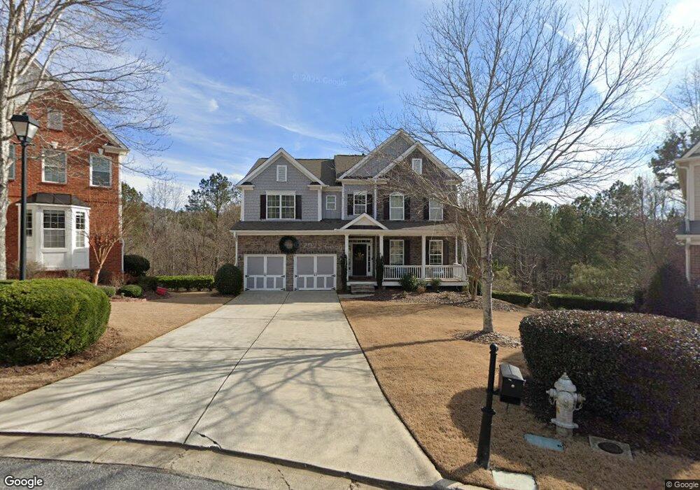
5618 Lancashire Ln Cumming, GA 30041
Estimated Value: $714,027 - $776,000
4
Beds
3
Baths
3,535
Sq Ft
$212/Sq Ft
Est. Value
About This Home
This home is located at 5618 Lancashire Ln, Cumming, GA 30041 and is currently estimated at $748,257, approximately $211 per square foot. 5618 Lancashire Ln is a home located in Forsyth County with nearby schools including Haw Creek Elementary School, Lakeside Middle School, and South Forsyth High School.
Ownership History
Date
Name
Owned For
Owner Type
Purchase Details
Closed on
Jul 29, 2005
Sold by
D R Horton Inc
Bought by
Robertson Robert and Robertson Melanie
Current Estimated Value
Home Financials for this Owner
Home Financials are based on the most recent Mortgage that was taken out on this home.
Original Mortgage
$282,595
Outstanding Balance
$147,017
Interest Rate
5.51%
Mortgage Type
New Conventional
Estimated Equity
$601,240
Create a Home Valuation Report for This Property
The Home Valuation Report is an in-depth analysis detailing your home's value as well as a comparison with similar homes in the area
Home Values in the Area
Average Home Value in this Area
Purchase History
| Date | Buyer | Sale Price | Title Company |
|---|---|---|---|
| Robertson Robert | $363,300 | -- |
Source: Public Records
Mortgage History
| Date | Status | Borrower | Loan Amount |
|---|---|---|---|
| Open | Robertson Robert | $282,595 |
Source: Public Records
Tax History Compared to Growth
Tax History
| Year | Tax Paid | Tax Assessment Tax Assessment Total Assessment is a certain percentage of the fair market value that is determined by local assessors to be the total taxable value of land and additions on the property. | Land | Improvement |
|---|---|---|---|---|
| 2025 | $5,281 | $282,704 | $76,000 | $206,704 |
| 2024 | $5,281 | $248,104 | $68,000 | $180,104 |
| 2023 | $5,633 | $287,500 | $60,000 | $227,500 |
| 2022 | $5,229 | $183,456 | $32,000 | $151,456 |
| 2021 | $4,744 | $183,456 | $32,000 | $151,456 |
| 2020 | $4,331 | $163,432 | $32,000 | $131,432 |
| 2019 | $4,475 | $170,088 | $32,000 | $138,088 |
| 2018 | $4,302 | $161,384 | $26,000 | $135,384 |
| 2017 | $4,092 | $150,704 | $26,000 | $124,704 |
| 2016 | $4,092 | $150,704 | $26,000 | $124,704 |
| 2015 | $4,099 | $150,704 | $26,000 | $124,704 |
| 2014 | $3,483 | $134,844 | $0 | $0 |
Source: Public Records
Map
Nearby Homes
- 5613 Lancashire Ln
- 2350 Gladstone Place
- 5303 Davenport Manor
- 2400 Gants Hill Place
- 3138 Neal Ct
- 6143 Menlow Ct
- 3147 Neal Ct
- 3105 Neal Ct
- 2640 Blackstock Dr
- 5985 Marlow Dr
- 2625 Blackstock Dr
- 5349 Davenport Manor
- 2410 Overpass
- Manchester Plan at The Glade
- Belville Plan at The Glade
- Milton Plan at The Glade
- 2945 Links View Way
- 6705 Marlow Dr
- 5616 Lancashire Ln
- 5625 Lancashire Ln
- 5623 Lancashire Ln Unit 919
- 5623 Lancashire Ln
- 5614 Lancashire Ln
- 5621 Lancashire Ln
- 5612 Lancashire Ln
- 5619 Lancashire Ln
- 5610 Lancashire Ln
- 5429 Landsdowne Ct
- 5431 Landsdowne Ct
- 5617 Lancashire Ln
- 5608 Lancashire Ln
- 5427 Landsdowne Ct
- 3015 Waterstone Dr
- 5433 Landsdowne Ct Unit 928
- 5433 Landsdowne Ct
- 3025 Waterstone Dr
- 5425 Landsdowne Ct
- 5602 Lancashire Ln