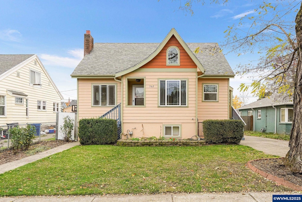
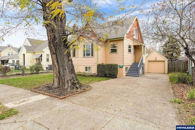


562 21st St NE Salem, OR 97301
Northeast Neighbors NeighborhoodEstimated payment $2,389/month
Highlights
- RV Access or Parking
- Wood Flooring
- Lower Floor Utility Room
- Living Room with Fireplace
- Main Floor Primary Bedroom
- 3-minute walk to McRae Park
About This Home
Solid 1928 home. Newer foundation, windows, siding. High efficiency gas furnace & central air. Beautiful outdoor patio area. Deep driveway offers tandem off-off street parking. Amazingly low taxes! Newer cabinets on main kitchen. LVP flooring. Enjoy Macrae Park, nearby. About 1 mile from department store shopping & theatre, Roth's and Safeway.
Listing Agent
BERKSHIRE HATHAWAY HOMESERVICES R E PROF License #900200196 Listed on: 11/11/2025

Home Details
Home Type
- Single Family
Est. Annual Taxes
- $2,418
Year Built
- Built in 1928
Lot Details
- 5,000 Sq Ft Lot
- Lot Dimensions are 50x100
- Fenced Yard
- Landscaped
- Property is zoned RS
Home Design
- Slab Foundation
- Composition Roof
- Lap Siding
Interior Spaces
- 2,442 Sq Ft Home
- 1.5-Story Property
- Wood Burning Fireplace
- Living Room with Fireplace
- Lower Floor Utility Room
- Finished Basement
Kitchen
- Electric Range
- Dishwasher
- Disposal
Flooring
- Wood
- Carpet
- Luxury Vinyl Plank Tile
Bedrooms and Bathrooms
- 4 Bedrooms
- Primary Bedroom on Main
- 2 Full Bathrooms
Parking
- 1 Car Detached Garage
- RV Access or Parking
Outdoor Features
- Patio
Schools
- Englewood Elementary School
- Parrish Middle School
- North Salem High School
Utilities
- Forced Air Heating and Cooling System
- Heating System Uses Gas
- Electric Water Heater
- High Speed Internet
Community Details
- Walnut Park Addition Subdivision
Listing and Financial Details
- Legal Lot and Block 15 / 6
Map
Home Values in the Area
Average Home Value in this Area
Tax History
| Year | Tax Paid | Tax Assessment Tax Assessment Total Assessment is a certain percentage of the fair market value that is determined by local assessors to be the total taxable value of land and additions on the property. | Land | Improvement |
|---|---|---|---|---|
| 2025 | $2,418 | $126,850 | -- | -- |
| 2024 | $2,418 | $123,160 | -- | -- |
| 2023 | $2,347 | $119,580 | $0 | $0 |
| 2022 | $2,213 | $116,100 | $0 | $0 |
| 2021 | $2,150 | $112,720 | $0 | $0 |
| 2020 | $1,837 | $93,420 | $0 | $0 |
| 2019 | $1,772 | $90,700 | $0 | $0 |
| 2018 | $1,749 | $0 | $0 | $0 |
| 2017 | $1,579 | $0 | $0 | $0 |
| 2016 | $1,504 | $0 | $0 | $0 |
| 2015 | $1,515 | $0 | $0 | $0 |
| 2014 | $1,467 | $0 | $0 | $0 |
Property History
| Date | Event | Price | List to Sale | Price per Sq Ft |
|---|---|---|---|---|
| 11/11/2025 11/11/25 | For Sale | $415,000 | -- | $170 / Sq Ft |
Purchase History
| Date | Type | Sale Price | Title Company |
|---|---|---|---|
| Warranty Deed | $133,000 | Fidelity Natl Title Co Of Or | |
| Interfamily Deed Transfer | -- | Fidelity Natl Title Co Of Or |
Mortgage History
| Date | Status | Loan Amount | Loan Type |
|---|---|---|---|
| Open | $99,750 | Purchase Money Mortgage |
Source: Willamette Valley MLS
MLS Number: 835301
APN: 595707
Disclaimer: Certain information contained herein is derived from information provided by parties other than Homes.com. All information provided is deemed reliable, but is not guaranteed to be accurate and should be independently verified.
![]() Based on information from Willamette Valley Multiple Listing Service, which neither guarantees nor is in any way responsible for its accuracy. All data is provided ‘AS IS’ and with all faults. Data maintained by Willamette Valley Multiple Listing Service may not reflect all real estate activity in the market. WVMLS Member Broker: Arlene Richardson
Based on information from Willamette Valley Multiple Listing Service, which neither guarantees nor is in any way responsible for its accuracy. All data is provided ‘AS IS’ and with all faults. Data maintained by Willamette Valley Multiple Listing Service may not reflect all real estate activity in the market. WVMLS Member Broker: Arlene Richardson
- 1965 Breyman St NE
- 578 23rd St NE
- 664 Thompson Ave NE Unit 672
- 680 Breys Ave NE
- 1836 Center St NE
- 399 24th St NE
- 637 17th St NE
- 140 21st St NE
- 1675 B St NE
- 1795 Court St NE
- 1859 State St
- 241 NW 25th St
- 241 NE St
- 2196 State St
- 1735 D St NE
- 1596 Chemeketa St NE
- 135 Wander Way SE
- 220 24th St SE
- 1496 Court St NE
- 1212 23rd St NE
- 1180 17th St NE
- 1245 Chemeketa St NE
- 1150 12th St NE
- 585 Winter St NE
- 1461-1491 Lee St SE
- 1065 Madison St NE
- 424 Center St NE
- 1127 Broadway St NE
- 1127 Broadway St NE
- 1127 Broadway St NE
- 1127 Broadway St NE
- 295 Colt Ln NE
- 975 Cross St SE
- 315 Commercial St SE
- 1415 Lancaster Dr NE
- 805-895 Liberty St SE
- 777 Commercial St SE
- 3864 Sunnyview Rd NE
- 1601-1665 Water St NE
- 178 Lancaster Dr SE