Estimated Value: $40,000 - $170,000
Studio
--
Bath
--
Sq Ft
14,810
Sq Ft
About This Home
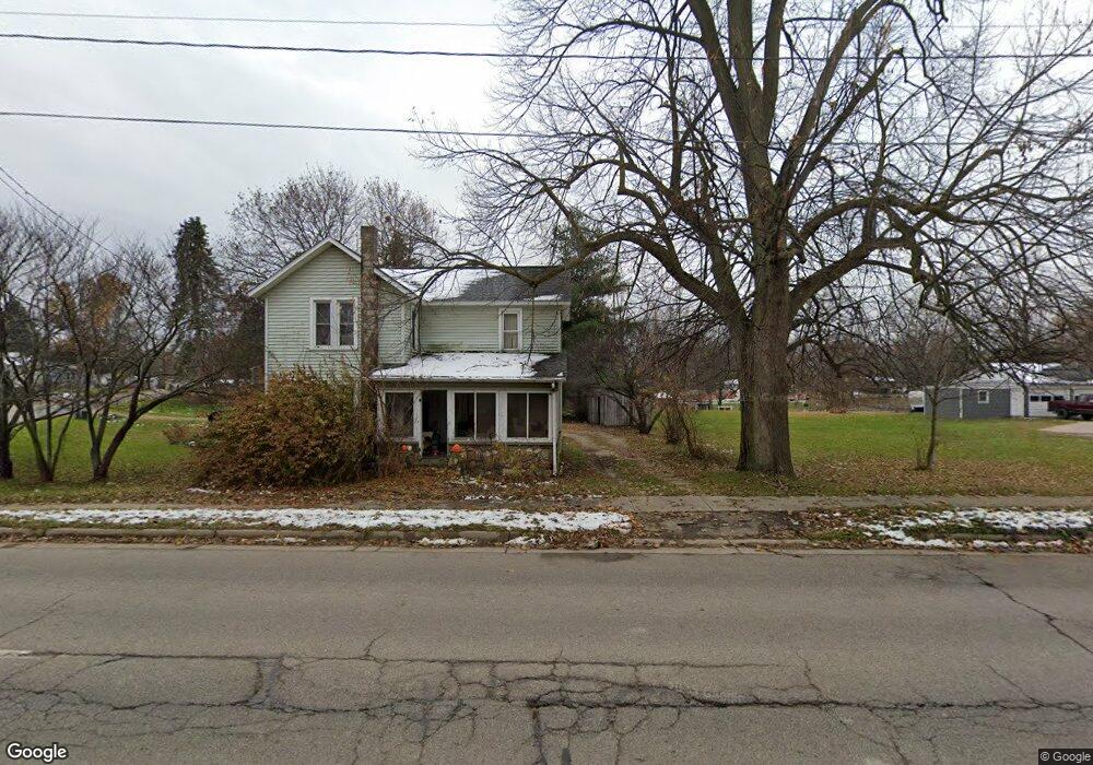
This home is located at 562 E State St, Colon, MI 49040 and is currently estimated at $122,516. 562 E State St is a home located in St. Joseph County.
Ownership History
Date
Name
Owned For
Owner Type
Purchase Details
Closed on
May 23, 2015
Sold by
Hughes Tara and Klingerman Patrick
Bought by
Hughes Joseph E
Current Estimated Value
Home Financials for this Owner
Home Financials are based on the most recent Mortgage that was taken out on this home.
Original Mortgage
$65,240
Outstanding Balance
$51,276
Interest Rate
4.25%
Mortgage Type
FHA
Estimated Equity
$71,240
Purchase Details
Closed on
Oct 24, 2008
Sold by
Johnson Tammy
Bought by
Hughes Joseph E and Hughes Tara
Home Financials for this Owner
Home Financials are based on the most recent Mortgage that was taken out on this home.
Original Mortgage
$68,681
Interest Rate
5.94%
Mortgage Type
FHA
Purchase Details
Closed on
Dec 20, 2007
Sold by
Webb Heather
Bought by
Aurora Loan Services Llc
Purchase Details
Closed on
Nov 18, 1999
Sold by
Webb Michael W and Webb Heather
Bought by
Webb Heather
Purchase Details
Closed on
Feb 27, 1998
Purchase Details
Closed on
Jan 1, 1901
Create a Home Valuation Report for This Property
The Home Valuation Report is an in-depth analysis detailing your home's value as well as a comparison with similar homes in the area
Purchase History
| Date | Buyer | Sale Price | Title Company |
|---|---|---|---|
| Hughes Joseph E | -- | Associates Title Inc | |
| Hughes Joseph E | $81,000 | Patrick Abstract | |
| Aurora Loan Services Llc | $97,818 | None Available | |
| Webb Heather | -- | -- | |
| -- | -- | -- | |
| -- | -- | -- |
Source: Public Records
Mortgage History
| Date | Status | Borrower | Loan Amount |
|---|---|---|---|
| Open | Hughes Joseph E | $65,240 | |
| Closed | Hughes Joseph E | $68,681 |
Source: Public Records
Tax History
| Year | Tax Paid | Tax Assessment Tax Assessment Total Assessment is a certain percentage of the fair market value that is determined by local assessors to be the total taxable value of land and additions on the property. | Land | Improvement |
|---|---|---|---|---|
| 2025 | $160 | $9,900 | $9,900 | $0 |
| 2024 | $156 | $7,300 | $7,300 | $0 |
| 2023 | $170 | $7,300 | $7,300 | $0 |
| 2022 | $0 | $7,300 | $7,300 | $0 |
| 2021 | $102 | $7,300 | $7,300 | $0 |
| 2020 | $75 | $5,500 | $5,500 | $0 |
| 2019 | $58 | $5,500 | $5,500 | $0 |
| 2018 | $213 | $5,500 | $5,500 | $0 |
| 2017 | $147 | $5,800 | $5,800 | $0 |
| 2016 | -- | $5,200 | $5,200 | $0 |
| 2015 | -- | $5,200 | $0 | $0 |
| 2014 | -- | $5,200 | $5,200 | $0 |
| 2012 | -- | $5,200 | $5,200 | $0 |
Source: Public Records
Map
Nearby Homes
- 161 Palmer Ave
- 120 Palmer Ave
- 407 Barry St
- 210 E South St
- 622 Maple St
- 309 N Blackstone Ave
- 0 N Burr Oak Rd
- VL Bowman St
- 917 Elm St
- 448 Long Lake Rd
- 0 S Farrand Unit 25051538
- 58954 Lakeshore Dr
- 59178 Nora Dr
- 31688 W Colon Rd
- 31908 Decker Rd
- 30725 Orla Engle Rd
- 0 Coohon Rd
- 55637 Bennett Rd
- 1121 Heights Dr
- VL Heights Dr
Your Personal Tour Guide
Ask me questions while you tour the home.