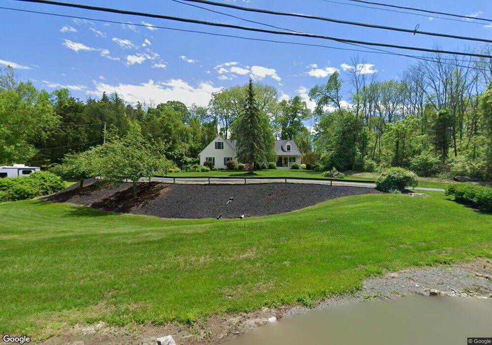
562 Ervey Rd Andover, NJ 07821
Estimated Value: $576,000 - $664,000
--
Bed
--
Bath
2,516
Sq Ft
$248/Sq Ft
Est. Value
About This Home
This home is located at 562 Ervey Rd, Andover, NJ 07821 and is currently estimated at $624,208, approximately $248 per square foot. 562 Ervey Rd is a home located in Warren County with nearby schools including Mountain Villa School, Allamuchy Township Elementary School, and Tranquility Adventist School.
Ownership History
Date
Name
Owned For
Owner Type
Purchase Details
Closed on
Sep 30, 2003
Sold by
Painter Harry William and Painter Suzanne J
Bought by
Berger Kim and Berger Deborah
Current Estimated Value
Home Financials for this Owner
Home Financials are based on the most recent Mortgage that was taken out on this home.
Original Mortgage
$165,000
Interest Rate
6.25%
Mortgage Type
Purchase Money Mortgage
Purchase Details
Closed on
Sep 26, 1995
Sold by
Magi Tarmu and Magi Jean R
Bought by
Painter Harry William and Painter Suzanne J
Create a Home Valuation Report for This Property
The Home Valuation Report is an in-depth analysis detailing your home's value as well as a comparison with similar homes in the area
Home Values in the Area
Average Home Value in this Area
Purchase History
| Date | Buyer | Sale Price | Title Company |
|---|---|---|---|
| Berger Kim | $375,000 | -- | |
| Painter Harry William | $40,000 | -- |
Source: Public Records
Mortgage History
| Date | Status | Borrower | Loan Amount |
|---|---|---|---|
| Closed | Berger Kim | $165,000 |
Source: Public Records
Tax History Compared to Growth
Tax History
| Year | Tax Paid | Tax Assessment Tax Assessment Total Assessment is a certain percentage of the fair market value that is determined by local assessors to be the total taxable value of land and additions on the property. | Land | Improvement |
|---|---|---|---|---|
| 2025 | $11,774 | $366,800 | $98,000 | $268,800 |
| 2024 | $11,667 | $366,800 | $98,000 | $268,800 |
| 2023 | $11,425 | $366,800 | $98,000 | $268,800 |
| 2022 | $11,425 | $366,800 | $98,000 | $268,800 |
| 2021 | $8,360 | $366,800 | $98,000 | $268,800 |
| 2020 | $10,832 | $366,800 | $98,000 | $268,800 |
| 2019 | $10,656 | $366,800 | $98,000 | $268,800 |
| 2018 | $10,873 | $366,800 | $98,000 | $268,800 |
| 2017 | $10,769 | $366,800 | $98,000 | $268,800 |
| 2016 | $10,689 | $366,800 | $98,000 | $268,800 |
| 2015 | $10,743 | $366,800 | $98,000 | $268,800 |
| 2014 | $10,283 | $366,800 | $98,000 | $268,800 |
Source: Public Records
Map
Nearby Homes
- 8 Limekiln Ct
- 88 Kennedy Rd
- 37 Pequest Rd
- 73 Wolfs Corner Rd
- 78 Hillside Terrace
- 8 Woodfield Rd
- 14 Hillside Terrace
- 0 Decker Pond Airport Rd Unit 3945534
- 10 Rushmore Ln
- 19 Rainier Ct
- 5 Ajax Ct
- 15 Ajax Ct
- 300 Alphano Rd
- 25 Osprey Unit C2G3
- 247 Main St
- 244 Main St
- 57 Marsh Hawk Unit 8
- 411 Shades of Death Rd
- 156 Osprey Unit 5
- 288 Decker Pond Rd