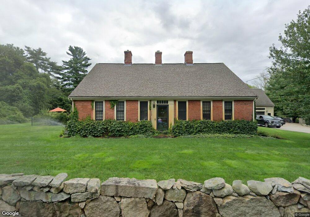
562 King St Hanover, MA 02339
Estimated Value: $1,069,679 - $1,212,000
3
Beds
4
Baths
3,890
Sq Ft
$292/Sq Ft
Est. Value
About This Home
This home is located at 562 King St, Hanover, MA 02339 and is currently estimated at $1,137,670, approximately $292 per square foot. 562 King St is a home located in Plymouth County with nearby schools including Hanover High School.
Ownership History
Date
Name
Owned For
Owner Type
Purchase Details
Closed on
Mar 10, 2014
Sold by
Martin Christopher and Martin Deborah E
Bought by
Obrien Patrick and Obrien Jennie
Current Estimated Value
Home Financials for this Owner
Home Financials are based on the most recent Mortgage that was taken out on this home.
Original Mortgage
$465,000
Outstanding Balance
$351,050
Interest Rate
4.39%
Mortgage Type
New Conventional
Estimated Equity
$786,620
Purchase Details
Closed on
Jan 13, 2014
Sold by
Campbell Clifton R and Minto Muriel E
Bought by
Martin Christopher and Martin Deborah E
Home Financials for this Owner
Home Financials are based on the most recent Mortgage that was taken out on this home.
Original Mortgage
$465,000
Outstanding Balance
$351,050
Interest Rate
4.39%
Mortgage Type
New Conventional
Estimated Equity
$786,620
Purchase Details
Closed on
Jun 13, 1997
Sold by
Campbell Clifton R and Campbell Muriel H
Bought by
Martin Christopher and Martin Deborah E
Create a Home Valuation Report for This Property
The Home Valuation Report is an in-depth analysis detailing your home's value as well as a comparison with similar homes in the area
Home Values in the Area
Average Home Value in this Area
Purchase History
| Date | Buyer | Sale Price | Title Company |
|---|---|---|---|
| Obrien Patrick | $599,000 | -- | |
| Martin Christopher | -- | -- | |
| Martin Christopher | $156,000 | -- |
Source: Public Records
Mortgage History
| Date | Status | Borrower | Loan Amount |
|---|---|---|---|
| Open | Obrien Patrick | $465,000 | |
| Previous Owner | Martin Christopher | $250,000 | |
| Previous Owner | Martin Christopher | $75,000 | |
| Previous Owner | Martin Christopher | $25,000 |
Source: Public Records
Tax History Compared to Growth
Tax History
| Year | Tax Paid | Tax Assessment Tax Assessment Total Assessment is a certain percentage of the fair market value that is determined by local assessors to be the total taxable value of land and additions on the property. | Land | Improvement |
|---|---|---|---|---|
| 2025 | $10,452 | $846,300 | $280,500 | $565,800 |
| 2024 | $10,362 | $807,000 | $280,500 | $526,500 |
| 2023 | $10,791 | $799,900 | $255,200 | $544,700 |
| 2022 | $11,712 | $768,000 | $242,500 | $525,500 |
| 2021 | $11,397 | $697,900 | $197,400 | $500,500 |
| 2020 | $12,896 | $790,700 | $209,000 | $581,700 |
| 2019 | $11,364 | $692,500 | $209,000 | $483,500 |
| 2018 | $87 | $553,300 | $209,000 | $344,300 |
| 2017 | $8,845 | $535,400 | $205,100 | $330,300 |
| 2016 | $10,745 | $637,300 | $186,500 | $450,800 |
| 2015 | $7,122 | $441,000 | $172,800 | $268,200 |
Source: Public Records
Map
Nearby Homes
- 108 Waterford Dr
- 12 Hayford Trail Unit 17
- 7 Hayford Trail Unit 12
- 5 Hayford Trail Unit 11
- 22 Howland Trail Unit 34
- 418 E Washington St
- 168 Spring St
- 842 Whitman St
- 14 Birch Bottom Cir
- 95 Tecumseh Dr
- 33 Tavern Way
- 430 Brook Bend Rd
- Lot 5 Princeton Way
- 75 School St
- 84 Liberty St
- 10 Proud Foot Way
- 23 Live Oak Way
- 26 Stonebridge Dr
- 561 Circuit St
- 1269 Whitman St