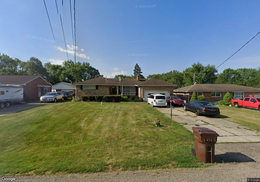
5622 Mowry St Louisville, OH 44641
Estimated Value: $221,000 - $272,000
3
Beds
3
Baths
1,702
Sq Ft
$145/Sq Ft
Est. Value
About This Home
This home is located at 5622 Mowry St, Louisville, OH 44641 and is currently estimated at $245,941, approximately $144 per square foot. 5622 Mowry St is a home located in Stark County with nearby schools including Louisville High School, East Branch Preparatory Academy Wright Preparatory Academy, and Canton Harbor High School.
Ownership History
Date
Name
Owned For
Owner Type
Purchase Details
Closed on
Oct 1, 1997
Sold by
Riley Wayne H
Bought by
Legg Eugene F and Legg Cynthia
Current Estimated Value
Home Financials for this Owner
Home Financials are based on the most recent Mortgage that was taken out on this home.
Original Mortgage
$117,800
Outstanding Balance
$19,075
Interest Rate
7.54%
Mortgage Type
New Conventional
Estimated Equity
$226,866
Purchase Details
Closed on
Aug 13, 1990
Create a Home Valuation Report for This Property
The Home Valuation Report is an in-depth analysis detailing your home's value as well as a comparison with similar homes in the area
Home Values in the Area
Average Home Value in this Area
Purchase History
| Date | Buyer | Sale Price | Title Company |
|---|---|---|---|
| Legg Eugene F | $102,000 | -- | |
| -- | $75,000 | -- |
Source: Public Records
Mortgage History
| Date | Status | Borrower | Loan Amount |
|---|---|---|---|
| Open | Legg Eugene F | $117,800 |
Source: Public Records
Tax History Compared to Growth
Tax History
| Year | Tax Paid | Tax Assessment Tax Assessment Total Assessment is a certain percentage of the fair market value that is determined by local assessors to be the total taxable value of land and additions on the property. | Land | Improvement |
|---|---|---|---|---|
| 2025 | -- | $79,280 | $12,040 | $67,240 |
| 2024 | -- | $79,280 | $12,040 | $67,240 |
| 2023 | $2,595 | $53,380 | $9,770 | $43,610 |
| 2022 | $2,601 | $53,380 | $9,770 | $43,610 |
| 2021 | $2,609 | $53,380 | $9,770 | $43,610 |
| 2020 | $2,154 | $46,560 | $8,790 | $37,770 |
| 2019 | $2,162 | $46,560 | $8,790 | $37,770 |
| 2018 | $2,156 | $46,560 | $8,790 | $37,770 |
| 2017 | $2,152 | $44,380 | $6,580 | $37,800 |
| 2016 | $2,104 | $44,380 | $6,580 | $37,800 |
| 2015 | $2,110 | $44,380 | $6,580 | $37,800 |
| 2014 | $120 | $41,270 | $6,130 | $35,140 |
| 2013 | $1,064 | $41,270 | $6,130 | $35,140 |
Source: Public Records
Map
Nearby Homes
- 4481 Broadway Ave NE
- 4465 Eastland Ave NE
- 3894 Tulane Ave
- 424 Honeycrisp Dr NE
- 2974 Mcintosh Dr NE
- 2969 Mcintosh Dr NE
- 2975 Mcintosh Dr NE
- 2980 Mcintosh Dr NE
- 2981 Mcintosh Dr NE
- 420 Honeycrisp Dr NE
- 414 Honeycrisp Dr NE
- Goldenrod Plan at Orchard Park - Aspire Single Family Collection
- Forsythia Plan at Orchard Park - Aspire Single Family Collection
- Oleander Plan at Orchard Park - Aspire Single Family Collection
- Water Lily Plan at Orchard Park - Aspire Single Family Collection
- Beckfield Plan at Orchard Park - Aspire Townhome Collection
- 6083 Apple St
- 4385 Fruitland Ave
- 4060 Hambleton Ave NE
- 5208 Oakridge Dr
- 5626 Mowry St
- 5616 Mowry St
- 5636 Mowry St
- 5588 Mowry St
- 5599 Mowry St
- 5585 Mowry St
- 5650 Mowry St
- 5629 Mowry St
- 5574 Mowry St
- 5565 Mowry St
- 5649 Mowry St
- 5670 Mowry St
- 4235 Gephart Ave
- 4288 Broadway Ave
- 4260 Broadway Ave NE
- 4329 Gephart Ave
- 4292 Gephart Ave
- 4270 Gephart Ave
- 4240 Gephart Ave
- 4320 Broadway Ave