Estimated Value: $255,759 - $298,000
3
Beds
2
Baths
1,248
Sq Ft
$225/Sq Ft
Est. Value
About This Home
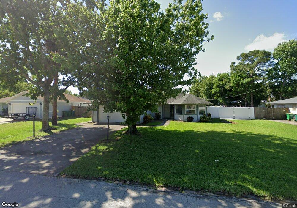
This home is located at 5625 Fairbridge St, Cocoa, FL 32927 and is currently estimated at $280,190, approximately $224 per square foot. 5625 Fairbridge St is a home located in Brevard County with nearby schools including Enterprise Elementary School, Space Coast Junior/Senior High School, and East Atlantic Prep of Brevard County.
Ownership History
Date
Name
Owned For
Owner Type
Purchase Details
Closed on
Aug 27, 2003
Sold by
Krell Gentry Sallie
Bought by
Maul John and Maul Nancy
Current Estimated Value
Home Financials for this Owner
Home Financials are based on the most recent Mortgage that was taken out on this home.
Original Mortgage
$95,000
Outstanding Balance
$47,103
Interest Rate
7.25%
Estimated Equity
$233,087
Create a Home Valuation Report for This Property
The Home Valuation Report is an in-depth analysis detailing your home's value as well as a comparison with similar homes in the area
Home Values in the Area
Average Home Value in this Area
Purchase History
| Date | Buyer | Sale Price | Title Company |
|---|---|---|---|
| Maul John | $95,000 | Gulfatlantic Title |
Source: Public Records
Mortgage History
| Date | Status | Borrower | Loan Amount |
|---|---|---|---|
| Open | Maul John | $95,000 |
Source: Public Records
Tax History
| Year | Tax Paid | Tax Assessment Tax Assessment Total Assessment is a certain percentage of the fair market value that is determined by local assessors to be the total taxable value of land and additions on the property. | Land | Improvement |
|---|---|---|---|---|
| 2025 | $1,009 | $72,150 | -- | -- |
| 2024 | $973 | $70,120 | -- | -- |
| 2023 | $973 | $65,500 | $0 | $0 |
| 2022 | $922 | $63,600 | $0 | $0 |
| 2021 | $923 | $61,750 | $0 | $0 |
| 2020 | $878 | $60,900 | $0 | $0 |
| 2019 | $825 | $59,540 | $0 | $0 |
| 2018 | $826 | $58,430 | $0 | $0 |
| 2017 | $826 | $57,230 | $0 | $0 |
| 2016 | $832 | $56,060 | $18,000 | $38,060 |
| 2015 | $837 | $55,680 | $15,000 | $40,680 |
| 2014 | $841 | $55,240 | $11,000 | $44,240 |
Source: Public Records
Map
Nearby Homes
- 5721 Beaverbrook St
- 6481 La Brea Ave
- 6581 Bancroft Ave
- 5680 Banos Ave
- 6643 Emil Ave
- 6438 Hudson Rd
- 6460 Ainsworth Rd
- 6615 Dock Ave
- 0 Aruin St Unit 1222557
- 6460 Homestead Ave
- 23-35-21-JX-B-2 Aruin St
- 6545 Addie Ave
- 6450 Ember Ave
- 6250 Ainsworth Rd
- 5555 Brandon St
- 6760 Cairo Rd
- 5680 Brandon St
- 6815 Bryant Rd
- 00 Unknown
- 6135 Allmont St
- 0000 No Name
- 7300 N Us Highway ! Hwy Unit 206
- 4650 N Highway 1 Hwy
- 0 No Street Address Unit 333694
- 2313006 Blk 1 & 1 2 Lots 2 3 Can Grov St
- 2313642 Section 32 Block 12 Lot 9
- 231790 Section 32 Block 18 Can Grove
- 0 No Street Address Unit 936304
- 5605 Fairbridge St
- 5645 Fairbridge St
- 5648 Beaverbrook St
- 5660 Beaverbrook St
- 5636 Beaverbrook St
- 5595 Fairbridge St Unit 4
- 5595 Fairbridge St
- 5665 Fairbridge St
- 5640 Fairbridge St
- 5620 Fairbridge St
- 5660 Fairbridge St
- 5672 Beaverbrook St
Your Personal Tour Guide
Ask me questions while you tour the home.