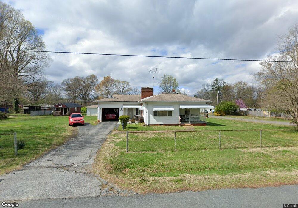
5630 Bertie Ave Salisbury, NC 28147
Estimated Value: $189,326 - $291,000
Studio
1
Bath
1,116
Sq Ft
$205/Sq Ft
Est. Value
About This Home
This home is located at 5630 Bertie Ave, Salisbury, NC 28147 and is currently estimated at $228,832, approximately $205 per square foot. 5630 Bertie Ave is a home located in Rowan County with nearby schools including Knollwood Elementary School, Southeast Middle School, and Jesse C Carson High School.
Ownership History
Date
Name
Owned For
Owner Type
Purchase Details
Closed on
Mar 8, 2016
Sold by
Allmon David Rodger
Bought by
Allmon David Rodger
Current Estimated Value
Purchase Details
Closed on
Jan 2, 2013
Bought by
Allmon Rodger Bruce
Purchase Details
Closed on
Dec 30, 2003
Sold by
Allmon Metta Clodfelter
Bought by
Allmon Rodger B
Purchase Details
Closed on
Nov 17, 2003
Sold by
Allmon Rodger B and Allmon Phyllis B
Bought by
Allmon Metta Clodfelter and Allmon Rodger B
Purchase Details
Closed on
Nov 14, 2003
Sold by
Allmon Metta Clodfelter
Bought by
Allmon Metta Clodfelter and Allmon Rodger B
Create a Home Valuation Report for This Property
The Home Valuation Report is an in-depth analysis detailing your home's value as well as a comparison with similar homes in the area
Purchase History
| Date | Buyer | Sale Price | Title Company |
|---|---|---|---|
| Allmon David Rodger | -- | None Available | |
| Allmon Rodger Bruce | -- | -- | |
| Allmon Rodger B | -- | None Available | |
| Allmon Metta Clodfelter | -- | -- | |
| Allmon Metta Clodfelter | -- | -- |
Source: Public Records
Tax History
| Year | Tax Paid | Tax Assessment Tax Assessment Total Assessment is a certain percentage of the fair market value that is determined by local assessors to be the total taxable value of land and additions on the property. | Land | Improvement |
|---|---|---|---|---|
| 2025 | $894 | $131,920 | $30,300 | $101,620 |
| 2024 | $894 | $131,920 | $30,300 | $101,620 |
| 2023 | $894 | $131,920 | $30,300 | $101,620 |
| 2022 | $552 | $73,074 | $21,937 | $51,137 |
| 2021 | $546 | $73,074 | $21,937 | $51,137 |
| 2020 | $546 | $73,074 | $21,937 | $51,137 |
| 2019 | $546 | $73,074 | $21,937 | $51,137 |
| 2018 | $536 | $72,294 | $25,452 | $46,842 |
| 2017 | $536 | $72,294 | $25,452 | $46,842 |
| 2016 | $536 | $72,294 | $25,452 | $46,842 |
| 2015 | $542 | $72,294 | $25,452 | $46,842 |
| 2014 | $476 | $66,531 | $17,717 | $48,814 |
Source: Public Records
Map
Nearby Homes
- 5650 Bertie Ave
- 355 Swink Ave
- 6255 Meadow Ln
- 735 Grace Church Rd
- 1080 Beckham Rd
- 1060 Beckham Rd
- 620 Mount Hope Church Rd
- 0 Brookfield Cir Unit CAR4292885
- 228 Hollybrook Ct
- 1140 Peeler Rd
- 1352 Eva Ln
- 1675 N Main St
- 130 Lois Ln
- 450 Black Bear St Unit 149p
- 460 Black Bear St Unit 148p
- 410 Black Bear St Unit 153p
- 465 Black Bear St Unit 156p
- 555 White Hare Ln Unit 80p
- 462 Cress Loop Rd
- 491 White Hare Ln Unit 75
- 245 Midway Dr
- 210 Midway Dr
- 5635 Bertie Ave
- 5655 Bertie Ave
- 5680 Bertie Ave
- 180 Midway Dr
- 5555 Bertie Ave
- 5555 Bertie Ave
- 5555 Bertie Ave
- 155 Swink Ave
- 5550 Bertie Ave
- 160 Swink Ave
- 5675 Bertie Ave
- 5730 Bertie Ave
- 220 Swink Ave
- 150 Swink Ave
- 5480 Bertie Ave
- 5480 Bertie Ave Unit NULL
- 5730 S Main St
- 5525 Bertie Ave
Your Personal Tour Guide
Ask me questions while you tour the home.