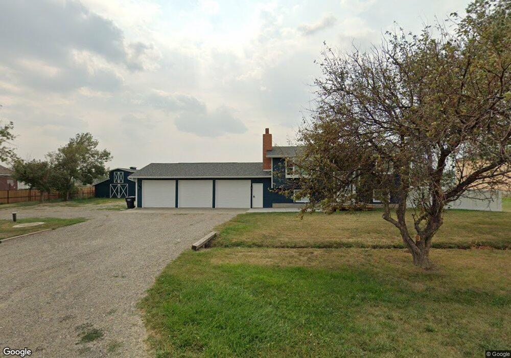
5632 Homer Davis Rd Shepherd, MT 59079
Estimated Value: $382,000 - $420,000
4
Beds
2
Baths
1,786
Sq Ft
$224/Sq Ft
Est. Value
About This Home
This home is located at 5632 Homer Davis Rd, Shepherd, MT 59079 and is currently estimated at $400,703, approximately $224 per square foot. 5632 Homer Davis Rd is a home located in Yellowstone County with nearby schools including Shepherd Elementary School, Shepherd Middle School, and Shepherd High School.
Ownership History
Date
Name
Owned For
Owner Type
Purchase Details
Closed on
Jun 7, 2021
Sold by
Kiedrowski Laura A and Bare Don
Bought by
Niedergger Hattie M and Studner Rodney
Current Estimated Value
Home Financials for this Owner
Home Financials are based on the most recent Mortgage that was taken out on this home.
Original Mortgage
$243,000
Outstanding Balance
$219,046
Interest Rate
2.9%
Mortgage Type
New Conventional
Estimated Equity
$181,657
Purchase Details
Closed on
Sep 6, 2005
Sold by
Arthur Richard J and Arthur Charlotte M
Bought by
Arthur Richard J and Arthur Charlotte M
Create a Home Valuation Report for This Property
The Home Valuation Report is an in-depth analysis detailing your home's value as well as a comparison with similar homes in the area
Purchase History
We collect this data history from publicly available records. To have your information removed, we recommend requesting removal directly through your county’s website.
| Date | Buyer | Sale Price | Title Company |
|---|---|---|---|
| Niedergger Hattie M | -- | Chicago Title | |
| Arthur Richard J | -- | None Available |
Source: Public Records
Mortgage History
We collect this data history from publicly available records. To have your information removed, we recommend requesting removal directly through your county’s website.
| Date | Status | Borrower | Loan Amount |
|---|---|---|---|
| Open | Niedergger Hattie M | $243,000 |
Source: Public Records
Tax History
| Year | Tax Paid | Tax Assessment Tax Assessment Total Assessment is a certain percentage of the fair market value that is determined by local assessors to be the total taxable value of land and additions on the property. | Land | Improvement |
|---|---|---|---|---|
| 2025 | $3,041 | $434,600 | $100,646 | $333,954 |
| 2024 | $3,041 | $351,600 | $75,843 | $275,757 |
| 2023 | $3,093 | $351,600 | $75,843 | $275,757 |
| 2022 | $2,585 | $274,900 | $0 | $0 |
| 2021 | $2,561 | $259,400 | $0 | $0 |
| 2020 | $2,549 | $249,700 | $0 | $0 |
| 2019 | $2,116 | $249,700 | $0 | $0 |
| 2018 | $2,060 | $228,400 | $0 | $0 |
| 2017 | $1,828 | $228,400 | $0 | $0 |
| 2016 | $1,940 | $228,700 | $0 | $0 |
| 2015 | $1,930 | $228,700 | $0 | $0 |
| 2014 | $1,516 | $95,718 | $0 | $0 |
Source: Public Records
Map
Nearby Homes
- 0 Shepherd Road Lot 2a Shepherd Rd
- 0 Shepherd Road Lot Shepherd Rd
- 6107 Shepherd Rd
- 6513 Frey Rd
- 5430 Cerkoney Ln
- 6447 US Highway 312
- 121 Peritse Ave
- 8020 Wade St
- 5213 Shepherd Acton Rd
- 1679 Jute St
- 7729 Buckskin Dr
- 3810 Homer Davis Rd
- 4780 Powmer Rd
- 7157 Lance St
- L5B4 Trumbo Cir
- L3B4 Trumbo Cir
- L11B3 High Noon Dr
- L13B2 High Noon Dr
- L4B4 Trumbo Cir
- L12B3 Molly Dr
- 5650 Homer Davis Rd
- 5620 Homer Davis Rd
- SHepherd Road lo Shepherd Rd
- 0 SHepherd Road lot Shepherd Rd
- 5706 Homer Davis Rd
- 6325 Shepherd Rd
- 6319 Shepherd Rd
- 5720 Homer Davis Rd
- 6324 Shepherd Rd
- 6406 Shepherd Rd
- 5734 Homer Davis Rd
- 5705 Silver Saddle Dr
- 5540 Edmunds Dr
- 5744 Homer Davis Rd
- 6435 Sauter Place
- 6420 Sauter Place
- 5515 Edmunds Dr
- 5625 Silver Saddle Dr
- 5635 Silver Saddle Dr
- 5603 Silver Saddle Dr
Your Personal Tour Guide
Ask me questions while you tour the home.