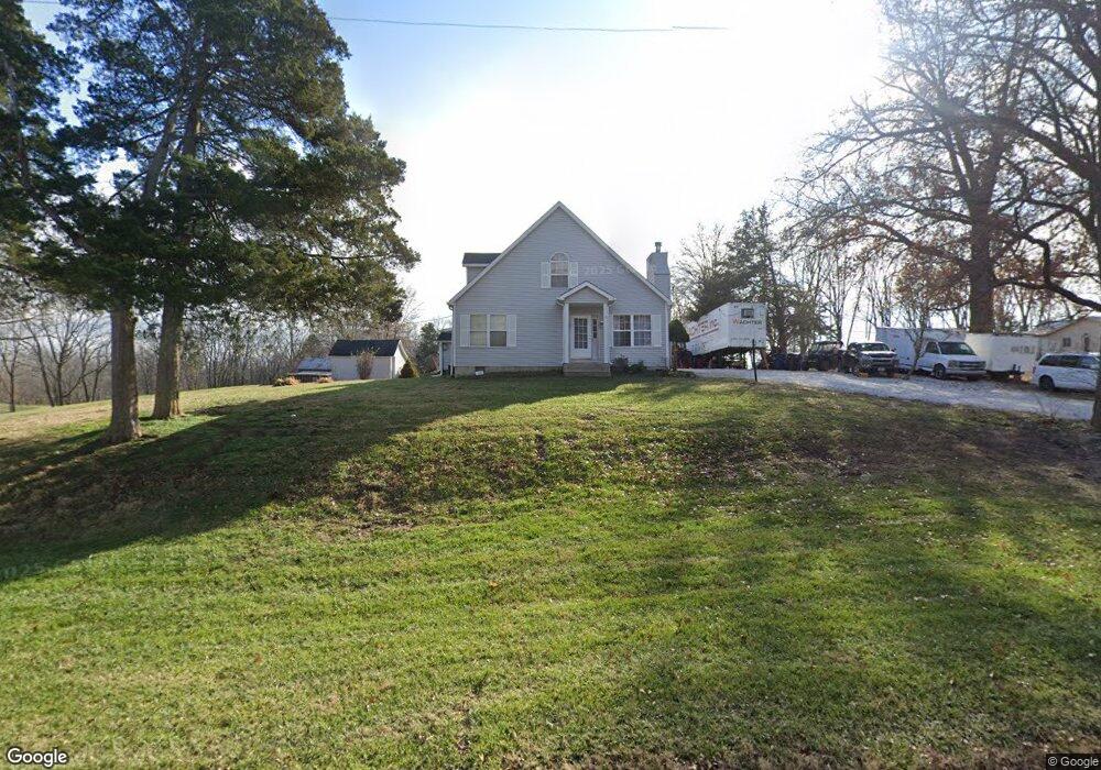
564 Jordan Rd Old Monroe, MO 63369
Estimated Value: $261,360 - $399,000
3
Beds
2
Baths
2,428
Sq Ft
$142/Sq Ft
Est. Value
About This Home
This home is located at 564 Jordan Rd, Old Monroe, MO 63369 and is currently estimated at $344,840, approximately $142 per square foot. 564 Jordan Rd is a home located in Lincoln County with nearby schools including Winfield Primary School, Winfield Intermediate School, and Winfield Middle School.
Ownership History
Date
Name
Owned For
Owner Type
Purchase Details
Closed on
Jan 3, 2008
Sold by
Roam John and Roam Sandra J
Bought by
Roam John and Roam Sandra J
Current Estimated Value
Home Financials for this Owner
Home Financials are based on the most recent Mortgage that was taken out on this home.
Original Mortgage
$195,000
Outstanding Balance
$122,767
Interest Rate
6.11%
Mortgage Type
New Conventional
Estimated Equity
$222,073
Create a Home Valuation Report for This Property
The Home Valuation Report is an in-depth analysis detailing your home's value as well as a comparison with similar homes in the area
Purchase History
| Date | Buyer | Sale Price | Title Company |
|---|---|---|---|
| Roam John | -- | None Available |
Source: Public Records
Mortgage History
| Date | Status | Borrower | Loan Amount |
|---|---|---|---|
| Open | Roam John | $195,000 |
Source: Public Records
Tax History
| Year | Tax Paid | Tax Assessment Tax Assessment Total Assessment is a certain percentage of the fair market value that is determined by local assessors to be the total taxable value of land and additions on the property. | Land | Improvement |
|---|---|---|---|---|
| 2025 | $1,343 | $24,594 | $4,150 | $20,444 |
| 2024 | $1,294 | $21,656 | $3,021 | $18,635 |
| 2023 | $1,288 | $21,656 | $3,021 | $18,635 |
| 2022 | $1,223 | $20,663 | $3,021 | $17,642 |
| 2021 | $1,229 | $108,750 | $0 | $0 |
| 2020 | $1,114 | $97,240 | $0 | $0 |
| 2019 | $1,116 | $97,240 | $0 | $0 |
| 2018 | $1,140 | $18,645 | $0 | $0 |
| 2017 | $1,144 | $18,645 | $0 | $0 |
| 2016 | $988 | $15,626 | $0 | $0 |
| 2015 | $992 | $15,626 | $0 | $0 |
| 2014 | $985 | $15,723 | $0 | $0 |
| 2013 | -- | $14,261 | $0 | $0 |
Source: Public Records
Map
Nearby Homes
- 101 Sunrise Ln
- 2140 Flatwoods Rd
- 244 Autumn Hallow Ct
- 232 Autumn Hallow Ct
- 238 Autumn Hallow Ct
- 239 Autumn Hallow Ct
- 220 Autumn Hallow Ct
- 250 Autumn Hallow Ct
- 251 Autumn Hallow Ct
- 102 Harvest Glen Ct
- 214 Autumn Hallow Ct
- 108 Harvest Glen Ct
- 103 Harvest Glen Ct
- 114 Harvest Glen Ct
- 109 Harvest Glen Ct
- 523 Saint John Ln
- 0000 Old Setter Rd
- 0 Old Setter Rd
- 261 Bless Us Dr E
- 4 Slate River Way
Your Personal Tour Guide
Ask me questions while you tour the home.