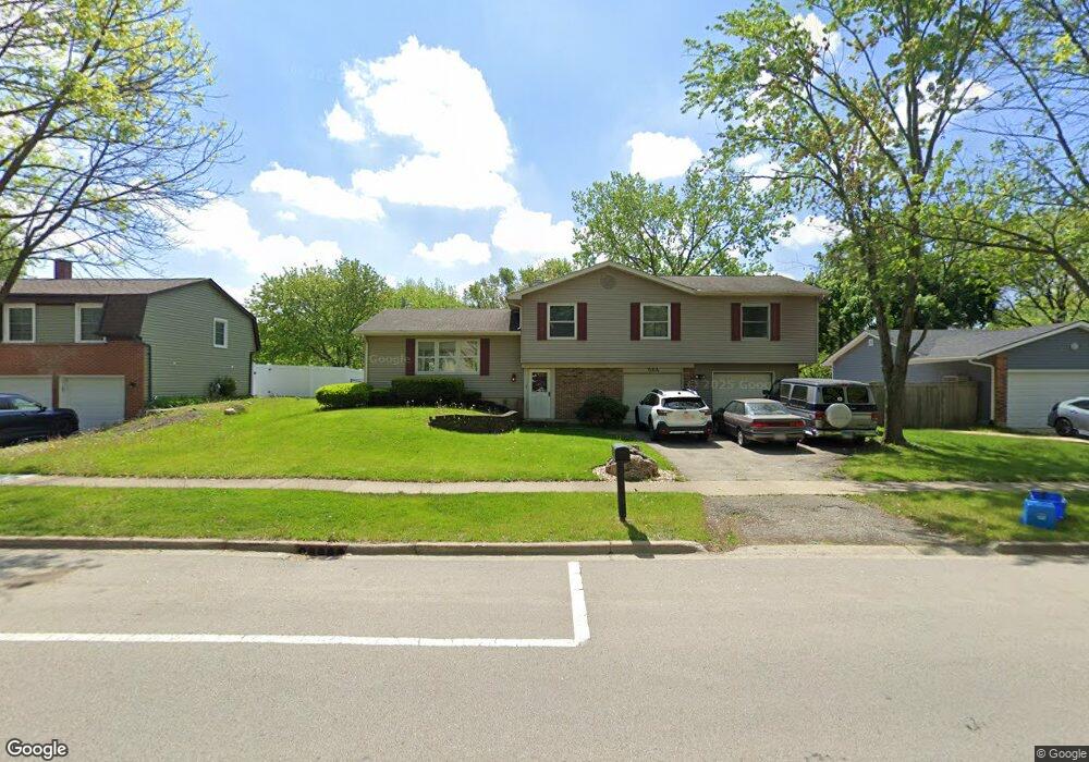
564 N Pinecrest Rd Bolingbrook, IL 60440
East Bolingbrook NeighborhoodEstimated Value: $331,654 - $416,000
3
Beds
2
Baths
1,939
Sq Ft
$195/Sq Ft
Est. Value
About This Home
This home is located at 564 N Pinecrest Rd, Bolingbrook, IL 60440 and is currently estimated at $377,664, approximately $194 per square foot. 564 N Pinecrest Rd is a home located in Will County with nearby schools including Jonas E Salk Elementary School, Hubert H Humphrey Middle School, and Brooks Middle School.
Ownership History
Date
Name
Owned For
Owner Type
Purchase Details
Closed on
Nov 10, 2006
Sold by
Sanders William J and Sanders Debra
Bought by
Sanders William J
Current Estimated Value
Home Financials for this Owner
Home Financials are based on the most recent Mortgage that was taken out on this home.
Original Mortgage
$185,000
Outstanding Balance
$111,021
Interest Rate
6.47%
Mortgage Type
New Conventional
Estimated Equity
$266,643
Purchase Details
Closed on
Aug 6, 1987
Bought by
Sanders William
Create a Home Valuation Report for This Property
The Home Valuation Report is an in-depth analysis detailing your home's value as well as a comparison with similar homes in the area
Home Values in the Area
Average Home Value in this Area
Purchase History
| Date | Buyer | Sale Price | Title Company |
|---|---|---|---|
| Sanders William J | -- | Greater Illinois Title Compa | |
| Sanders William | $76,000 | -- |
Source: Public Records
Mortgage History
| Date | Status | Borrower | Loan Amount |
|---|---|---|---|
| Open | Sanders William J | $185,000 |
Source: Public Records
Tax History
| Year | Tax Paid | Tax Assessment Tax Assessment Total Assessment is a certain percentage of the fair market value that is determined by local assessors to be the total taxable value of land and additions on the property. | Land | Improvement |
|---|---|---|---|---|
| 2024 | $8,262 | $97,463 | $19,228 | $78,235 |
| 2023 | $8,262 | $87,694 | $17,301 | $70,393 |
| 2022 | $7,222 | $79,061 | $15,598 | $63,463 |
| 2021 | $6,838 | $73,923 | $14,584 | $59,339 |
| 2020 | $6,624 | $71,492 | $14,104 | $57,388 |
| 2019 | $6,406 | $68,087 | $13,432 | $54,655 |
| 2018 | $6,145 | $65,167 | $12,856 | $52,311 |
| 2017 | $5,845 | $61,770 | $12,186 | $49,584 |
| 2016 | $5,670 | $58,800 | $11,600 | $47,200 |
| 2015 | $5,083 | $56,400 | $11,100 | $45,300 |
| 2014 | $5,083 | $56,400 | $11,100 | $45,300 |
| 2013 | $5,083 | $53,200 | $10,500 | $42,700 |
Source: Public Records
Map
Nearby Homes
- 598 Miner Dr
- 428 N Ashbury Ave
- 505 Goodwin Dr
- 7 Purchase Ct
- 409 N Ashbury Ave
- 704 N Pinecrest Rd
- 221 Monroe Rd Unit 8
- 424 Van Gogh Cir Unit 1
- 513 Jill Ln
- 168 Winston Dr
- 775 Feather Sound Dr
- 156 Winston Dr
- 473 Rockhurst Rd
- 574 Norman Rd
- 488 Ridge Ln
- 490 Ridge Ln
- 492 Ridge Ln
- 462 Ridge Ln
- 325 Rockhurst Rd
- 535 Jordan Way
- 568 N Pinecrest Rd Unit 5
- 560 N Pinecrest Rd Unit 5
- 572 N Pinecrest Rd
- 579 Cades Ct Unit 5
- 570 Miner Dr
- 450 Alcester Ct
- 576 N Pinecrest Rd
- 583 Cades Ct
- 586 Cades Ct
- 571 Miner Dr
- 574 Miner Dr
- 579 N Pinecrest Rd
- 587 Cades Ct
- 580 N Pinecrest Rd
- 454 Alcester Ct
- 590 Cades Ct Unit 5
- 442 Alcester Ct
- 583 N Pinecrest Rd
- 575 Miner Dr
- 578 Miner Dr
Your Personal Tour Guide
Ask me questions while you tour the home.