Estimated Value: $355,359 - $422,000
3
Beds
3
Baths
1,786
Sq Ft
$221/Sq Ft
Est. Value
About This Home
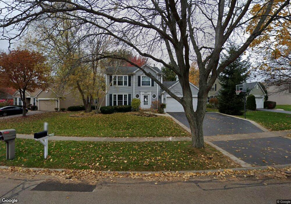
This home is located at 564 Surrey Ridge Dr, Cary, IL 60013 and is currently estimated at $395,090, approximately $221 per square foot. 564 Surrey Ridge Dr is a home located in McHenry County with nearby schools including Briargate Elementary School, Cary Jr High School, and Cary-Grove High School.
Ownership History
Date
Name
Owned For
Owner Type
Purchase Details
Closed on
Feb 28, 2020
Sold by
Lemke Jeffrey D and Lemke Patricia
Bought by
Lemke Jeffrey and Lemke Patricia
Current Estimated Value
Purchase Details
Closed on
Jun 21, 1996
Sold by
Vanleirsburg Richard G and Vanleirsburg Terrie A
Bought by
Lemke Jeffrey A and Lemke Patricia
Purchase Details
Closed on
Jun 2, 1994
Sold by
Gilde Steven E and Gilde Peggy
Bought by
Vanleirsburg Richard G and Vanleirsburg Terrie A
Home Financials for this Owner
Home Financials are based on the most recent Mortgage that was taken out on this home.
Original Mortgage
$42,000
Interest Rate
8.45%
Create a Home Valuation Report for This Property
The Home Valuation Report is an in-depth analysis detailing your home's value as well as a comparison with similar homes in the area
Home Values in the Area
Average Home Value in this Area
Purchase History
| Date | Buyer | Sale Price | Title Company |
|---|---|---|---|
| Lemke Jeffrey | -- | Attorney | |
| Lemke Jeffrey A | $173,000 | -- | |
| Vanleirsburg Richard G | $164,000 | Attorneys Title Guaranty Fun |
Source: Public Records
Mortgage History
| Date | Status | Borrower | Loan Amount |
|---|---|---|---|
| Previous Owner | Vanleirsburg Richard G | $42,000 |
Source: Public Records
Tax History
| Year | Tax Paid | Tax Assessment Tax Assessment Total Assessment is a certain percentage of the fair market value that is determined by local assessors to be the total taxable value of land and additions on the property. | Land | Improvement |
|---|---|---|---|---|
| 2024 | $7,792 | $100,532 | $8,924 | $91,608 |
| 2023 | $7,582 | $89,913 | $7,981 | $81,932 |
| 2022 | $7,488 | $85,969 | $9,065 | $76,904 |
| 2021 | $7,129 | $80,090 | $8,445 | $71,645 |
| 2020 | $6,914 | $77,255 | $8,146 | $69,109 |
| 2019 | $6,773 | $73,943 | $7,797 | $66,146 |
| 2018 | $7,038 | $74,783 | $17,404 | $57,379 |
| 2017 | $6,897 | $70,451 | $16,396 | $54,055 |
| 2016 | $6,840 | $66,077 | $15,378 | $50,699 |
| 2013 | -- | $58,507 | $14,345 | $44,162 |
Source: Public Records
Map
Nearby Homes
- 515 Surrey Ridge Dr
- 550 Enclave Dr
- 425 Haber Rd Unit 6
- 421 Haber Rd Unit 7
- 417 Haber Rd Unit 6
- 413 Haber Rd Unit 5
- 256 Haber Ct
- 29 Ivanhoe Ln
- 204 Country Commons Rd
- 9416 3rd Ave
- 55 Duxbury Ln
- 9620 Fox Shores Dr
- 800 Big Bear Trail
- 1259 Chickory Ridge Trail
- 418 Glen Garry Rd
- 1387 New Haven Dr
- 103 S Seebert St Unit 1
- 0 Kaper Dr
- 550 Norman Dr
- 3712 3 Oaks Rd
- 554 Surrey Ridge Dr
- 574 Surrey Ridge Dr
- 534 Surrey Ridge Dr
- 5 Applewood Ct
- 569 Surrey Ridge Dr
- 21 Deerpath Ct
- 575 Surrey Ridge Dr
- 559 Surrey Ridge Dr
- 565 Surrey Ridge Dr
- 7 Applewood Ct
- 19 Deerpath Ct
- 555 Surrey Ridge Dr
- 549 Surrey Ridge Dr
- 609 Surrey Ridge Dr
- 3 Applewood Ct
- 3 Applewood Ct
- 17 Deerpath Ct
- 8 Muirwood Ct
- 9 Applewood Ct
- 6 Muirwood Ct
Your Personal Tour Guide
Ask me questions while you tour the home.