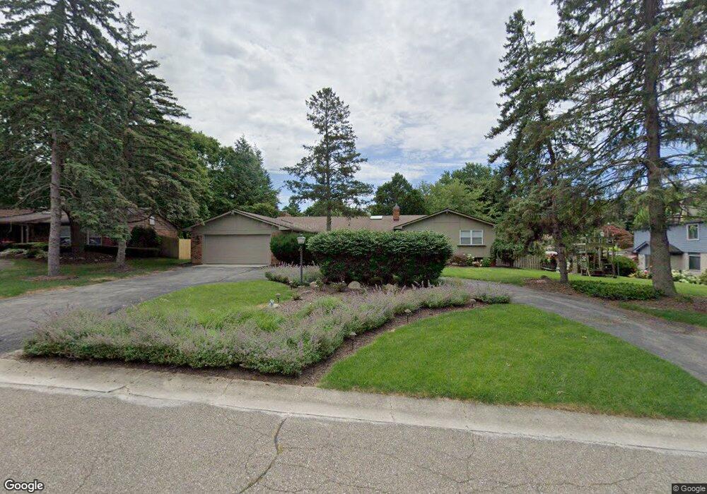
5645 Apple Ridge Trail West Bloomfield, MI 48322
Estimated Value: $488,020 - $647,000
4
Beds
3
Baths
2,674
Sq Ft
$213/Sq Ft
Est. Value
About This Home
This home is located at 5645 Apple Ridge Trail, West Bloomfield, MI 48322 and is currently estimated at $568,505, approximately $212 per square foot. 5645 Apple Ridge Trail is a home located in Oakland County with nearby schools including Sheiko Elementary School, West Bloomfield Middle School, and Brookfield Academy - West Bloomfield Campus.
Ownership History
Date
Name
Owned For
Owner Type
Purchase Details
Closed on
Sep 9, 2010
Sold by
Woodward Asset Capital Llc
Bought by
Rhode Jesena and Jesena Carol
Current Estimated Value
Purchase Details
Closed on
Sep 15, 2009
Sold by
Neal Edward
Bought by
Federal Home Loan Mortgage Corp
Purchase Details
Closed on
Jul 11, 2007
Sold by
Us Bank Na
Bought by
Neal Edward
Purchase Details
Closed on
Feb 21, 2006
Sold by
Bartell Gerald W and Bartell Carol A
Bought by
U S Bank National Association
Create a Home Valuation Report for This Property
The Home Valuation Report is an in-depth analysis detailing your home's value as well as a comparison with similar homes in the area
Home Values in the Area
Average Home Value in this Area
Purchase History
| Date | Buyer | Sale Price | Title Company |
|---|---|---|---|
| Rhode Jesena | $229,000 | None Available | |
| Federal Home Loan Mortgage Corp | $132,000 | None Available | |
| Neal Edward | $227,115 | Rels Title | |
| U S Bank National Association | $441,312 | None Available |
Source: Public Records
Tax History Compared to Growth
Tax History
| Year | Tax Paid | Tax Assessment Tax Assessment Total Assessment is a certain percentage of the fair market value that is determined by local assessors to be the total taxable value of land and additions on the property. | Land | Improvement |
|---|---|---|---|---|
| 2024 | $3,125 | $185,890 | $0 | $0 |
| 2022 | $2,993 | $168,320 | $36,480 | $131,840 |
| 2021 | $4,548 | $158,650 | $0 | $0 |
| 2020 | $2,933 | $149,450 | $36,480 | $112,970 |
| 2018 | $4,384 | $146,480 | $36,480 | $110,000 |
| 2015 | -- | $122,290 | $0 | $0 |
| 2014 | -- | $113,910 | $0 | $0 |
| 2011 | -- | $103,730 | $0 | $0 |
Source: Public Records
Map
Nearby Homes
- 5622 Powder Horn Dr
- 5780 Swan Lake Ct
- 5415 Fairway Ln
- 5321 Fairway Ln Unit 7
- 3104 Spring St
- 3865 Stonecrest Rd
- 3035 Parkland Dr
- 3930 Harris Ln
- 6151 Orchard Lake Rd Unit 103
- 6109 Orchard Lake Rd Unit 101
- 6145 Orchard Lake Rd Unit 204
- 5352 W Doherty Dr
- 3961 Will O Way Ln
- 4117 Marlwood Dr
- 4163 Autumn Ridge Dr
- 4941 Fairway Ridge Cir
- 5946 Cherry Crest Dr
- 5815 Bloomfield Glens Rd
- 6322 Pepper Hill St Unit 62
- 6222 Pepper Hill St
- 5633 Apple Ridge Trail
- 5637 Swan Lake Dr
- 5658 Powder Horn Dr
- 5651 Swan Lake Dr
- 5646 Powder Horn Dr
- 5621 Apple Ridge Trail
- 5611 Swan Lake Dr
- 5644 Apple Ridge Trail
- 5626 Apple Ridge Trail
- 5636 Swan Lake Dr
- 5648 Swan Lake Dr
- 5594 Apple Ridge Trail
- 5665 Powder Horn Dr
- 5591 Swan Lake Dr
- 5660 Swan Lake Dr
- 5703 Swan Lake Dr
- 5612 Swan Lake Dr
- 5641 Powder Horn Dr
- 5598 Powder Horn Dr
- 5576 Apple Ridge Trail