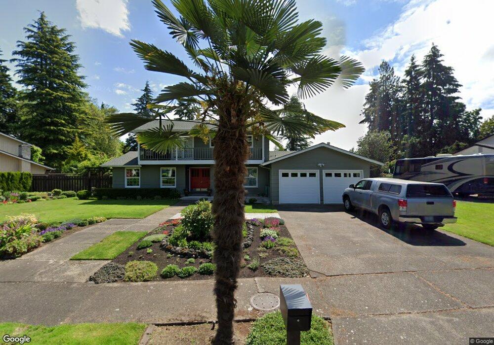
565 Merewether St Eugene, OR 97401
Harlow NeighborhoodEstimated Value: $584,000 - $728,174
5
Beds
3
Baths
2,322
Sq Ft
$290/Sq Ft
Est. Value
About This Home
This home is located at 565 Merewether St, Eugene, OR 97401 and is currently estimated at $673,044, approximately $289 per square foot. 565 Merewether St is a home located in Lane County with nearby schools including Holt Elementary School, Monroe Middle School, and Sheldon High School.
Ownership History
Date
Name
Owned For
Owner Type
Purchase Details
Closed on
Jan 16, 2018
Sold by
Polsky Stanley and Polsky Bernice
Bought by
Polsky Family Revocable Trust and Polsky
Current Estimated Value
Purchase Details
Closed on
Oct 6, 2017
Sold by
Posky Stanley and Posky Bernice
Bought by
Posky Stanley and Posky Bernice
Purchase Details
Closed on
Jul 28, 2015
Sold by
Hochstein Michael L and Hochstein Deanna Gamel
Bought by
Ward Patrick G and Ward Kathleen M
Create a Home Valuation Report for This Property
The Home Valuation Report is an in-depth analysis detailing your home's value as well as a comparison with similar homes in the area
Home Values in the Area
Average Home Value in this Area
Purchase History
| Date | Buyer | Sale Price | Title Company |
|---|---|---|---|
| Polsky Family Revocable Trust | -- | None Listed On Document | |
| Posky Stanley | -- | None Available | |
| Ward Patrick G | $376,900 | Western Title & Escrow Co |
Source: Public Records
Tax History
| Year | Tax Paid | Tax Assessment Tax Assessment Total Assessment is a certain percentage of the fair market value that is determined by local assessors to be the total taxable value of land and additions on the property. | Land | Improvement |
|---|---|---|---|---|
| 2025 | $7,757 | $398,109 | -- | -- |
| 2024 | $7,660 | $386,514 | -- | -- |
| 2023 | $7,660 | $375,257 | -- | -- |
| 2022 | $7,176 | $364,328 | $0 | $0 |
| 2021 | $6,740 | $353,717 | $0 | $0 |
| 2020 | $6,743 | $343,415 | $0 | $0 |
| 2019 | $6,411 | $333,413 | $0 | $0 |
| 2018 | $6,004 | $314,274 | $0 | $0 |
| 2017 | $5,684 | $314,274 | $0 | $0 |
| 2016 | $5,507 | $305,120 | $0 | $0 |
| 2015 | $5,324 | $296,233 | $0 | $0 |
| 2014 | $5,153 | $287,605 | $0 | $0 |
Source: Public Records
Map
Nearby Homes
- 3360 Chevy Chase St
- 835 Anderson Ln
- 1130 Anderson Ln
- 2646 Cascara Dr
- 2642 Cascara Dr
- 1505 Canal St
- 3579 Oxbow Way
- 1074 Hamilton St
- 2709 E 16th Ave
- 2770 E 16th Ave
- 1650 Augusta Aly
- 1652 Augusta Aly
- 0 Sylvan St Unit 247715494
- 1702 Augusta St
- 275 Sunset Dr
- 280 Regal Ct
- 446 Kodiak St
- 1867 Fircrest Dr
- 2994 Dapple Way
- 1993 Fircrest Dr
- 525 Merewether St
- 585 Merewether St
- 3430 Chevy Chase St
- 3440 Chevy Chase St
- 3395 Buckingham Ave
- 3398 Buckingham Ave
- 3425 Bardell Ave
- 3435 Bardell Ave
- 3396 Chevy Chase St
- 3445 Bardell Ave
- 592 Merewether St
- 3380 Buckingham Ave
- 3460 Chevy Chase St
- 3405 Chevy Chase St
- 3379 Buckingham Ave
- 3425 Chevy Chase St
- 3385 Bardell Ave
- 3455 Bardell Ave
- 3445 Chevy Chase St
- 3386 Chevy Chase St
Your Personal Tour Guide
Ask me questions while you tour the home.