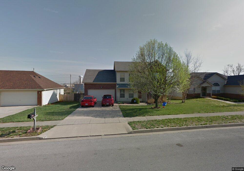
565 Southbrook Dr Nicholasville, KY 40356
South Nicholasville NeighborhoodEstimated Value: $265,000 - $338,000
4
Beds
3
Baths
1,980
Sq Ft
$155/Sq Ft
Est. Value
About This Home
This home is located at 565 Southbrook Dr, Nicholasville, KY 40356 and is currently estimated at $307,359, approximately $155 per square foot. 565 Southbrook Dr is a home located in Jessamine County with nearby schools including Nicholasville Elementary School, West Jessamine Middle School, and West Jessamine High School.
Ownership History
Date
Name
Owned For
Owner Type
Purchase Details
Closed on
Jun 29, 2018
Sold by
Defilippo Michael A and Defilippo Lisa M
Bought by
Marcum Tabitha and Marcum Michael
Current Estimated Value
Home Financials for this Owner
Home Financials are based on the most recent Mortgage that was taken out on this home.
Original Mortgage
$102,000
Outstanding Balance
$88,594
Interest Rate
4.6%
Mortgage Type
New Conventional
Estimated Equity
$218,765
Create a Home Valuation Report for This Property
The Home Valuation Report is an in-depth analysis detailing your home's value as well as a comparison with similar homes in the area
Home Values in the Area
Average Home Value in this Area
Purchase History
| Date | Buyer | Sale Price | Title Company |
|---|---|---|---|
| Marcum Tabitha | $172,000 | Clear Title |
Source: Public Records
Mortgage History
| Date | Status | Borrower | Loan Amount |
|---|---|---|---|
| Open | Marcum Tabitha | $102,000 |
Source: Public Records
Tax History Compared to Growth
Tax History
| Year | Tax Paid | Tax Assessment Tax Assessment Total Assessment is a certain percentage of the fair market value that is determined by local assessors to be the total taxable value of land and additions on the property. | Land | Improvement |
|---|---|---|---|---|
| 2024 | $2,171 | $206,400 | $36,000 | $170,400 |
| 2023 | $2,192 | $206,400 | $36,000 | $170,400 |
| 2022 | $320 | $172,000 | $30,000 | $142,000 |
| 2021 | $320 | $172,000 | $30,000 | $142,000 |
| 2020 | $320 | $172,000 | $30,000 | $142,000 |
| 2019 | $320 | $172,000 | $30,000 | $142,000 |
| 2018 | $270 | $145,000 | $30,000 | $115,000 |
| 2017 | $270 | $145,000 | $30,000 | $115,000 |
| 2016 | $1,462 | $145,000 | $30,000 | $115,000 |
| 2015 | $1,462 | $145,000 | $30,000 | $115,000 |
| 2014 | $1,437 | $145,000 | $30,000 | $115,000 |
Source: Public Records
Map
Nearby Homes
- lot 13 Wild Turkey Ct
- 205 Southside Way
- 405 Weslyn Way
- 356 Weslyn Way
- 101 E Ridge Dr
- lot 10 Wild Turkey Ct
- 429 Southbrook Dr
- 405 Southbrook Dr Unit 405 Southbrook Drive
- 124 Farmers Bluff
- 117 Farmers Bluff
- 121 Farmers Bluff
- 117 Peoples Meadow
- lot 20 Crawford Creek Dr
- 105 Peoples Meadow
- lot 4 Crawford Creek Dr
- 224 San Antonio Way
- 102 Briarwood Dr
- lot 1 Crawford Creek Dr
- 104 Growers Field
- Imperial Plan at Burley Ridge
- 561 Southbrook Dr
- 569 Southbrook Dr
- 573 Southbrook Dr
- 560 Southbrook Dr
- 564 Southbrook Dr
- 556 Southbrook Dr
- 553 Southbrook Dr
- 577 Southbrook Dr
- 568 Southbrook Dr
- 552 Southbrook Dr
- 549 Southbrook Dr
- 581 Southbrook Dr Unit 2B
- 572 Southbrook Dr
- 548 Southbrook Dr
- 221 Ridgecrest Dr
- 221 Ridge Crest Dr
- 217 Ridgecrest Dr
- 225 Ridge Crest Dr
- 225 Ridgecrest Dr
- 217 Ridge Crest Dr