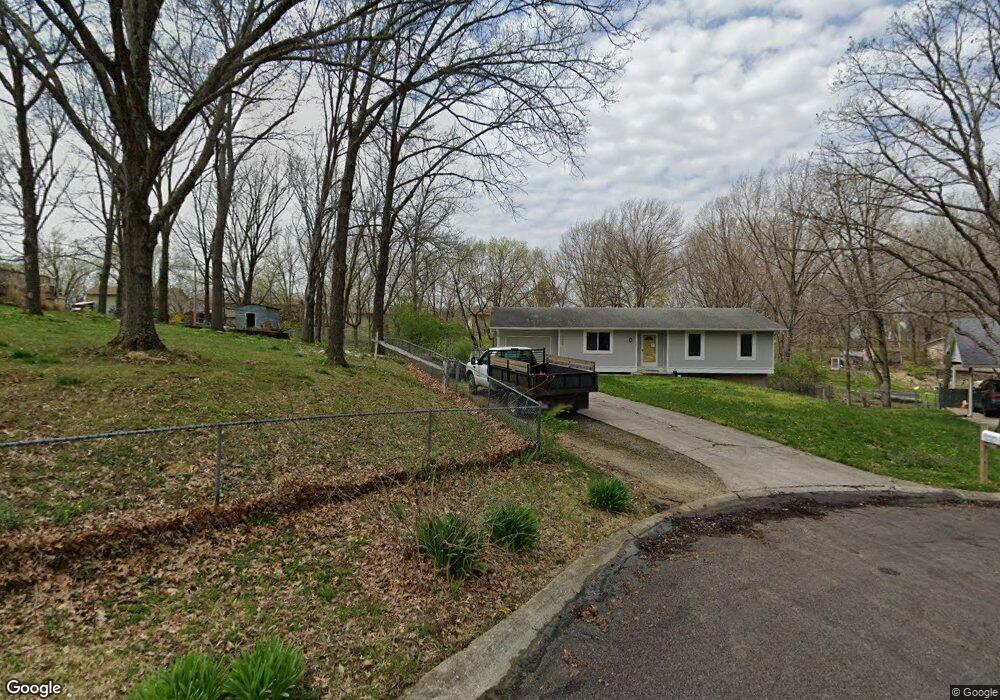
5658 N Maple Ct Columbia, MO 65202
Estimated Value: $229,000 - $247,000
3
Beds
2
Baths
2,088
Sq Ft
$115/Sq Ft
Est. Value
About This Home
This home is located at 5658 N Maple Ct, Columbia, MO 65202 and is currently estimated at $239,644, approximately $114 per square foot. 5658 N Maple Ct is a home located in Boone County with nearby schools including Parkade Elementary School, Smithton Middle School, and David H. Hickman High School.
Ownership History
Date
Name
Owned For
Owner Type
Purchase Details
Closed on
Oct 5, 2022
Sold by
Leisinger Keaton E and Leisinger Sierra M
Bought by
Keaton And Sierra Leisinger Family Trust
Current Estimated Value
Purchase Details
Closed on
May 16, 2019
Sold by
Williams George F and Williams Linda C
Bought by
Leisinger Keaton and Leisinger Sierra
Home Financials for this Owner
Home Financials are based on the most recent Mortgage that was taken out on this home.
Original Mortgage
$144,444
Interest Rate
4%
Mortgage Type
New Conventional
Create a Home Valuation Report for This Property
The Home Valuation Report is an in-depth analysis detailing your home's value as well as a comparison with similar homes in the area
Purchase History
| Date | Buyer | Sale Price | Title Company |
|---|---|---|---|
| Keaton And Sierra Leisinger Family Trust | -- | -- | |
| Leisinger Keaton | -- | Boone Central Title Company |
Source: Public Records
Mortgage History
| Date | Status | Borrower | Loan Amount |
|---|---|---|---|
| Previous Owner | Leisinger Keaton | $144,444 |
Source: Public Records
Tax History
| Year | Tax Paid | Tax Assessment Tax Assessment Total Assessment is a certain percentage of the fair market value that is determined by local assessors to be the total taxable value of land and additions on the property. | Land | Improvement |
|---|---|---|---|---|
| 2025 | $1,694 | $24,092 | $2,394 | $21,698 |
| 2024 | $1,584 | $21,907 | $2,394 | $19,513 |
| 2023 | $1,571 | $21,907 | $2,394 | $19,513 |
| 2022 | $1,454 | $20,292 | $2,394 | $17,898 |
| 2021 | $1,456 | $20,292 | $2,394 | $17,898 |
| 2020 | $1,377 | $18,118 | $2,394 | $15,724 |
| 2019 | $1,378 | $18,118 | $2,394 | $15,724 |
| 2018 | $1,284 | $0 | $0 | $0 |
| 2017 | $1,269 | $16,777 | $2,394 | $14,383 |
| 2016 | $1,267 | $16,777 | $2,394 | $14,383 |
| 2015 | $1,170 | $16,777 | $2,394 | $14,383 |
| 2014 | -- | $16,777 | $2,394 | $14,383 |
Source: Public Records
Map
Nearby Homes
- 5335 N Rocky Fork Dr
- L401-L430 Forest Ridge Plat 4
- 154 E Tully Ct
- 5304 Aspen Ridge Dr
- LOT 22 Lookout Peak Dr
- L22 Lookout Peak Dr
- L23 Lookout Peak Dr
- LOT 18 Lookout Peak Dr
- 4980 N Irvin Loop
- LOT 70 Aspen Ridge Dr
- 0 N Highway Vv
- 5280 N Burning Bush Rd
- 5281 N Burning Bush Rd
- 5041 N Jasmine Way
- 6131 N Wagon Trail Rd
- 5171 N Creasy Springs Rd
- LOT 502 Sullivan St
- LOT 239 Peregrine Place
- LOT 143 Sullivan St
- LOT 225 Chancellor Cir
- 5669 N Maple Ct
- 5657 N Maple Ct
- 5697 N Maple Ct
- 5739 S Cedar Ct
- 5644 N Rocky Fork Dr
- 5660 N Rocky Fork Dr
- 5628 N Rocky Fork Dr
- 5676 N Rocky Fork Dr
- 5635 N Maple Ct
- 5617 N Maple Ct
- 5740 S Cedar Ct
- 5612 N Rocky Fork Dr
- 5692 N Rocky Fork Dr
- 5714 N Maple Ct
- 5759 S Cedar Ct
- 63 S Cedar Ct
- 5700 N Maple Ct
- 5678 N Maple Ct
- 5601 N Maple Ct
- 5654 N Maple Ct
Your Personal Tour Guide
Ask me questions while you tour the home.