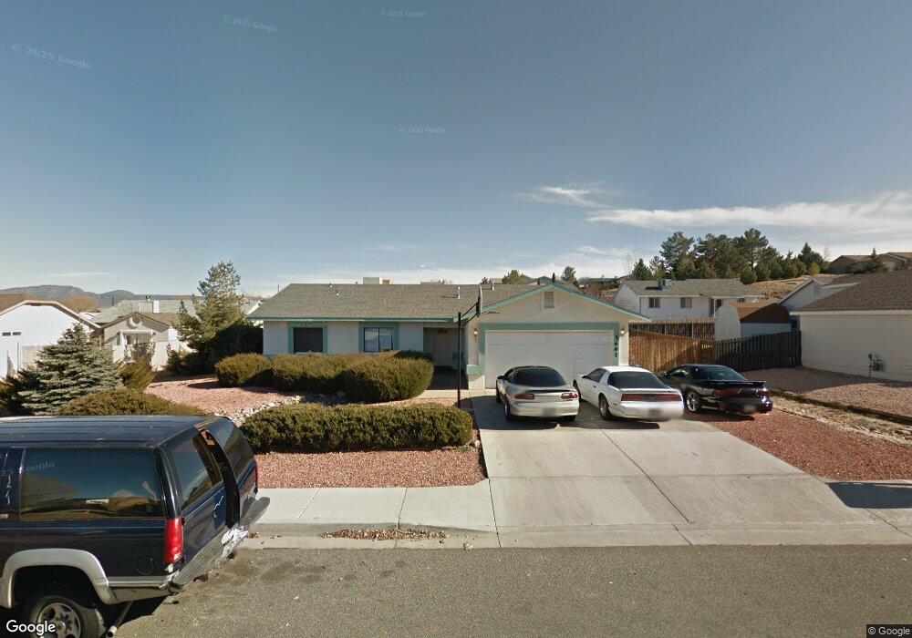
5661 N Mission Ln Prescott Valley, AZ 86314
Estimated Value: $394,000 - $459,000
4
Beds
2
Baths
1,737
Sq Ft
$244/Sq Ft
Est. Value
About This Home
This home is located at 5661 N Mission Ln, Prescott Valley, AZ 86314 and is currently estimated at $423,320, approximately $243 per square foot. 5661 N Mission Ln is a home located in Yavapai County with nearby schools including Coyote Springs Elementary School, Glassford Hill Middle School, and Bradshaw Mountain High School.
Ownership History
Date
Name
Owned For
Owner Type
Purchase Details
Closed on
May 28, 2024
Sold by
Alan Takuo Egusa Trust and Egusa Alan Takuo
Bought by
Egusa Dane
Current Estimated Value
Purchase Details
Closed on
Jul 26, 2004
Sold by
Egusa Alan
Bought by
Egusa Alan T and The Alan Takuo Egusa Trust
Home Financials for this Owner
Home Financials are based on the most recent Mortgage that was taken out on this home.
Original Mortgage
$112,500
Interest Rate
6.29%
Mortgage Type
Trade
Create a Home Valuation Report for This Property
The Home Valuation Report is an in-depth analysis detailing your home's value as well as a comparison with similar homes in the area
Home Values in the Area
Average Home Value in this Area
Purchase History
| Date | Buyer | Sale Price | Title Company |
|---|---|---|---|
| Egusa Dane | -- | None Listed On Document | |
| Egusa Alan T | -- | Chicago Title Ins Co | |
| Egusa Alan T | $150,000 | Chicago Title Ins Co |
Source: Public Records
Mortgage History
| Date | Status | Borrower | Loan Amount |
|---|---|---|---|
| Previous Owner | Egusa Alan T | $112,500 |
Source: Public Records
Tax History Compared to Growth
Tax History
| Year | Tax Paid | Tax Assessment Tax Assessment Total Assessment is a certain percentage of the fair market value that is determined by local assessors to be the total taxable value of land and additions on the property. | Land | Improvement |
|---|---|---|---|---|
| 2026 | $1,808 | $35,451 | -- | -- |
| 2024 | $1,677 | $37,227 | -- | -- |
| 2023 | $1,677 | $30,987 | $4,168 | $26,819 |
| 2022 | $1,650 | $25,064 | $2,868 | $22,196 |
| 2021 | $1,694 | $23,187 | $2,883 | $20,304 |
| 2020 | $1,635 | $0 | $0 | $0 |
| 2019 | $1,613 | $0 | $0 | $0 |
| 2018 | $1,543 | $0 | $0 | $0 |
| 2017 | $1,512 | $0 | $0 | $0 |
| 2016 | $1,464 | $0 | $0 | $0 |
| 2015 | -- | $0 | $0 | $0 |
| 2014 | -- | $0 | $0 | $0 |
Source: Public Records
Map
Nearby Homes
- 5575 E Magpie Dr
- 8620 E Crater Ct
- 5681 N Hondo Dr
- 5344 N Cord Dr
- 5601 N Robert Rd
- 8517 Roundup Dr
- 8501 Roundup Dr
- 8485 Roundup Dr
- 5244 N Pinto Dr
- 5080 N Ranger Rd
- 5290 N Robert Rd
- 5445 N Mesquite Dr
- 9101 E Manley Dr
- 5088 N Desert Ln
- 8428 E Manley Dr
- 8061 E Dust Devil Dr
- 8061 E Dust Devil Dr Unit 5681
- 5414 N Wickiup Rd
- 4870 N Meixner Rd Unit 4
- 5035 N Robert Rd
- 5681 N Mission Ln
- 5641 N Mission Ln
- 5650 N Pawnee Dr
- 5626 N Pawnee Dr
- 5676 N Pawnee Dr
- 5670 N Mission Ln
- 5650 N Mission Ln
- 5701 N Mission Ln
- 5700 N Mission Ln Unit 9
- 5700 N Mission Ln
- 5600 N Pawnee Dr
- 5630 N Mission Ln Unit 9
- 5700 N Pawnee Dr
- 5649 N Squaw Dr
- 5649 N Squaw Dr Unit 9
- 5651 N Pawnee Dr
- 8866 E Nugget Cir
- 8866 E Nugget Cir Unit 9
- 5675 N Squaw Dr
- 5625 N Squaw Dr