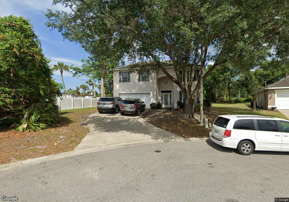
567 Elmcrest Place Debary, FL 32713
Estimated Value: $424,000 - $476,078
4
Beds
3
Baths
2,641
Sq Ft
$171/Sq Ft
Est. Value
About This Home
This home is located at 567 Elmcrest Place, Debary, FL 32713 and is currently estimated at $450,520, approximately $170 per square foot. 567 Elmcrest Place is a home located in Volusia County with nearby schools including Debary Elementary School, River Springs Middle School, and University High School.
Ownership History
Date
Name
Owned For
Owner Type
Purchase Details
Closed on
May 20, 1999
Sold by
Today Homes Inc
Bought by
Nathan Ronald J and Nathan Ingrid C
Current Estimated Value
Home Financials for this Owner
Home Financials are based on the most recent Mortgage that was taken out on this home.
Original Mortgage
$161,401
Outstanding Balance
$41,116
Interest Rate
6.87%
Mortgage Type
VA
Estimated Equity
$409,404
Purchase Details
Closed on
Jul 17, 1996
Sold by
Volusia 17-92 Ptnr
Bought by
Dept Of Transportation
Create a Home Valuation Report for This Property
The Home Valuation Report is an in-depth analysis detailing your home's value as well as a comparison with similar homes in the area
Home Values in the Area
Average Home Value in this Area
Purchase History
| Date | Buyer | Sale Price | Title Company |
|---|---|---|---|
| Nathan Ronald J | $31,800 | -- | |
| Dept Of Transportation | -- | -- |
Source: Public Records
Mortgage History
| Date | Status | Borrower | Loan Amount |
|---|---|---|---|
| Open | Nathan Ronald J | $161,401 |
Source: Public Records
Tax History Compared to Growth
Tax History
| Year | Tax Paid | Tax Assessment Tax Assessment Total Assessment is a certain percentage of the fair market value that is determined by local assessors to be the total taxable value of land and additions on the property. | Land | Improvement |
|---|---|---|---|---|
| 2025 | $2,191 | $168,249 | -- | -- |
| 2024 | $2,191 | $163,508 | -- | -- |
| 2023 | $2,191 | $158,746 | $0 | $0 |
| 2022 | $2,120 | $154,122 | $0 | $0 |
| 2021 | $2,158 | $149,633 | $0 | $0 |
| 2020 | $2,154 | $147,567 | $0 | $0 |
| 2019 | $2,317 | $144,249 | $0 | $0 |
| 2018 | $2,242 | $141,559 | $0 | $0 |
| 2017 | $2,267 | $138,647 | $0 | $0 |
| 2016 | $2,184 | $135,795 | $0 | $0 |
| 2015 | $2,231 | $134,851 | $0 | $0 |
| 2014 | $2,140 | $133,781 | $0 | $0 |
Source: Public Records
Map
Nearby Homes
- 37 Fleetwood Ave
- 53 Buddy Ave
- 15 Ramada Dr
- 67 Statler Ave
- 77 Plantation Ave
- 88 Clairmont Ave
- 105 Clairmont Ave
- 90 Clairmont Ave
- 40 Hollow Pine Dr
- 93 Clairmont Ave
- 227 Colburn Dr
- 150 Clairmont Ave
- 165 Tower Rd
- 152 Colburn Dr
- 174 Tower Rd
- 182 Forest Ln
- 188 Forest Ln
- 143 Colburn Dr
- 132 Lower Lake Ct
- 110 Lower Lake Ct
- 561 Elmcrest Place
- 22 Fleetwood Ave
- 22 Fleetwood Ave Unit 22
- 555 Elmcrest Place
- 24 Fleetwood Ave
- 560 Elmcrest Place
- 37 Fleetwood Ave Unit Lot 37
- 549 Elmcrest Place
- 26 Fleetwood Ave
- 26 Fleetwood Ave Unit 26
- 11 Ramada Dr
- 550 Elmcrest Place
- 18 Ramada Dr
- 615 N Highway 17-92 Unit 102C
- 615 N Us Highway 17-92 Unit 101
- 127 Needlewood Loop
- 139 Needlewood Loop
- 54 Buddy Ave
- 16 Ramada Dr
- 46 Buddy Ave