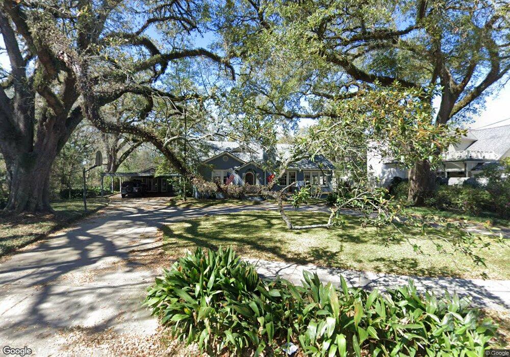
567 Lsu Ave Baton Rouge, LA 70808
Highlands/Perkins NeighborhoodEstimated Value: $764,455 - $954,000
5
Beds
4
Baths
3,445
Sq Ft
$250/Sq Ft
Est. Value
About This Home
This home is located at 567 Lsu Ave, Baton Rouge, LA 70808 and is currently estimated at $860,864, approximately $249 per square foot. 567 Lsu Ave is a home located in East Baton Rouge Parish with nearby schools including University Terrace Elementary School, Glasgow Middle School, and Mckinley Senior High School.
Ownership History
Date
Name
Owned For
Owner Type
Purchase Details
Closed on
May 1, 2001
Sold by
Nalewajek Hamilton Hamilton John Maxwell
Bought by
Richard Ronald G and Richard Dolores B
Current Estimated Value
Home Financials for this Owner
Home Financials are based on the most recent Mortgage that was taken out on this home.
Original Mortgage
$319,920
Outstanding Balance
$118,219
Interest Rate
6.89%
Estimated Equity
$742,645
Create a Home Valuation Report for This Property
The Home Valuation Report is an in-depth analysis detailing your home's value as well as a comparison with similar homes in the area
Home Values in the Area
Average Home Value in this Area
Purchase History
| Date | Buyer | Sale Price | Title Company |
|---|---|---|---|
| Richard Ronald G | $399,900 | -- |
Source: Public Records
Mortgage History
| Date | Status | Borrower | Loan Amount |
|---|---|---|---|
| Open | Richard Ronald G | $319,920 |
Source: Public Records
Tax History Compared to Growth
Tax History
| Year | Tax Paid | Tax Assessment Tax Assessment Total Assessment is a certain percentage of the fair market value that is determined by local assessors to be the total taxable value of land and additions on the property. | Land | Improvement |
|---|---|---|---|---|
| 2024 | $5,946 | $57,500 | $10,000 | $47,500 |
| 2023 | $5,946 | $51,000 | $10,000 | $41,000 |
| 2022 | $6,090 | $51,000 | $10,000 | $41,000 |
| 2021 | $5,950 | $51,000 | $10,000 | $41,000 |
| 2020 | $5,911 | $51,000 | $10,000 | $41,000 |
| 2019 | $5,995 | $49,500 | $10,000 | $39,500 |
| 2018 | $5,921 | $49,500 | $10,000 | $39,500 |
| 2017 | $5,921 | $49,500 | $10,000 | $39,500 |
| 2016 | $4,996 | $49,500 | $10,000 | $39,500 |
| 2015 | $4,476 | $45,000 | $10,000 | $35,000 |
| 2014 | $4,460 | $45,000 | $10,000 | $35,000 |
| 2013 | -- | $45,000 | $10,000 | $35,000 |
Source: Public Records
Map
Nearby Homes
- 505 Lsu Ave
- 452 Cornell Ave
- 405 Delgado Dr
- 335 Cornell Ave
- 424 Centenary Dr
- 544 Polytech Dr
- 225 Amherst Ave
- 4411 Highland Rd
- 990 Stanford Ave Unit 504
- 990 Stanford Ave Unit 415
- 990 Stanford Ave Unit 316
- 990 Stanford Ave Unit 307
- 990 Stanford Ave Unit 207
- 990 Stanford Ave Unit 207
- 921 Carriage Way
- 998 Stanford Ave Unit 311
- 998 Stanford Ave Unit 206
- 998 Stanford Ave Unit 303
- 998 Stanford Ave Unit 402
- 998 Stanford Ave Unit 211
- 567 L S U Ave
- 4444 W Lakeshore Dr
- 537 L S U Ave
- 4426 W Lakeshore Dr
- 537 Lsu Ave
- 578 L S U Ave
- 552 Cornell Ave
- 625 L S U Ave
- 578 Lsu Ave
- 625 Lsu Ave
- 550 L S U Ave
- 538 Cornell Ave
- 536 Lsu Ave
- 4408 W Lakeshore Dr
- 4408 W Lakeshore Dr
- 536 L S U Ave
- 635 L S U Ave
- 528 Cornell Ave
- 522 Lsu Ave
- 627 Stanford Ave