Estimated Value: $367,000 - $449,000
3
Beds
3
Baths
2,328
Sq Ft
$168/Sq Ft
Est. Value
About This Home
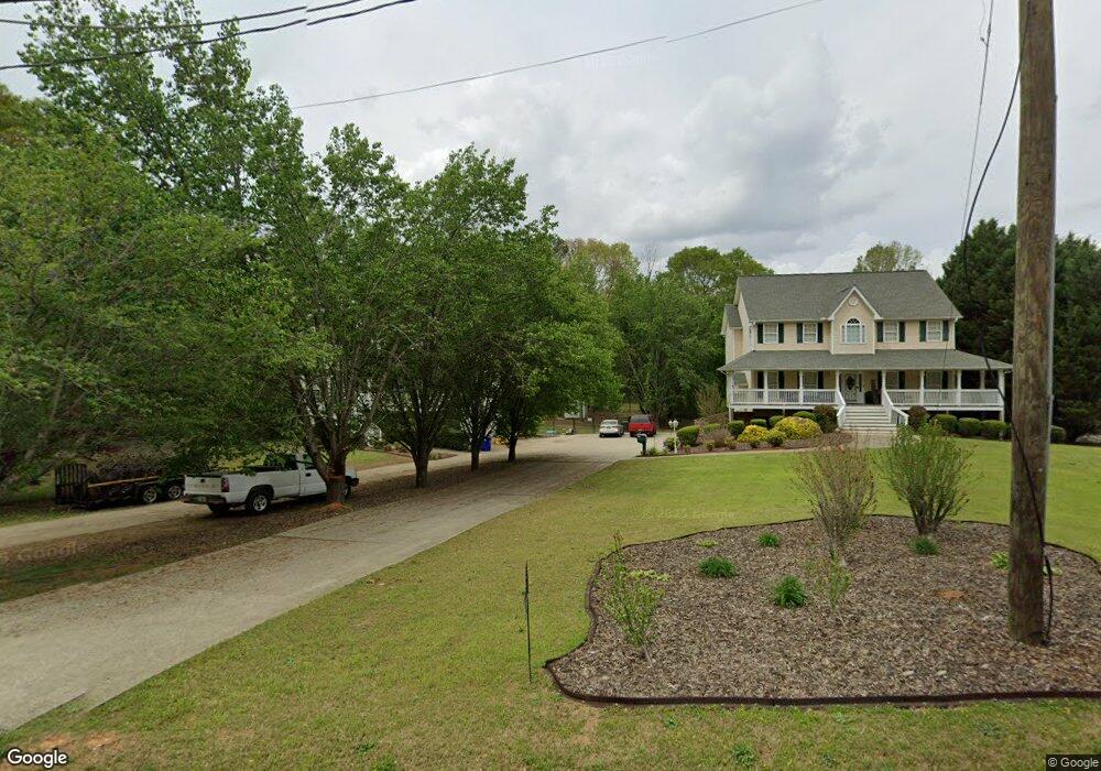
This home is located at 567 Morningside Dr, Hiram, GA 30141 and is currently estimated at $390,719, approximately $167 per square foot. 567 Morningside Dr is a home located in Paulding County with nearby schools including Bessie L. Baggett Elementary School, J. A. Dobbins Middle School, and Hiram High School.
Ownership History
Date
Name
Owned For
Owner Type
Purchase Details
Closed on
Dec 16, 2024
Sold by
Daniels Joanna
Bought by
Daniels Bridget
Current Estimated Value
Purchase Details
Closed on
Feb 26, 2002
Sold by
Daniels Joanna
Purchase Details
Closed on
Jun 29, 2001
Sold by
Johnson Glenn W
Create a Home Valuation Report for This Property
The Home Valuation Report is an in-depth analysis detailing your home's value as well as a comparison with similar homes in the area
Home Values in the Area
Average Home Value in this Area
Purchase History
| Date | Buyer | Sale Price | Title Company |
|---|---|---|---|
| Daniels Bridget | -- | -- | |
| -- | -- | -- | |
| -- | $32,600 | -- |
Source: Public Records
Tax History
| Year | Tax Paid | Tax Assessment Tax Assessment Total Assessment is a certain percentage of the fair market value that is determined by local assessors to be the total taxable value of land and additions on the property. | Land | Improvement |
|---|---|---|---|---|
| 2025 | $4,020 | $161,600 | $14,600 | $147,000 |
| 2024 | $3,895 | $159,840 | $14,600 | $145,240 |
| 2023 | $3,877 | $151,240 | $14,240 | $137,000 |
| 2022 | $3,513 | $136,640 | $11,600 | $125,040 |
| 2021 | $2,966 | $103,920 | $9,200 | $94,720 |
| 2020 | $2,750 | $94,440 | $8,680 | $85,760 |
| 2019 | $2,476 | $84,040 | $9,200 | $74,840 |
| 2018 | $2,492 | $84,560 | $9,080 | $75,480 |
| 2017 | $2,254 | $75,640 | $8,680 | $66,960 |
| 2016 | $1,904 | $64,840 | $8,680 | $56,160 |
| 2015 | $1,820 | $61,000 | $8,520 | $52,480 |
| 2014 | $1,676 | $54,960 | $7,840 | $47,120 |
| 2013 | -- | $50,360 | $8,600 | $41,760 |
Source: Public Records
Map
Nearby Homes
- 55 Cathy Ln
- 487 Valerie Cir
- 108 Vickie Dr
- 288 Valerie Cir
- 89 Kristie Cir
- 592 Linda Ln
- 589 Linda Ln
- 2690 Hiram Douglasville Hwy
- 332 Forkwood Way
- 401 Pine Valley Rd
- 37 Forkwood Cir
- 0 Morris Rd Unit 7337374
- 0 Morris Rd Unit 10626403
- 609 Pool Rd
- 725 Laird Rd
- 480 Pool Rd
- 38 Harpers Lake Dr
- 178 Laird Rd
- 371 Angham Rd
- 00 Bill Carruth Pkwy
- 599 Morningside Dr
- 561 Morningside Dr
- 539 Morningside Dr
- 499 Morningside Dr
- 605 Morningside Dr
- 596 Morningside Dr
- 606 Morningside Dr
- 630 Morningside Dr
- 3451 Morningside Dr
- 517 Morningside Dr
- 524 Morningside Dr
- 671 Morningside Dr
- 497 Morningside Dr
- 178 Somersby Ln
- 504 Morningside Dr
- 658 Morningside Dr
- 186 Somersby Ln
- 568 Morningside Dr
- 489 Morningside Dr
- 156 Somersby Ln
Your Personal Tour Guide
Ask me questions while you tour the home.