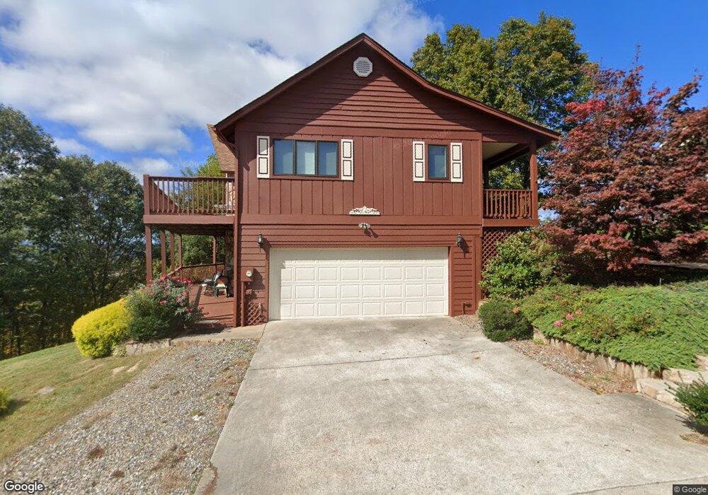
567 Mountain Top Rd Blairsville, GA 30512
Estimated Value: $411,124 - $538,000
3
Beds
3
Baths
1,706
Sq Ft
$282/Sq Ft
Est. Value
About This Home
This home is located at 567 Mountain Top Rd, Blairsville, GA 30512 and is currently estimated at $481,281, approximately $282 per square foot. 567 Mountain Top Rd is a home located in Union County with nearby schools including Union County Primary School, Union County Elementary School, and Union County Middle School.
Ownership History
Date
Name
Owned For
Owner Type
Purchase Details
Closed on
Dec 21, 2022
Sold by
Deyo Alice R
Bought by
Sapp Leigh and C/O Deyo Alice R
Current Estimated Value
Purchase Details
Closed on
Apr 27, 2007
Sold by
Mackey Michelle
Bought by
Williams Margy H
Purchase Details
Closed on
Jul 10, 2006
Sold by
Graesh Walter R
Bought by
Deyo Alice R
Purchase Details
Closed on
Jun 14, 1999
Sold by
Deyo Alice R
Bought by
Deyo Alice R and Deyo Walte
Purchase Details
Closed on
Nov 19, 1997
Sold by
Mountain Views Inc
Bought by
Deyo Alice R
Purchase Details
Closed on
Feb 16, 1994
Bought by
Mountain Views Inc
Create a Home Valuation Report for This Property
The Home Valuation Report is an in-depth analysis detailing your home's value as well as a comparison with similar homes in the area
Home Values in the Area
Average Home Value in this Area
Purchase History
| Date | Buyer | Sale Price | Title Company |
|---|---|---|---|
| Sapp Leigh | -- | -- | |
| Williams Margy H | $38,000 | -- | |
| Deyo Alice R | $125,000 | -- | |
| Deyo Alice R | -- | -- | |
| Deyo Alice R | $24,500 | -- | |
| Mountain Views Inc | -- | -- |
Source: Public Records
Tax History Compared to Growth
Tax History
| Year | Tax Paid | Tax Assessment Tax Assessment Total Assessment is a certain percentage of the fair market value that is determined by local assessors to be the total taxable value of land and additions on the property. | Land | Improvement |
|---|---|---|---|---|
| 2024 | $1,995 | $176,740 | $11,200 | $165,540 |
| 2023 | $2,198 | $172,820 | $11,200 | $161,620 |
| 2022 | $1,726 | $137,340 | $9,440 | $127,900 |
| 2021 | $1,629 | $111,100 | $6,240 | $104,860 |
| 2020 | $1,795 | $102,603 | $17,000 | $85,603 |
| 2019 | $1,693 | $102,603 | $17,000 | $85,603 |
| 2018 | $1,802 | $102,603 | $17,000 | $85,603 |
| 2017 | $1,661 | $102,603 | $17,000 | $85,603 |
| 2016 | $1,662 | $102,603 | $17,000 | $85,603 |
| 2015 | $1,672 | $102,603 | $17,000 | $85,603 |
| 2013 | -- | $102,602 | $17,000 | $85,602 |
Source: Public Records
Map
Nearby Homes
- Lot 47 Mountain Top Rd
- LOT37 Mountain Valley Ln
- LOT 54 Sunny View Dr
- 34 Mountain Valley Ln
- 102 Summit Way
- 517 Mountain Top Rd
- L 10&16 Josie Dr
- LOT 112 Natalie Ln
- 43 Little Beasley
- 171 Mountain Top Rd
- 54 Four Seasons Landing
- 399 Pinebrook Dr
- Lot 35 Middle Creek Rd
- Lot 149 Summit Way
- 1063 Summit Way
- na Aj's Holler
- n/a Wildwood Ln
- NA Nelson Cir
- 78 Reed White Dr
- 288 Kimsey St
- 591 Mountain Top Rd
- 562 Mountain Top Rd
- 540 Mountain Top Rd
- 578 Mountain Top Rd
- 0 The Mountain Unit 127 8425422
- 0 The Mountain Unit LOT 76 8864878
- 0 The Mountain Unit LOT 71 8830782
- 0 Mountian Top Ridge Unit 13E 3141327
- 3875 Mountain Top View Rd
- 618 Mountain Top Rd
- 88,85 East View
- 84 East View
- Lot 85 East View
- LOT 6 Moon View
- #15 Many Forks View
- LT 2 Mountain Top View Rd
- E East View Unit 64
- 1435 Beasley Trail
- 288 Sunny View Dr
- 618 Mountain Top