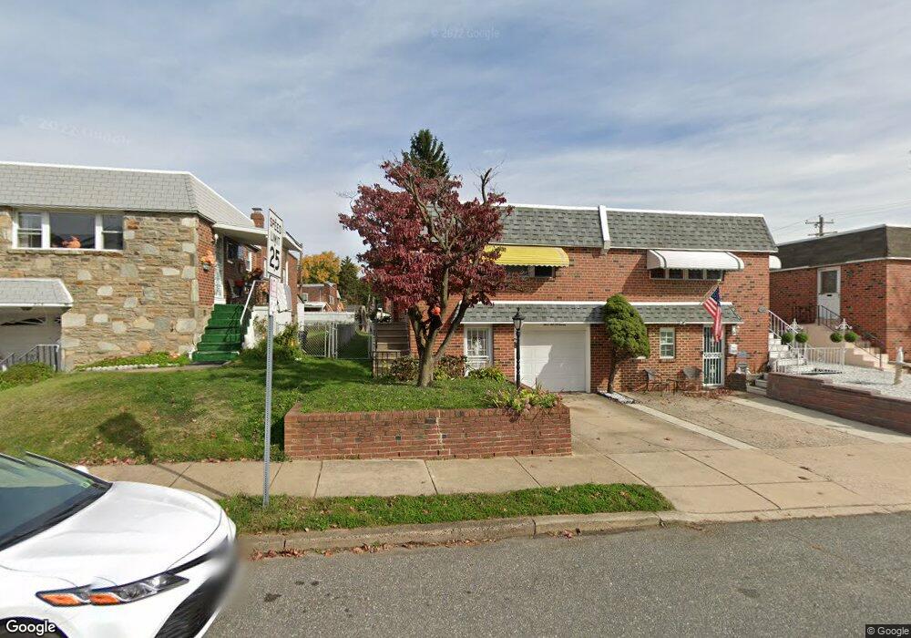
567 Selma St Philadelphia, PA 19116
Somerton NeighborhoodEstimated Value: $298,912 - $387,000
--
Bed
--
Bath
1,100
Sq Ft
$316/Sq Ft
Est. Value
About This Home
This home is located at 567 Selma St, Philadelphia, PA 19116 and is currently estimated at $347,978, approximately $316 per square foot. 567 Selma St is a home located in Philadelphia County with nearby schools including Loesche William H School, CCA Baldi Middle School, and George Washington High School.
Ownership History
Date
Name
Owned For
Owner Type
Purchase Details
Closed on
Oct 1, 2010
Sold by
Rippman Michele L and Lanzilotti Carmel A
Bought by
Lanzilotti Carmel A and Skiffington Carmel A
Current Estimated Value
Purchase Details
Closed on
Nov 20, 1998
Sold by
Lanzilotti Michael V
Bought by
Rippman Michele L and Skiffington Carmel A
Purchase Details
Closed on
Oct 10, 1997
Sold by
Lanzilotti Michael V and Lanzilotti Carmel R
Bought by
Lanzilotti Michael V
Create a Home Valuation Report for This Property
The Home Valuation Report is an in-depth analysis detailing your home's value as well as a comparison with similar homes in the area
Home Values in the Area
Average Home Value in this Area
Purchase History
| Date | Buyer | Sale Price | Title Company |
|---|---|---|---|
| Lanzilotti Carmel A | -- | None Available | |
| Rippman Michele L | -- | -- | |
| Lanzilotti Michael V | -- | -- |
Source: Public Records
Tax History Compared to Growth
Tax History
| Year | Tax Paid | Tax Assessment Tax Assessment Total Assessment is a certain percentage of the fair market value that is determined by local assessors to be the total taxable value of land and additions on the property. | Land | Improvement |
|---|---|---|---|---|
| 2026 | $3,455 | $299,600 | $59,920 | $239,680 |
| 2025 | $3,455 | $299,600 | $59,920 | $239,680 |
| 2024 | $3,455 | $299,600 | $59,920 | $239,680 |
| 2023 | $3,455 | $246,800 | $49,360 | $197,440 |
| 2022 | $2,326 | $201,800 | $49,360 | $152,440 |
| 2021 | $2,956 | $0 | $0 | $0 |
| 2020 | $2,956 | $0 | $0 | $0 |
| 2019 | $2,784 | $0 | $0 | $0 |
| 2018 | $2,227 | $0 | $0 | $0 |
| 2017 | $2,647 | $0 | $0 | $0 |
| 2016 | $2,206 | $0 | $0 | $0 |
| 2015 | $2,111 | $0 | $0 | $0 |
| 2014 | -- | $189,100 | $43,967 | $145,133 |
| 2012 | -- | $25,952 | $3,682 | $22,270 |
Source: Public Records
Map
Nearby Homes
- 807 Larkspur St
- 818 Burgess St
- 813 Piermont St
- 509 Larkspur St
- 825 Delray St
- 808 Densmore Rd
- 441 Tomlinson Rd Unit F6
- 11022 Ferndale St
- 11243 Jeanes Place
- 11715 Jeanes St
- 11012 Audubon Ave
- 10752 Jeanes St
- 11902 Barlow St
- 1104 Welton St
- 375 Avon St
- 11003 Stevens Rd
- 370 Selma St
- 10236 Selmer Terrace
- 10236 Jeanes St
- 11722 Audubon Ave