Estimated Value: $320,000 - $365,000
3
Beds
2
Baths
2,028
Sq Ft
$169/Sq Ft
Est. Value
About This Home
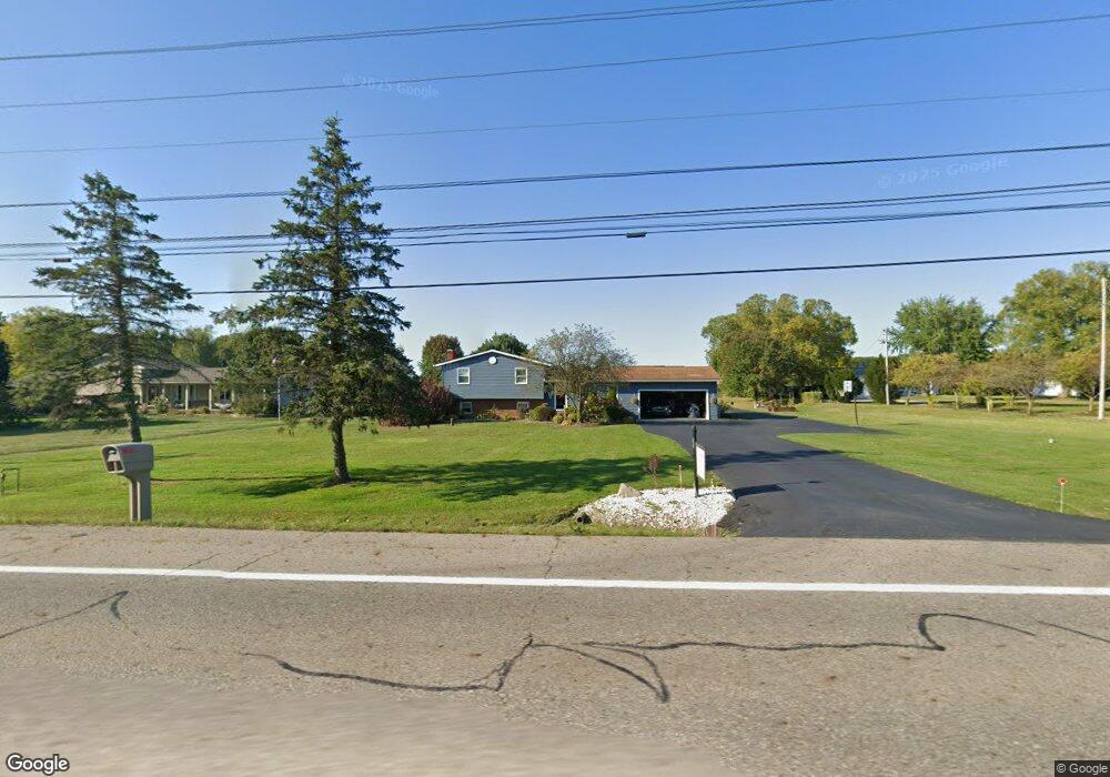
This home is located at 5675 State Route 82, Hiram, OH 44234 and is currently estimated at $342,971, approximately $169 per square foot. 5675 State Route 82 is a home located in Portage County with nearby schools including Crestwood Primary School, Crestwood Intermediate School, and Crestwood Middle School.
Ownership History
Date
Name
Owned For
Owner Type
Purchase Details
Closed on
Jan 10, 2009
Sold by
Viggiani Michael C and Viggiani Jennifer R
Bought by
Viggiani Michael C and Viggiani Jennifer R
Current Estimated Value
Home Financials for this Owner
Home Financials are based on the most recent Mortgage that was taken out on this home.
Original Mortgage
$208,333
Interest Rate
5.53%
Mortgage Type
FHA
Create a Home Valuation Report for This Property
The Home Valuation Report is an in-depth analysis detailing your home's value as well as a comparison with similar homes in the area
Home Values in the Area
Average Home Value in this Area
Purchase History
| Date | Buyer | Sale Price | Title Company |
|---|---|---|---|
| Viggiani Michael C | -- | Attorney |
Source: Public Records
Mortgage History
| Date | Status | Borrower | Loan Amount |
|---|---|---|---|
| Previous Owner | Viggiani Michael C | $208,333 |
Source: Public Records
Tax History Compared to Growth
Tax History
| Year | Tax Paid | Tax Assessment Tax Assessment Total Assessment is a certain percentage of the fair market value that is determined by local assessors to be the total taxable value of land and additions on the property. | Land | Improvement |
|---|---|---|---|---|
| 2024 | $4,062 | $103,570 | $13,650 | $89,920 |
| 2023 | $3,181 | $72,870 | $10,920 | $61,950 |
| 2022 | $3,211 | $72,870 | $10,920 | $61,950 |
| 2021 | $3,299 | $72,870 | $10,920 | $61,950 |
| 2020 | $2,946 | $62,130 | $10,920 | $51,210 |
| 2019 | $2,914 | $62,130 | $10,920 | $51,210 |
| 2018 | $2,894 | $57,300 | $10,920 | $46,380 |
| 2017 | $2,749 | $57,300 | $10,920 | $46,380 |
| 2016 | $2,741 | $57,300 | $10,920 | $46,380 |
| 2015 | $2,783 | $57,300 | $10,920 | $46,380 |
| 2014 | $2,800 | $57,300 | $10,920 | $46,380 |
| 2013 | $2,700 | $57,300 | $10,920 | $46,380 |
Source: Public Records
Map
Nearby Homes
- 4791 Pioneer Trail
- 10685 Limeridge Rd
- SR 82 Ohio 82
- 4620 Pioneer Trail
- 11131 State Route 44
- 0 Ambler Ln Unit 5142203
- 6846 Wakefield Rd
- 0 Garfield Rd
- 11470 Bowen Rd
- 7000 Village Way Dr
- 4364 Pioneer Trail
- 7050 Village Way Dr
- 7076 Village Way Dr
- 11383 Rolling Meadows Dr
- 19109 Tilden Rd
- 12167 Mantua Center Rd
- 6994 Hankee Rd
- 0 Infirmary Rd
- 18400 Shaw Rd
- Lot 7 Wheeler Rd
- 5649 State Route 82
- 5689 State Route 82
- 5645 State Route 82
- 5644 State Route 82
- 5719 State Route 82
- 5650 State Route 82
- 5766 State Route 82
- 5630 State Route 82
- 5619 State Route 82
- 5614 State Route 82
- 5601 State Route 82
- 5600 State Route 82
- 5757 State Route 82
- 5587 State Route 82
- 5782 State Route 82
- 5584 State Route 82
- 5570 State Route 82
- 5791 State Route 82
- 5567 Ohio 82
- 11676 Vaughn Rd