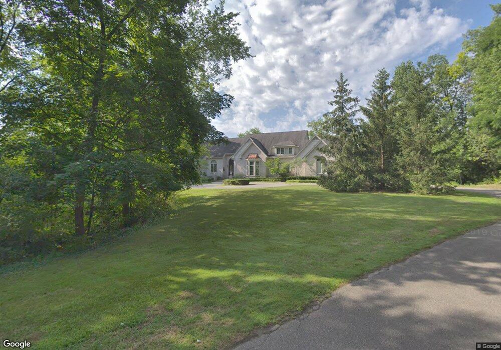
5683 Paulos Ln West Bloomfield, MI 48322
Estimated Value: $890,000 - $2,296,000
7
Beds
8
Baths
4,971
Sq Ft
$291/Sq Ft
Est. Value
About This Home
This home is located at 5683 Paulos Ln, West Bloomfield, MI 48322 and is currently estimated at $1,446,234, approximately $290 per square foot. 5683 Paulos Ln is a home located in Oakland County with nearby schools including Sheiko Elementary School, West Bloomfield Middle School, and Brookfield Academy - West Bloomfield Campus.
Ownership History
Date
Name
Owned For
Owner Type
Purchase Details
Closed on
Feb 5, 1998
Sold by
Markoul John
Bought by
Markoul John
Current Estimated Value
Purchase Details
Closed on
Apr 17, 1997
Sold by
Heppard Georgia
Bought by
Georgia Heppard Tr
Purchase Details
Closed on
Mar 25, 1996
Sold by
Markoul John
Bought by
Markoul John
Purchase Details
Closed on
Sep 5, 1995
Sold by
Markoul John
Bought by
Markoul John
Create a Home Valuation Report for This Property
The Home Valuation Report is an in-depth analysis detailing your home's value as well as a comparison with similar homes in the area
Home Values in the Area
Average Home Value in this Area
Purchase History
| Date | Buyer | Sale Price | Title Company |
|---|---|---|---|
| Markoul John | -- | -- | |
| Georgia Heppard Tr | -- | -- | |
| Markoul John | -- | -- | |
| Markoul John | -- | -- |
Source: Public Records
Tax History Compared to Growth
Tax History
| Year | Tax Paid | Tax Assessment Tax Assessment Total Assessment is a certain percentage of the fair market value that is determined by local assessors to be the total taxable value of land and additions on the property. | Land | Improvement |
|---|---|---|---|---|
| 2024 | $10,166 | $623,470 | $0 | $0 |
| 2022 | $9,557 | $608,390 | $175,740 | $432,650 |
| 2021 | $15,074 | $605,620 | $0 | $0 |
| 2020 | $9,245 | $605,910 | $125,830 | $480,080 |
| 2018 | $13,988 | $488,330 | $127,100 | $361,230 |
| 2015 | -- | $481,660 | $0 | $0 |
| 2014 | -- | $440,710 | $0 | $0 |
| 2011 | -- | $400,000 | $0 | $0 |
Source: Public Records
Map
Nearby Homes
- 3104 Spring St
- 5622 Powder Horn Dr
- 3035 Parkland Dr
- 5415 Fairway Ln
- 5321 Fairway Ln Unit 7
- 5780 Swan Lake Ct
- 5815 Bloomfield Glens Rd
- 3865 Stonecrest Rd
- 5881 Naneva Ct
- 0000 Putnam Dr
- 3930 Harris Ln
- 6151 Orchard Lake Rd Unit 103
- 6109 Orchard Lake Rd Unit 101
- 6145 Orchard Lake Rd Unit 204
- 6545 Post Oak Dr
- 4710 Cove Rd
- 6564 Alderley Way
- 4941 Fairway Ridge Cir
- 4670 Cove Rd
- 5352 W Doherty Dr
- 5678 Paulos Ln
- 3150 Parkland Dr
- 3135 Spring St
- 3135 Spring St Unit 1
- 3047 Spring St
- 3140 Parkland Dr
- 5656 Paulos Ln
- 5655 Paulos Ln
- 3130 Parkland Dr
- 3025 Spring St
- 3160 Parkland Dr
- 5720 Middlebelt Rd
- 5710 Middlebelt Rd
- 3120 Parkland Dr
- 5650 Willow Valley Dr Unit Bldg-Unit
- 5650 Willow Valley Dr
- 5800 Middlebelt Rd
- 3015 Spring St
- 3143 Parkland Dr
- 3050 Spring St