Estimated Value: $400,857 - $440,000
4
Beds
3
Baths
2,161
Sq Ft
$193/Sq Ft
Est. Value
About This Home
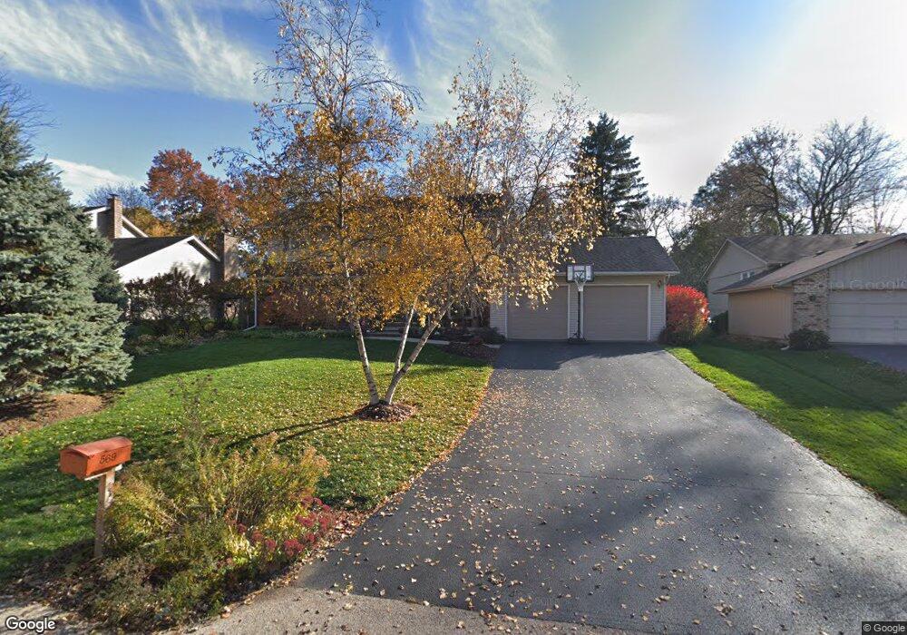
This home is located at 569 Ada St, Cary, IL 60013 and is currently estimated at $417,464, approximately $193 per square foot. 569 Ada St is a home located in McHenry County with nearby schools including Briargate Elementary School, Cary Jr High School, and Cary Grove High School.
Ownership History
Date
Name
Owned For
Owner Type
Purchase Details
Closed on
Nov 22, 2005
Sold by
Miller Gary and Miller Marilyn
Bought by
Calamari Steven A and Calamari Dawn M
Current Estimated Value
Home Financials for this Owner
Home Financials are based on the most recent Mortgage that was taken out on this home.
Original Mortgage
$252,000
Interest Rate
5.62%
Mortgage Type
Unknown
Purchase Details
Closed on
Sep 30, 1993
Sold by
Glenn William R and Glenn Carole L
Bought by
Miller Gary and Miller Marilyn
Home Financials for this Owner
Home Financials are based on the most recent Mortgage that was taken out on this home.
Original Mortgage
$156,500
Interest Rate
7.15%
Create a Home Valuation Report for This Property
The Home Valuation Report is an in-depth analysis detailing your home's value as well as a comparison with similar homes in the area
Home Values in the Area
Average Home Value in this Area
Purchase History
| Date | Buyer | Sale Price | Title Company |
|---|---|---|---|
| Calamari Steven A | $315,000 | Republic Title Company | |
| Miller Gary | $174,500 | Universal Title Services Inc |
Source: Public Records
Mortgage History
| Date | Status | Borrower | Loan Amount |
|---|---|---|---|
| Previous Owner | Calamari Steven A | $252,000 | |
| Previous Owner | Miller Gary | $156,500 |
Source: Public Records
Tax History Compared to Growth
Tax History
| Year | Tax Paid | Tax Assessment Tax Assessment Total Assessment is a certain percentage of the fair market value that is determined by local assessors to be the total taxable value of land and additions on the property. | Land | Improvement |
|---|---|---|---|---|
| 2024 | $9,480 | $128,573 | $21,190 | $107,383 |
| 2023 | $9,904 | $114,993 | $18,952 | $96,041 |
| 2022 | $9,113 | $103,327 | $26,086 | $77,241 |
| 2021 | $8,685 | $96,261 | $24,302 | $71,959 |
| 2020 | $8,427 | $92,854 | $23,442 | $69,412 |
| 2019 | $8,261 | $88,873 | $22,437 | $66,436 |
| 2018 | $7,786 | $82,100 | $20,727 | $61,373 |
| 2017 | $7,635 | $77,343 | $19,526 | $57,817 |
| 2016 | $7,576 | $72,541 | $18,314 | $54,227 |
| 2013 | -- | $66,808 | $17,085 | $49,723 |
Source: Public Records
Map
Nearby Homes
- 226 Aberdeen Rd
- 641 Alida Dr
- 60 S Seebert St
- 589 Arthur Dr
- 204 Country Commons Rd
- 2 Daybreak Ridge Trail
- 550 Norman Dr
- Lots 2,3,4 Northwest Hwy
- 411 Park Ave
- 341 Cold Spring St
- 331 Cold Spring St
- 321 Cold Spring St
- 413 Haber Rd Unit 5
- 417 Haber Rd Unit 6
- 421 Haber Rd Unit 7
- 745 Harper Ave
- 780 Merrimac St
- 324 Alma Terrace
- 800 Big Bear Trail
- 26 Wagner Dr