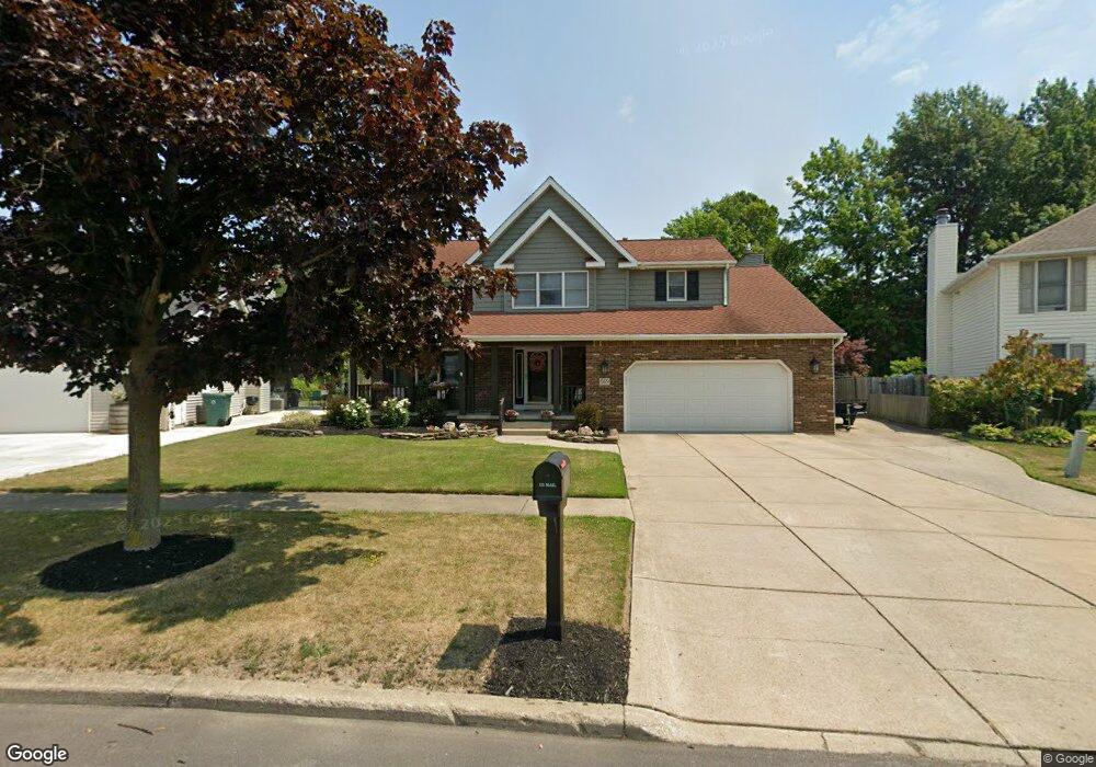
569 Homestead Dr North Tonawanda, NY 14120
Estimated Value: $469,000 - $601,000
4
Beds
3
Baths
2,629
Sq Ft
$196/Sq Ft
Est. Value
About This Home
This home is located at 569 Homestead Dr, North Tonawanda, NY 14120 and is currently estimated at $516,110, approximately $196 per square foot. 569 Homestead Dr is a home located in Niagara County with nearby schools including Edward Town Middle School, Niagara-Wheatfield Senior High School, and St. John Lutheran School.
Ownership History
Date
Name
Owned For
Owner Type
Purchase Details
Closed on
Jul 26, 2017
Sold by
Camarre James P and Camarre Michele A
Bought by
Woodroe James J and Woodroe Dori
Current Estimated Value
Home Financials for this Owner
Home Financials are based on the most recent Mortgage that was taken out on this home.
Original Mortgage
$125,720
Outstanding Balance
$104,676
Interest Rate
3.88%
Mortgage Type
New Conventional
Estimated Equity
$411,434
Create a Home Valuation Report for This Property
The Home Valuation Report is an in-depth analysis detailing your home's value as well as a comparison with similar homes in the area
Home Values in the Area
Average Home Value in this Area
Purchase History
| Date | Buyer | Sale Price | Title Company |
|---|---|---|---|
| Woodroe James J | $255,900 | None Available |
Source: Public Records
Mortgage History
| Date | Status | Borrower | Loan Amount |
|---|---|---|---|
| Open | Woodroe James J | $125,720 |
Source: Public Records
Tax History Compared to Growth
Tax History
| Year | Tax Paid | Tax Assessment Tax Assessment Total Assessment is a certain percentage of the fair market value that is determined by local assessors to be the total taxable value of land and additions on the property. | Land | Improvement |
|---|---|---|---|---|
| 2024 | $7,281 | $206,200 | $56,600 | $149,600 |
| 2023 | $7,099 | $206,200 | $56,600 | $149,600 |
| 2022 | $6,829 | $206,200 | $56,600 | $149,600 |
| 2021 | $6,829 | $206,200 | $56,600 | $149,600 |
| 2020 | $6,829 | $206,200 | $56,600 | $149,600 |
| 2019 | $2,825 | $206,200 | $56,600 | $149,600 |
| 2018 | $6,804 | $206,200 | $56,600 | $149,600 |
| 2017 | $5,427 | $184,900 | $56,600 | $128,300 |
| 2016 | $5,297 | $184,900 | $56,600 | $128,300 |
| 2015 | -- | $184,900 | $56,600 | $128,300 |
| 2014 | -- | $184,900 | $56,600 | $128,300 |
Source: Public Records
Map
Nearby Homes
- 2828 Homeyer Rd
- 7196 Ward Rd
- 376 Roger Ave
- 729 Ruie Rd
- 399 Frontier Ave
- 298 Ward Rd
- 864 Ruie Rd
- 86 Community Dr
- 6989 Ward Rd
- 2576 Ferchen St
- 339 Daniel Dr
- 186 E Felton St
- 2974 Niagara Falls Blvd
- 77 Porter Ave
- 1091 Ruie Rd
- 88 E Felton St
- 1201 Payne Ave
- 7373 Balla Dr
- 257 Fredericka St
- 222 Fredericka St
- 575 Homestead Dr
- 561 Homestead Dr
- 579 Homestead Dr
- 553 Homestead Dr
- 562 Homestead Dr
- 547 Homestead Dr
- 587 Homestead Dr
- 552 Homestead Dr
- 544 Homestead Dr
- 539 Homestead Dr
- 533 Homestead Dr
- 538 Homestead Dr
- 525 Homestead Dr
- 519 Homestead Dr
- 522 Homestead Dr
- 279 Walter Dr
- 513 Homestead Dr
- 265 Walter Dr
- 510 Homestead Dr
- 505 Homestead Dr