

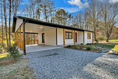


569 Number 20 Mine Rd Mc Caysville, GA 30555
Estimated payment $2,439/month
Total Views
4,319
3
Beds
2
Baths
1,904
Sq Ft
$236
Price per Sq Ft
Highlights
- Hot Property
- View of Trees or Woods
- Cathedral Ceiling
- Built in 1988 | Newly Remodeled
- Craftsman Architecture
- Main Floor Primary Bedroom
About This Home
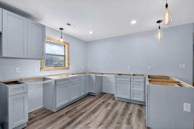
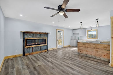
? Fully Renovated 3BR/2BA Ranch Minutes from Blue Ridge! Welcome home to this beautifully remodeled 3-bedroom, 2-bath ranch-style home, perfectly situated just 15 minutes from Blue Ridge and only minutes to McCaysville and the Toccoa/Ocoee River. Every detail has been thoughtfully updated to provide modern comfort, efficiency, and low-maintenance living. Step inside to discover luxury vinyl plank flooring throughout, new electrical and plumbing systems, and a brand-new HVAC system with a 10-year warranty. The open-concept kitchen features new countertops, modern appliances, and stylish finishes, ideal for both cooking and entertaining. Enjoy peace of mind and energy efficiency with spray foam insulation in the main living areas and closed-cell insulation in the basement. The bonus room offers flexible space—perfect for a game room, recreation area, or additional living space. Outside, the level yard provides endless possibilities for landscaping, outdoor living, or a garden retreat. This move-in-ready home combines modern upgrades with mountain charm in a prime location—close to Blue Ridge, McCaysville, and outdoor adventures on the Toccoa and Ocoee Rivers.
Listing Agent
Ansley Real Estate Christie's Int. Real Estate Brokerage Phone: 7066134663 License #295700 Listed on: 11/09/2025
Home Details
Home Type
- Single Family
Year Built
- Built in 1988 | Newly Remodeled
Lot Details
- 1.5 Acre Lot
- Property fronts a county road
- Garden
Parking
- 2 Car Garage
- Carport
- Driveway
- Open Parking
Property Views
- Woods
- Mountain
- Seasonal
Home Design
- Craftsman Architecture
- Contemporary Architecture
- Traditional Architecture
- Cottage
- Frame Construction
- Metal Roof
- Wood Siding
Interior Spaces
- 1,904 Sq Ft Home
- 2-Story Property
- Cathedral Ceiling
- 1 Fireplace
- Insulated Windows
- Aluminum Window Frames
- Carpet
Kitchen
- Range
- Microwave
- Dishwasher
Bedrooms and Bathrooms
- 3 Bedrooms
- Primary Bedroom on Main
- 2 Full Bathrooms
Finished Basement
- Basement Fills Entire Space Under The House
- Laundry in Basement
Utilities
- Central Heating and Cooling System
- Septic Tank
Community Details
- No Home Owners Association
Listing and Financial Details
- Assessor Parcel Number 0061075d2
Map
Create a Home Valuation Report for This Property
The Home Valuation Report is an in-depth analysis detailing your home's value as well as a comparison with similar homes in the area
Home Values in the Area
Average Home Value in this Area
Tax History
| Year | Tax Paid | Tax Assessment Tax Assessment Total Assessment is a certain percentage of the fair market value that is determined by local assessors to be the total taxable value of land and additions on the property. | Land | Improvement |
|---|---|---|---|---|
| 2025 | $961 | $99,833 | $47,559 | $52,274 |
| 2024 | $961 | $169,063 | $82,205 | $86,858 |
| 2023 | $907 | $153,462 | $82,205 | $71,257 |
| 2022 | $208 | $154,153 | $82,205 | $71,948 |
| 2021 | $135 | $125,834 | $82,205 | $43,629 |
| 2020 | $131 | $125,834 | $82,205 | $43,629 |
| 2019 | $130 | $125,834 | $82,205 | $43,629 |
| 2018 | $111 | $108,322 | $64,728 | $43,594 |
| 2016 | $85 | $99,559 | $64,728 | $34,831 |
| 2015 | $92 | $101,854 | $64,728 | $37,126 |
| 2014 | $73 | $108,457 | $70,294 | $38,163 |
| 2013 | -- | $98,327 | $70,294 | $28,033 |
Source: Public Records
Property History
| Date | Event | Price | List to Sale | Price per Sq Ft |
|---|---|---|---|---|
| 11/09/2025 11/09/25 | For Sale | $448,400 | -- | $236 / Sq Ft |
Source: Northeast Georgia Board of REALTORS®
Purchase History
| Date | Type | Sale Price | Title Company |
|---|---|---|---|
| Warranty Deed | -- | -- | |
| Warranty Deed | $120,000 | -- | |
| Warranty Deed | -- | -- | |
| Warranty Deed | -- | -- | |
| Deed | -- | -- | |
| Deed | -- | -- |
Source: Public Records
About the Listing Agent
Rachel Callihan-Cowart is a Georgia licensed REALTOR® with both personal and professional building experience as well as a licensed realtor in Oklahoma for over 7 years. She has received numerous achievement awards every year, even in a down market. Rachel established and grew a small business from scratch and was nominated for Fannin Business Woman of the year in 2004. Her specialty is people-pleasing, ensuring that her clients find exactly what they are looking for.
Rachel's Other Listings
-
$2,900,000
- 5 Beds
- 5.5 Baths
- 5,390 Sq Ft
- 101 Bennett Springs Ct
- Mineral Bluff, GA
Extraordinary one-of-a-kind Marc Nicholson custom luxury estate situated on 3.34 pristine mountain acres within an ultra-exclusive gated community featuring complete paved road access, magnificent community pavilion with outdoor kitchen, and private Toccoa River access just minutes from downtown Blue Ridge. This breathtaking 5-bedroom, 5.5-bathroom architectural masterpiece showcases stunning
Rachel Callihan Ansley RE|Christie's Int'l RE
-
$349,900
- Land
- 4.5 Acres
- $77,756 per Acre
- 0 Highway 2
- Unit 10591825
- Blue Ridge, GA
Over 600 feet of frontage on the beautiful Little Fightingtown Creek, this 4.5-acre park-like property offers a rare opportunity for your dream home, mini farm, or investment. Bring your horses!! The level terrain features a mix of mature hardwoods and fruit trees, ideal for gardening or enjoying the peaceful natural surroundings. With potential to subdivide, the land offers flexibility for
Rachel Callihan Ansley RE|Christie's Int'l RE
-
$2,400,000
- 3 Beds
- 2.5 Baths
- 3,856 Sq Ft
- 270 Stone Ln
- Blue Ridge, GA
Just minutes and only 3 miles to Downtown Blue Ridge, this stunning estate is nestled on 27 acres of rolling hills and offers the perfect blend of privacy and luxury. Bordering Mercier Orchards, the property features a serene creek, fenced 3-acre section with a gated entrance, and a massive 2-by-40 outdoor entertaining area complete with a pool and terrace-level media room. The beautifully
Rachel Callihan Ansley Real Estate| Christie's International Real Estate
Source: Northeast Georgia Board of REALTORS®
MLS Number: 420171
APN: 0061-075
Disclaimer: Certain information contained herein is derived from information provided by parties other than Homes.com. All information provided is deemed reliable, but is not guaranteed to be accurate and should be independently verified.
![]() IDX information is provided exclusively for personal, non-commercial use, and may not be used for any purpose other than to identify prospective properties consumers may be interested in purchasing. Information is deemed reliable but not guaranteed.
IDX information is provided exclusively for personal, non-commercial use, and may not be used for any purpose other than to identify prospective properties consumers may be interested in purchasing. Information is deemed reliable but not guaranteed.
Nearby Homes
- 643 Number 20 Mine Rd
- 170 Ashley Dr
- 4165 Mobile Rd Unit 4
- 4165 Mobile Rd
- 1843 Old Mobile Rd
- 4097 Mobile Rd
- 44 Woodlawn Dr
- 833 Blue Ridge Dr Hwy 5
- TRACT B Kyle Rd
- 1082 Sunset Rd
- 11 Ivy Overlook
- 1248 Sunset Rd
- 2417 Mobile Rd
- 117 Fightingtown Creek Rd
- 168 Fightingtown Creek Rd
- 38 Friendly Ln
- 267 Indian Trail
- 38 Sweetwater Trail
- 39 Pond Rd
- 1043 Sunset Rd
- 600 Indian Trail
- 610 Madola Rd Unit 1
- 610 Madola Rd
- 620 Stiles Rd Unit A
- 620 Stiles Rd
- 245 Blue Ridge Dr
- 113 Prospect St
- 24 Hamby Rd
- 150 Arrow Way Unit ID1333767P
- 98 Shalom Ln Unit ID1252436P
- 2680 River Rd
- 2905 River Rd
- 3890 Mineral Bluff Hwy
- 586 Sun Valley Dr
- 664 Fox Run Dr
- 443 Fox Run Dr Unit ID1018182P
- 181 Sugar Mountain Rd Unit ID1252489P
- 101 Hothouse Dr
- 88 Black Gum Ln
- 25 Walhala Trail Unit ID1231291P