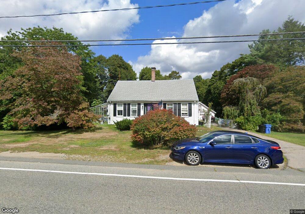
569 Plymouth St Whitman, MA 02382
Estimated Value: $533,874 - $587,000
3
Beds
1
Bath
1,576
Sq Ft
$353/Sq Ft
Est. Value
About This Home
This home is located at 569 Plymouth St, Whitman, MA 02382 and is currently estimated at $555,719, approximately $352 per square foot. 569 Plymouth St is a home located in Plymouth County with nearby schools including St Bridget School.
Ownership History
Date
Name
Owned For
Owner Type
Purchase Details
Closed on
May 24, 2004
Sold by
Hammond Robert C
Bought by
Rosemond Donald and Thompson Joell C
Current Estimated Value
Home Financials for this Owner
Home Financials are based on the most recent Mortgage that was taken out on this home.
Original Mortgage
$284,050
Outstanding Balance
$135,517
Interest Rate
5.75%
Mortgage Type
Purchase Money Mortgage
Estimated Equity
$420,202
Create a Home Valuation Report for This Property
The Home Valuation Report is an in-depth analysis detailing your home's value as well as a comparison with similar homes in the area
Home Values in the Area
Average Home Value in this Area
Purchase History
| Date | Buyer | Sale Price | Title Company |
|---|---|---|---|
| Rosemond Donald | $299,000 | -- |
Source: Public Records
Mortgage History
| Date | Status | Borrower | Loan Amount |
|---|---|---|---|
| Open | Rosemond Donald | $284,050 |
Source: Public Records
Tax History Compared to Growth
Tax History
| Year | Tax Paid | Tax Assessment Tax Assessment Total Assessment is a certain percentage of the fair market value that is determined by local assessors to be the total taxable value of land and additions on the property. | Land | Improvement |
|---|---|---|---|---|
| 2025 | $5,836 | $444,800 | $221,000 | $223,800 |
| 2024 | $5,544 | $435,200 | $216,400 | $218,800 |
| 2023 | $5,459 | $402,300 | $198,400 | $203,900 |
| 2022 | $5,378 | $369,400 | $180,400 | $189,000 |
| 2021 | $4,966 | $320,400 | $152,200 | $168,200 |
| 2020 | $4,771 | $301,000 | $138,700 | $162,300 |
| 2019 | $4,492 | $292,100 | $138,700 | $153,400 |
| 2018 | $4,190 | $261,700 | $132,000 | $129,700 |
| 2017 | $3,946 | $261,700 | $132,000 | $129,700 |
| 2016 | $3,742 | $240,000 | $120,700 | $119,300 |
| 2015 | $3,746 | $240,000 | $120,700 | $119,300 |
Source: Public Records
Map
Nearby Homes
- 679 Plymouth St
- 40 Lazel St
- 96 Cherry St Unit 98
- 23 Reed Place
- 177 Jean Carol Rd
- 137 Peregrine Rd
- 912 Plymouth St
- 60 Fairview St
- 896 Plymouth St
- 281 Commercial St
- 54-56 Stetson St
- 34 Dana St
- 55 Plymouth St Unit A5
- 48 Day St
- 214 Winter St
- 800 Plymouth St
- 131 Holly Ridge Dr
- 10 Birch Bottom Cir
- 89 Holly Ridge Dr
- 109 Fullerton Ave
- 555 Plymouth St
- 583 Plymouth St
- 587 Plymouth St
- 564 Plymouth St
- 558 Plymouth St
- 549 Plymouth St
- 5 Green Acres Dr
- 595 Plymouth St
- 586 Plymouth St
- 15 Green Acres Dr
- 590 Plymouth St
- 552 Plymouth St
- 537 Plymouth St
- 600 Plymouth St
- 23 Green Acres Dr
- 22 Kerri Ln
- 544 Plymouth St
- 611 Plymouth St
- 50 Holmes Terrace
- 33 Green Acres Dr