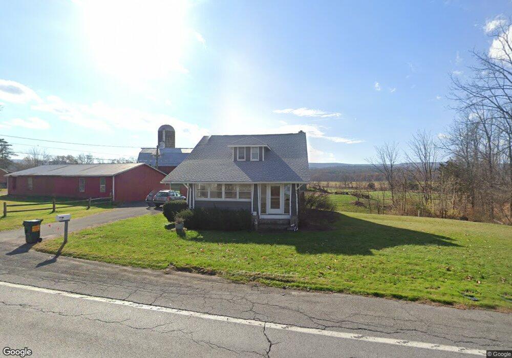
5691 Route 209 Kerhonkson, NY 12446
Rochester NeighborhoodEstimated Value: $323,000 - $526,000
3
Beds
1
Bath
1,400
Sq Ft
$291/Sq Ft
Est. Value
About This Home
This home is located at 5691 Route 209, Kerhonkson, NY 12446 and is currently estimated at $406,838, approximately $290 per square foot. 5691 Route 209 is a home located in Ulster County with nearby schools including Marbletown Elementary School and Rondout Valley High School.
Ownership History
Date
Name
Owned For
Owner Type
Purchase Details
Closed on
May 26, 2022
Sold by
5691 Rt 209 Llc
Bought by
Dolan Robert M
Current Estimated Value
Home Financials for this Owner
Home Financials are based on the most recent Mortgage that was taken out on this home.
Original Mortgage
$229,200
Outstanding Balance
$217,564
Interest Rate
5%
Mortgage Type
Purchase Money Mortgage
Estimated Equity
$189,274
Purchase Details
Closed on
Apr 3, 2019
Sold by
Stack Klay B and Stack Jane
Bought by
5691 Route 209 Llc
Purchase Details
Closed on
Sep 1, 2017
Sold by
Fhlmc
Bought by
Stack Klay B and Stack Jane
Create a Home Valuation Report for This Property
The Home Valuation Report is an in-depth analysis detailing your home's value as well as a comparison with similar homes in the area
Home Values in the Area
Average Home Value in this Area
Purchase History
| Date | Buyer | Sale Price | Title Company |
|---|---|---|---|
| Dolan Robert M | $287,000 | None Available | |
| 5691 Route 209 Llc | -- | -- | |
| Stack Klay B | $60,750 | -- |
Source: Public Records
Mortgage History
| Date | Status | Borrower | Loan Amount |
|---|---|---|---|
| Open | Dolan Robert M | $229,200 |
Source: Public Records
Tax History Compared to Growth
Tax History
| Year | Tax Paid | Tax Assessment Tax Assessment Total Assessment is a certain percentage of the fair market value that is determined by local assessors to be the total taxable value of land and additions on the property. | Land | Improvement |
|---|---|---|---|---|
| 2024 | $3,684 | $143,850 | $32,000 | $111,850 |
| 2023 | $3,652 | $143,850 | $32,000 | $111,850 |
| 2022 | $3,341 | $143,850 | $32,000 | $111,850 |
| 2021 | $3,341 | $143,850 | $32,000 | $111,850 |
| 2020 | $3,427 | $143,850 | $32,000 | $111,850 |
| 2019 | $4,133 | $137,000 | $32,000 | $105,000 |
| 2018 | $3,597 | $137,000 | $31,000 | $106,000 |
| 2017 | $7,288 | $160,200 | $30,500 | $129,700 |
| 2016 | $4,094 | $160,200 | $30,500 | $129,700 |
| 2015 | -- | $160,200 | $30,500 | $129,700 |
| 2014 | -- | $160,200 | $30,500 | $129,700 |
Source: Public Records
Map
Nearby Homes
- 9 Hamilton Dr
- 45 Millbrook Ln
- 17 Boice Mill Rd
- 19 Boice Mill Rd
- 15 Teradon
- 270 Mettacahonts Rd
- 222 Queens Hwy
- 83 Sages Loop
- 83 Sages Loop Rd
- 87 Boice Mill Rd
- 30 Aevo Rd
- 464 Mill Hook Rd
- 16 Roberts Dr
- 60 Terwilliger Rd
- 363 Mettacahonts Rd Unit 5
- 161 Boice Mill Rd
- 30 & 40 Fawn Ln
- TBD Route 209
- 1683 Berme Rd
- 44 Stony Rd
- 5691 Us Highway 209
- 5691 Route 209
- 5688 Route 209
- 5688 Route 209
- 5684 Route 209
- 5684 U S 209
- 5671 Route 209
- 5671 Route 209
- 5728 Route 209 Unit 5
- 5728 Route 209 Unit 3
- 5728 Route 209 Unit 1
- 5728 Route 209 Unit 4b
- 5728 Route 209 Unit 4a
- 5728 Route 209
- 5671 Us Highway 209
- 5671 U S 209
- 5728 U S 209 Unit 4b
- 5728 U S 209
- 5728 209 Unit C
- 5688 U S 209