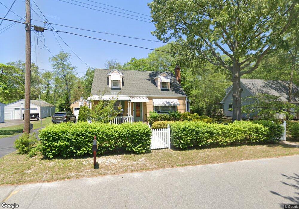
57 Atlantic Ave Waretown, NJ 08758
Estimated Value: $347,000 - $433,000
3
Beds
2
Baths
1,408
Sq Ft
$277/Sq Ft
Est. Value
About This Home
This home is located at 57 Atlantic Ave, Waretown, NJ 08758 and is currently estimated at $389,591, approximately $276 per square foot. 57 Atlantic Ave is a home located in Ocean County with nearby schools including Waretown Elementary School and Frederic A. Priff Elementary School.
Ownership History
Date
Name
Owned For
Owner Type
Purchase Details
Closed on
May 15, 2007
Sold by
Mcnickle Frederick S and Mcnickle Kerry L
Bought by
Thom Steven
Current Estimated Value
Home Financials for this Owner
Home Financials are based on the most recent Mortgage that was taken out on this home.
Original Mortgage
$125,000
Outstanding Balance
$76,117
Interest Rate
6.19%
Mortgage Type
Purchase Money Mortgage
Estimated Equity
$313,474
Purchase Details
Closed on
Oct 19, 1999
Sold by
Estate Of Alexander Haupt St and Haupt Alexander
Bought by
Mcnickle Frederick
Home Financials for this Owner
Home Financials are based on the most recent Mortgage that was taken out on this home.
Original Mortgage
$79,346
Interest Rate
7.78%
Mortgage Type
FHA
Create a Home Valuation Report for This Property
The Home Valuation Report is an in-depth analysis detailing your home's value as well as a comparison with similar homes in the area
Home Values in the Area
Average Home Value in this Area
Purchase History
| Date | Buyer | Sale Price | Title Company |
|---|---|---|---|
| Thom Steven | $245,000 | None Available | |
| Mcnickle Frederick | $80,000 | -- |
Source: Public Records
Mortgage History
| Date | Status | Borrower | Loan Amount |
|---|---|---|---|
| Open | Thom Steven | $125,000 | |
| Previous Owner | Mcnickle Frederick | $79,346 |
Source: Public Records
Tax History
| Year | Tax Paid | Tax Assessment Tax Assessment Total Assessment is a certain percentage of the fair market value that is determined by local assessors to be the total taxable value of land and additions on the property. | Land | Improvement |
|---|---|---|---|---|
| 2025 | $4,622 | $306,300 | $100,000 | $206,300 |
| 2024 | $4,181 | $306,300 | $100,000 | $206,300 |
Source: Public Records
Map
Nearby Homes
- 51 Oregon Ave
- 70 Main St
- 55 Main St
- 66 Clearwater Dr
- 56 Bryant Rd
- 101 Illinois Ave
- 33 Pennsylvania Ave
- 17 Pennsylvania Ave
- 35 Pennsylvania Ave
- 105 Atlantic Ave Unit 4
- 104 Clearwater Dr
- 46 Baybreeze Dr
- 76 Sheridan St
- 109 Ocean Ave
- 116 Dollmore Ave
- 14 Hawkins Way
- 16 Davey Jones Way
- 33 Forest Park Dr
- 29 Forest Park Dr
- 27 Forest Park Dr
- 59 Atlantic Ave
- 55 Atlantic Ave
- 58 Baltic Ave
- 56 Atlantic Ave
- 58 Atlantic Ave
- 61 Atlantic Ave
- 60 Baltic Ave
- 63 Atlantic Ave
- 60 Atlantic Ave
- 55 Clearwater Dr
- 57 Clearwater Dr
- 59 Clearwater Dr
- 53 Clearwater Dr
- 62 Atlantic Ave
- 62 Baltic Ave
- 65 Atlantic Ave
- 64 Atlantic Ave
- 58 Oregon Ave
- 61 Clearwater Dr
- 66 Main St
Your Personal Tour Guide
Ask me questions while you tour the home.