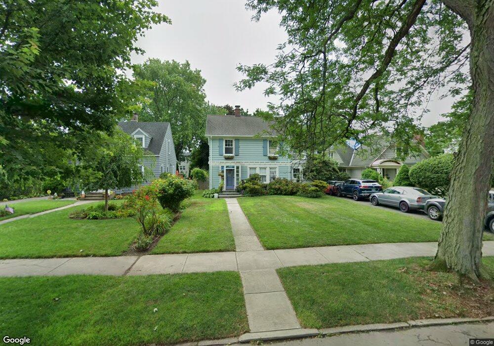
57 Bartram Ave Bridgeport, CT 06605
Black Rock NeighborhoodEstimated Value: $416,000 - $699,000
About This Home
This home is located at 57 Bartram Ave, Bridgeport, CT 06605 and is currently estimated at $544,032, approximately $304 per square foot. 57 Bartram Ave is a home located in Fairfield County with nearby schools including Black Rock School, Bassick High School, and Park City Prep Charter School.
Ownership History
We collect this data history from publicly available records. To have your information removed, we recommend requesting removal directly through your county’s website.
Purchase Details
Purchase Details
Purchase Details
Purchase Details
Home Values in the Area
Average Home Value in this Area
Purchase History
We collect this data history from publicly available records. To have your information removed, we recommend requesting removal directly through your county’s website.
| Date | Buyer | Sale Price | Title Company |
|---|---|---|---|
| $158,100 | -- | ||
| $158,100 | -- | ||
| $150,000 | -- | ||
| $190,000 | -- | ||
| $185,500 | -- |
Mortgage History
We collect this data history from publicly available records. To have your information removed, we recommend requesting removal directly through your county’s website.
| Date | Status | Borrower | Loan Amount |
|---|---|---|---|
| Open | $260,943 | ||
| Closed | $350,000 |
Tax History
We collect this data history from publicly available records. To have your information removed, we recommend requesting removal directly through your county’s website.
| Year | Tax Paid | Tax Assessment Tax Assessment Total Assessment is a certain percentage of the fair market value that is determined by local assessors to be the total taxable value of land and additions on the property. | Land | Improvement |
|---|---|---|---|---|
| 2025 | $11,879 | $273,390 | $164,250 | $109,140 |
| 2024 | $11,879 | $273,390 | $164,250 | $109,140 |
| 2023 | $11,879 | $273,390 | $164,250 | $109,140 |
| 2022 | $11,879 | $273,390 | $164,250 | $109,140 |
| 2021 | $11,879 | $273,390 | $164,250 | $109,140 |
| 2020 | $12,222 | $226,380 | $134,700 | $91,680 |
| 2019 | $12,222 | $226,380 | $134,700 | $91,680 |
| 2018 | $12,308 | $226,380 | $134,700 | $91,680 |
| 2017 | $12,308 | $226,380 | $134,700 | $91,680 |
| 2016 | $12,308 | $226,380 | $134,700 | $91,680 |
| 2015 | $9,586 | $227,160 | $117,860 | $109,300 |
| 2014 | $9,586 | $227,160 | $117,860 | $109,300 |
Map
- 37 Bartram Ave
- 106 Brittin Ave
- 78 Haddon St Unit 1
- 8-10 Jetland Place
- 97 Fayerweather Terrace
- 59 Princeton St
- 76-78 Wilson St
- 153 Shell St
- 108 Princeton St
- 165 Bennett St
- 855 Brewster St Unit 857
- 22-26 Waldorf Ave
- 150 Beachview Ave Unit 290
- 3250 Fairfield Ave Unit 206
- 3250 Fairfield Ave Unit 222
- 140 Beachview Ave Unit 266
- 219 Orland St Unit 221
- 685 Gilman St
- 1 Battery Park Dr
- 125 Battery Park Dr
- 67 Bartram Ave
- 77 Bartram Ave
- 47 Bartram Ave
- 87 Bartram Ave
- 93 Ellsworth St Unit 216
- 93 Ellsworth St Unit 215
- 93 Ellsworth St Unit 214
- 93 Ellsworth St Unit 213
- 93 Ellsworth St Unit 212
- 93 Ellsworth St Unit 211
- 93 Ellsworth St Unit 210
- 93 Ellsworth St Unit 209
- 93 Ellsworth St Unit 208
- 93 Ellsworth St Unit 207
- 93 Ellsworth St Unit 206
- 93 Ellsworth St Unit 204
- 93 Ellsworth St Unit 203
- 93 Ellsworth St Unit 202
- 93 Ellsworth St Unit 201
- 123 Ellsworth St
Ask me questions while you tour the home.