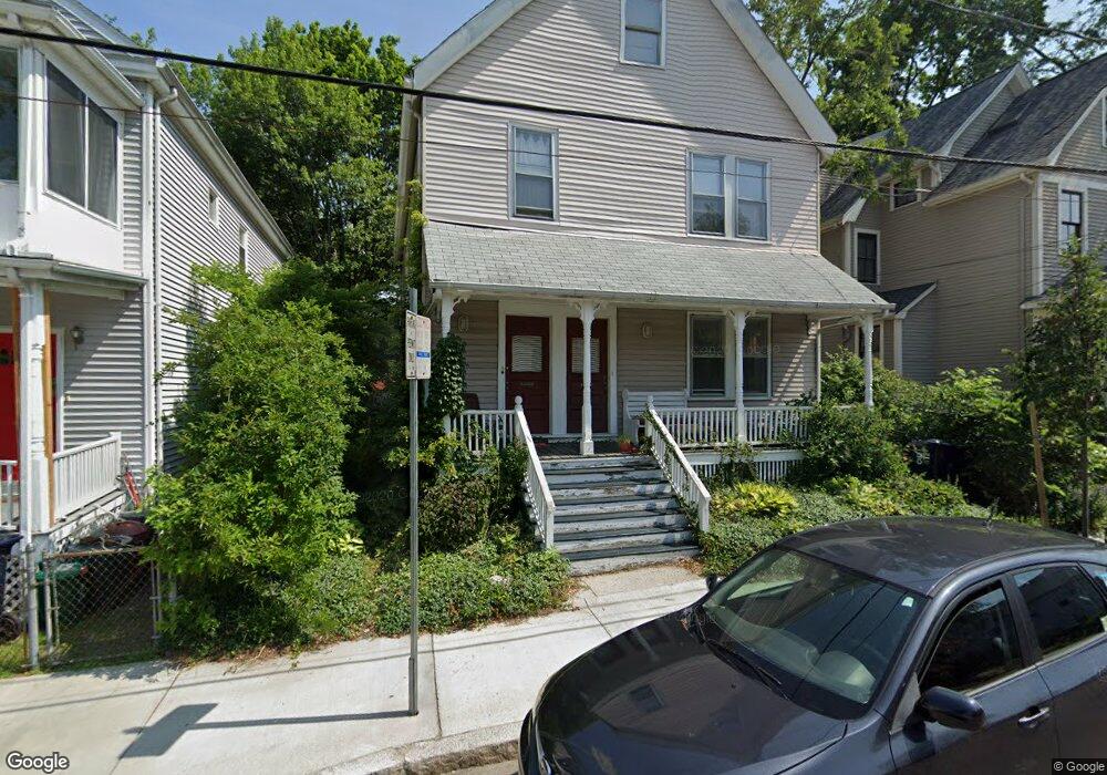
57 Hubbard Ave Unit 59 Cambridge, MA 02140
Neighborhood Nine NeighborhoodEstimated Value: $1,680,000 - $1,891,000
3
Beds
3
Baths
2,570
Sq Ft
$693/Sq Ft
Est. Value
About This Home
This home is located at 57 Hubbard Ave Unit 59, Cambridge, MA 02140 and is currently estimated at $1,781,687, approximately $693 per square foot. 57 Hubbard Ave Unit 59 is a home located in Middlesex County with nearby schools including Benjamin Banneker Charter Public School, Cambridge Montessori School, and Cambridge Friends School.
Ownership History
Date
Name
Owned For
Owner Type
Purchase Details
Closed on
Sep 13, 2016
Sold by
Morrison Paul A
Bought by
Paul A Morrison Lt
Current Estimated Value
Purchase Details
Closed on
May 13, 1994
Sold by
Pierce Robert S
Bought by
Morrison Paul A
Create a Home Valuation Report for This Property
The Home Valuation Report is an in-depth analysis detailing your home's value as well as a comparison with similar homes in the area
Home Values in the Area
Average Home Value in this Area
Purchase History
| Date | Buyer | Sale Price | Title Company |
|---|---|---|---|
| Paul A Morrison Lt | -- | -- | |
| Morrison Paul A | $175,000 | -- | |
| Morrison Paul A | $175,000 | -- |
Source: Public Records
Mortgage History
| Date | Status | Borrower | Loan Amount |
|---|---|---|---|
| Previous Owner | Morrison Paul A | $154,000 |
Source: Public Records
Tax History Compared to Growth
Tax History
| Year | Tax Paid | Tax Assessment Tax Assessment Total Assessment is a certain percentage of the fair market value that is determined by local assessors to be the total taxable value of land and additions on the property. | Land | Improvement |
|---|---|---|---|---|
| 2025 | $9,061 | $1,426,900 | $758,200 | $668,700 |
| 2024 | $8,489 | $1,434,000 | $790,400 | $643,600 |
| 2023 | $8,061 | $1,375,600 | $808,300 | $567,300 |
| 2022 | $7,721 | $1,304,300 | $792,300 | $512,000 |
| 2021 | $7,434 | $1,270,700 | $775,400 | $495,300 |
| 2020 | $7,208 | $1,253,500 | $767,700 | $485,800 |
| 2019 | $6,671 | $1,123,000 | $666,100 | $456,900 |
| 2018 | $4,485 | $1,028,000 | $617,000 | $411,000 |
| 2017 | $6,503 | $1,002,000 | $589,000 | $413,000 |
| 2016 | $6,248 | $893,800 | $508,300 | $385,500 |
| 2015 | $5,791 | $740,600 | $399,600 | $341,000 |
| 2014 | $5,339 | $637,100 | $333,000 | $304,100 |
Source: Public Records
Map
Nearby Homes
- 8 Cogswell Ave
- 24 Cambridge Terrace Unit 2
- 61 Bolton St Unit 304
- 86 Avon Hill St
- 12 Rindge Ave Unit 1
- 273 Walden St Unit 2
- 1 Richdale Ave Unit 2
- 147 Sherman St Unit 201
- 179 Rindge Ave Unit 1
- 7 Beech St Unit 319
- 7 Beech St Unit 211
- 183 Rindge Ave Unit 1
- 18 Donnell St
- 43 Linnaean St Unit 42
- 22 Agassiz St
- 12-14 Gray Gardens W
- 84 Garden St
- 5 Field St
- 3 Arlington St Unit 52
- 148 Huron Ave
- 53-55 Hubbard Ave Unit 53
- 55 Hubbard Ave
- 53 Hubbard Ave
- 55 Hubbard Ave Unit 2
- 61 Hubbard Ave
- 189 Raymond St
- 51 Hubbard Ave Unit 2
- 49 Hubbard Ave Unit 51
- 49 Hubbard Ave Unit 1
- 186 Richdale Ave Unit 188
- 186 Richdale Ave Unit 188
- 186 Richdale Ave Unit 1
- 182 Richdale Ave Unit 184
- 188 Richdale Ave Unit 2,188
- 188 Richdale Ave Unit 1, 188
- 62 Hubbard Ave
- 178 Richdale Ave Unit 1R
- 176 Richdale Ave Unit 3L
- 202 Richdale Ave Unit 3
- 202 Richdale Ave Unit 2