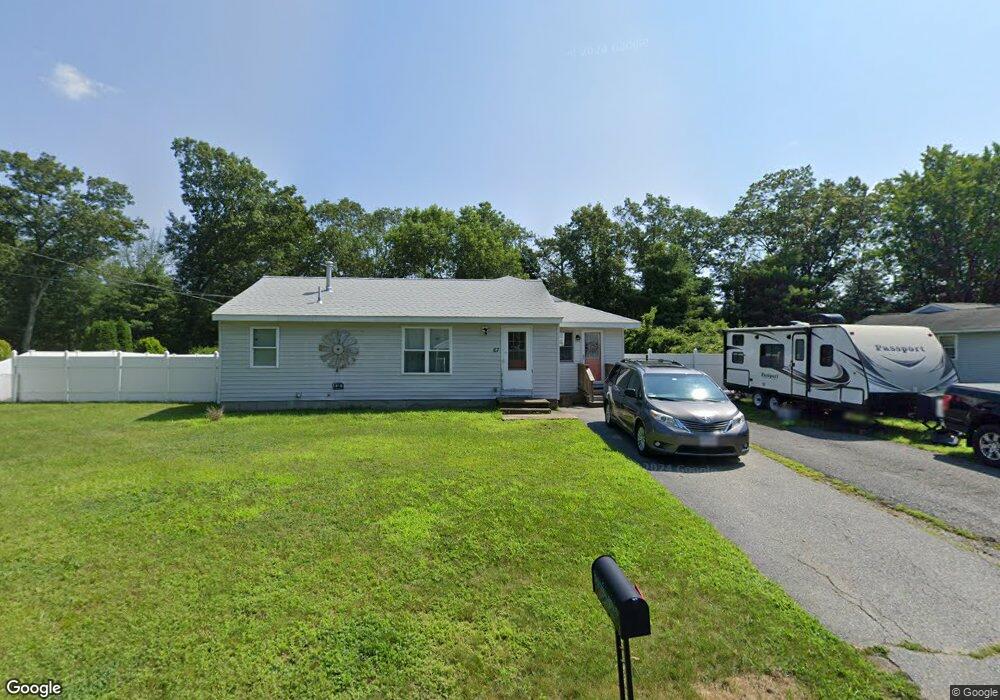
57 Laura Ln Whitinsville, MA 01588
Estimated Value: $357,174 - $384,000
3
Beds
1
Bath
816
Sq Ft
$461/Sq Ft
Est. Value
About This Home
This home is located at 57 Laura Ln, Whitinsville, MA 01588 and is currently estimated at $376,044, approximately $460 per square foot. 57 Laura Ln is a home located in Worcester County with nearby schools including Northbridge Elementary School, Northbridge Middle School, and Northbridge High School.
Ownership History
Date
Name
Owned For
Owner Type
Purchase Details
Closed on
Nov 2, 2023
Sold by
Barrows Ralph E and Froment Kristine A
Bought by
57 Laura Lane T and 57 Froment
Current Estimated Value
Purchase Details
Closed on
Oct 7, 2004
Sold by
Barrows Carolyn A and Barrows Ralph F
Bought by
Barrows Carolyn A and Froment Kristine A
Create a Home Valuation Report for This Property
The Home Valuation Report is an in-depth analysis detailing your home's value as well as a comparison with similar homes in the area
Home Values in the Area
Average Home Value in this Area
Purchase History
| Date | Buyer | Sale Price | Title Company |
|---|---|---|---|
| 57 Laura Lane T | -- | None Available | |
| 57 Laura Lane T | -- | None Available | |
| 57 Laura Lane T | -- | None Available | |
| Barrows Carolyn A | -- | -- | |
| Barrows Carolyn A | -- | -- |
Source: Public Records
Tax History Compared to Growth
Tax History
| Year | Tax Paid | Tax Assessment Tax Assessment Total Assessment is a certain percentage of the fair market value that is determined by local assessors to be the total taxable value of land and additions on the property. | Land | Improvement |
|---|---|---|---|---|
| 2025 | $3,661 | $310,500 | $137,200 | $173,300 |
| 2024 | $3,600 | $297,800 | $137,200 | $160,600 |
| 2023 | $3,744 | $288,900 | $137,200 | $151,700 |
| 2022 | $3,310 | $240,400 | $105,600 | $134,800 |
| 2021 | $3,117 | $215,100 | $100,500 | $114,600 |
| 2020 | $2,909 | $210,200 | $100,500 | $109,700 |
| 2019 | $2,647 | $204,100 | $100,500 | $103,600 |
| 2018 | $2,516 | $194,400 | $95,700 | $98,700 |
| 2017 | $2,531 | $187,100 | $95,700 | $91,400 |
| 2016 | $2,390 | $173,800 | $87,000 | $86,800 |
| 2015 | $2,157 | $161,200 | $73,900 | $87,300 |
| 2014 | $2,138 | $161,200 | $73,900 | $87,300 |
Source: Public Records
Map
Nearby Homes
- 1052 Providence Rd
- 169 Rolling Ridge Dr Unit 97
- 140 Rolling Ridge Dr Unit 78
- 159 Rolling Ridge Dr Unit 85
- 39 Crestwood Cir Unit 42
- 33 Crestwood Cir Unit 45
- 831 Providence Rd Unit 837
- 157 Rolling Ridge Dr Unit 84
- 5 Summit St
- 21 Granite St
- 121 East St Unit 121
- 894 Marston Rd
- 708 Marston Rd
- 90 Nathaniel Dr
- 18 East St Unit 24
- 0 Puddon St
- Lots 1-9 Spring St
- 128 Linwood Ave
- next 191 Mendon Rd
- 192 Rebecca Rd
- 49 Laura Ln
- 67 Laura Ln
- 56 Laura Ln
- 68 Laura Ln
- 79 Laura Ln
- 44 Laura Ln
- 78 Laura Ln
- 29 Laura Ln
- 91 Laura Ln
- 90 Laura Ln
- 24 Laura Ln
- 1014 Providence Rd
- 1040 Providence Rd
- 1024 Providence Rd
- 34 Plummer Park
- 1004 Providence Rd
- 38 Plummer Park
- 1066 Providence Rd Unit 1068
- 28 Plummer Park
- 1031 Providence Rd