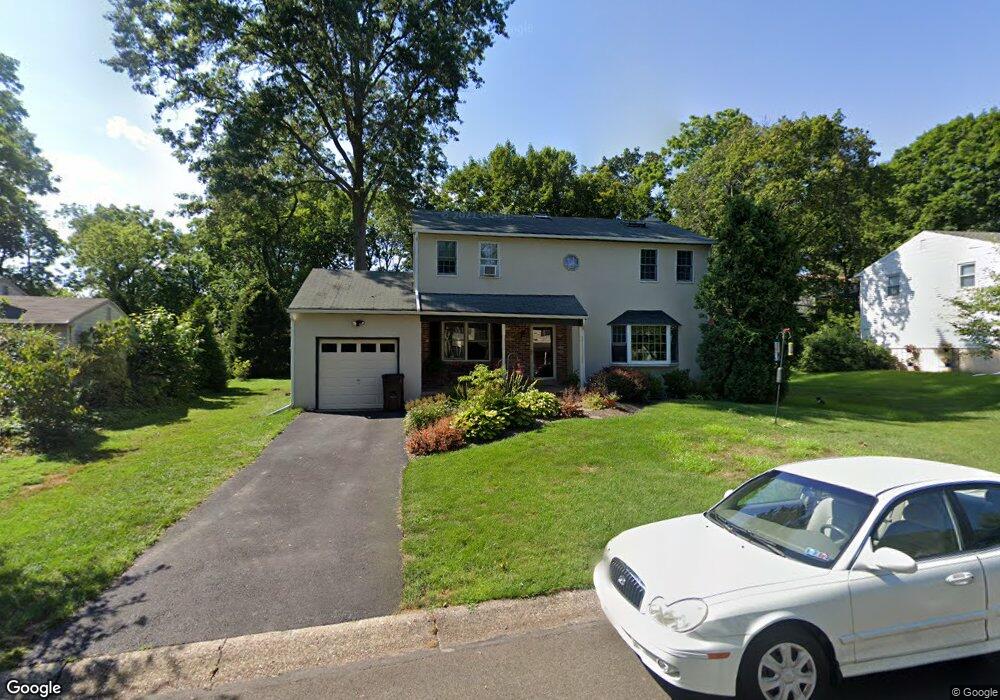
57 Meadow Ln Doylestown, PA 18901
Estimated Value: $803,055 - $952,000
5
Beds
4
Baths
2,510
Sq Ft
$352/Sq Ft
Est. Value
About This Home
This home is located at 57 Meadow Ln, Doylestown, PA 18901 and is currently estimated at $884,514, approximately $352 per square foot. 57 Meadow Ln is a home located in Bucks County with nearby schools including Linden El School, Lenape Middle School, and Central Bucks High School-West.
Ownership History
Date
Name
Owned For
Owner Type
Purchase Details
Closed on
Jun 19, 1997
Sold by
Moyer Rodney C and Moyer Suzzanne P
Bought by
Lander Jonathan H and Lander Beth Myers
Current Estimated Value
Home Financials for this Owner
Home Financials are based on the most recent Mortgage that was taken out on this home.
Original Mortgage
$175,700
Outstanding Balance
$24,775
Interest Rate
7.81%
Estimated Equity
$859,739
Purchase Details
Closed on
Sep 9, 1988
Bought by
Moyer Rodney C and Moyer Suzzanne P
Create a Home Valuation Report for This Property
The Home Valuation Report is an in-depth analysis detailing your home's value as well as a comparison with similar homes in the area
Home Values in the Area
Average Home Value in this Area
Purchase History
| Date | Buyer | Sale Price | Title Company |
|---|---|---|---|
| Lander Jonathan H | $185,000 | Commonwealth Land Title Ins | |
| Moyer Rodney C | $193,500 | -- |
Source: Public Records
Mortgage History
| Date | Status | Borrower | Loan Amount |
|---|---|---|---|
| Open | Lander Jonathan H | $175,700 |
Source: Public Records
Tax History Compared to Growth
Tax History
| Year | Tax Paid | Tax Assessment Tax Assessment Total Assessment is a certain percentage of the fair market value that is determined by local assessors to be the total taxable value of land and additions on the property. | Land | Improvement |
|---|---|---|---|---|
| 2025 | $6,278 | $34,850 | $6,320 | $28,530 |
| 2024 | $6,278 | $34,850 | $6,320 | $28,530 |
| 2023 | $5,981 | $34,850 | $6,320 | $28,530 |
| 2022 | $5,898 | $34,850 | $6,320 | $28,530 |
| 2021 | $5,834 | $34,850 | $6,320 | $28,530 |
| 2020 | $5,769 | $34,850 | $6,320 | $28,530 |
| 2019 | $5,706 | $34,850 | $6,320 | $28,530 |
| 2018 | $5,636 | $34,850 | $6,320 | $28,530 |
| 2017 | $5,577 | $34,850 | $6,320 | $28,530 |
| 2016 | $5,577 | $34,850 | $6,320 | $28,530 |
| 2015 | -- | $34,850 | $6,320 | $28,530 |
| 2014 | -- | $34,850 | $6,320 | $28,530 |
Source: Public Records
Map
Nearby Homes
- 236 Green St
- 89 Homestead Dr
- 403 S Main St Unit S201
- 110 E Ashland St
- 3 Steeplechase Dr
- 195 Lafayette St
- 69 E Oakland Ave
- 155 E Oakland Ave
- 20 E Court St
- 37 N Clinton St
- 1 Barnes Ct
- 146 E Court St
- 339 E Ashland St
- 78 Tower Hill Rd
- 130 N Clinton St
- 272 Fox Chase Ln
- 146 N Church St
- 9 Mill Creek Dr
- 2320 Turk Rd
- 121 Cottage St