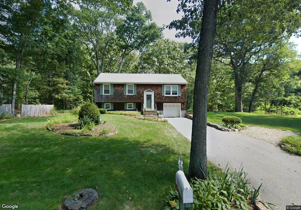
57 Shepard Rd Sturbridge, MA 01566
Estimated Value: $359,750 - $423,000
3
Beds
1
Bath
1,092
Sq Ft
$347/Sq Ft
Est. Value
About This Home
This home is located at 57 Shepard Rd, Sturbridge, MA 01566 and is currently estimated at $378,688, approximately $346 per square foot. 57 Shepard Rd is a home located in Worcester County with nearby schools including Burgess Elementary School, Tantasqua Regional Junior High School, and Tantasqua Regional High School.
Ownership History
Date
Name
Owned For
Owner Type
Purchase Details
Closed on
Feb 2, 2023
Sold by
Vangel-Brousseau Ellen
Bought by
E Vangel-Brousseau Ret
Current Estimated Value
Purchase Details
Closed on
Nov 16, 2020
Sold by
Brousseau Edward C and Vangel-Brousseau Ellen
Bought by
Brousseau Edward C and Vangel-Brousseau Ellen
Purchase Details
Closed on
Oct 29, 1982
Bought by
Brousseau Edward C
Create a Home Valuation Report for This Property
The Home Valuation Report is an in-depth analysis detailing your home's value as well as a comparison with similar homes in the area
Home Values in the Area
Average Home Value in this Area
Purchase History
| Date | Buyer | Sale Price | Title Company |
|---|---|---|---|
| E Vangel-Brousseau Ret | -- | None Available | |
| Brousseau Edward C | -- | None Available | |
| Brousseau Edward C | -- | -- |
Source: Public Records
Mortgage History
| Date | Status | Borrower | Loan Amount |
|---|---|---|---|
| Previous Owner | Brousseau Edward C | $40,000 | |
| Previous Owner | Brousseau Edward C | $37,000 |
Source: Public Records
Tax History
| Year | Tax Paid | Tax Assessment Tax Assessment Total Assessment is a certain percentage of the fair market value that is determined by local assessors to be the total taxable value of land and additions on the property. | Land | Improvement |
|---|---|---|---|---|
| 2025 | $4,913 | $308,400 | $100,700 | $207,700 |
| 2024 | $4,752 | $288,200 | $98,700 | $189,500 |
| 2023 | $4,496 | $248,800 | $86,100 | $162,700 |
| 2022 | $4,314 | $225,300 | $77,600 | $147,700 |
| 2021 | $3,827 | $201,200 | $73,900 | $127,300 |
| 2020 | $3,789 | $199,200 | $73,900 | $125,300 |
| 2019 | $3,677 | $192,000 | $76,300 | $115,700 |
| 2018 | $3,631 | $186,800 | $72,600 | $114,200 |
| 2017 | $3,461 | $178,400 | $69,800 | $108,600 |
| 2016 | $3,321 | $172,900 | $67,700 | $105,200 |
| 2015 | $3,123 | $162,300 | $67,700 | $94,600 |
Source: Public Records
Map
Nearby Homes
- 69 Farquhar Rd
- 8 Blueberry Ln
- 74 Fairview Park Rd
- 55 Fiske Hill Rd
- Lot 1 Berry Farms Road-2 Acre
- 74 River Rd
- 200 Main St
- 170 Shepard Rd
- 6 Berry Farms Rd Unit 3
- 6 Berry Farms Rd Unit 63
- 6 Berry Farms Rd Unit 64
- 6 Berry Farms Rd Unit 6
- 3 Berry Farms Road - Jv
- Lot B-6 River Rd
- 107 Wallace Rd
- 86 Old Sturbridge Rd
- 39 Park Ave
- 43 Park Ave
- 402 Pleasant Pkwy
- 222 Park Cir