Estimated Value: $506,814 - $885,000
3
Beds
2
Baths
1,791
Sq Ft
$383/Sq Ft
Est. Value
About This Home
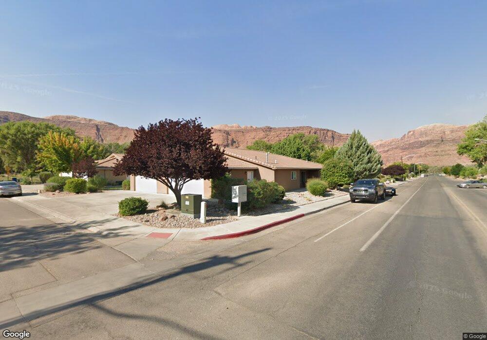
This home is located at 57 Shields Ln Unit 16B, Moab, UT 84532 and is currently estimated at $685,704, approximately $382 per square foot. 57 Shields Ln Unit 16B is a home located in Grand County with nearby schools including Helen M. Knight School, Grand County Middle School, and Grand County High School.
Ownership History
Date
Name
Owned For
Owner Type
Purchase Details
Closed on
Sep 10, 2014
Sold by
William R William R and Shuster Jacklyn M
Bought by
The Shuster Family Living Trust
Current Estimated Value
Purchase Details
Closed on
Mar 26, 2010
Sold by
Keogh Timothy M and Keogh Alies
Bought by
Shuster William R and Shuster Jacklyn M
Home Financials for this Owner
Home Financials are based on the most recent Mortgage that was taken out on this home.
Original Mortgage
$234,000
Interest Rate
4.88%
Mortgage Type
New Conventional
Create a Home Valuation Report for This Property
The Home Valuation Report is an in-depth analysis detailing your home's value as well as a comparison with similar homes in the area
Home Values in the Area
Average Home Value in this Area
Purchase History
| Date | Buyer | Sale Price | Title Company |
|---|---|---|---|
| The Shuster Family Living Trust | -- | Sloan Law Firm | |
| Shuster William R | -- | -- |
Source: Public Records
Mortgage History
| Date | Status | Borrower | Loan Amount |
|---|---|---|---|
| Previous Owner | Shuster William R | $234,000 |
Source: Public Records
Tax History Compared to Growth
Tax History
| Year | Tax Paid | Tax Assessment Tax Assessment Total Assessment is a certain percentage of the fair market value that is determined by local assessors to be the total taxable value of land and additions on the property. | Land | Improvement |
|---|---|---|---|---|
| 2025 | $1,019 | $551,313 | $100,000 | $451,313 |
| 2024 | $1,019 | $551,313 | $100,000 | $451,313 |
| 2023 | $1,965 | $551,313 | $100,000 | $451,313 |
| 2022 | $1,726 | $391,250 | $80,000 | $311,250 |
| 2021 | $3,683 | $339,375 | $80,000 | $259,375 |
| 2020 | $3,821 | $339,375 | $80,000 | $259,375 |
| 2019 | $1,984 | $339,375 | $80,000 | $259,375 |
| 2018 | $1,966 | $339,375 | $80,000 | $259,375 |
| 2017 | $1,725 | $0 | $0 | $0 |
| 2016 | $1,707 | $0 | $0 | $0 |
| 2015 | $1,697 | $0 | $0 | $0 |
| 2014 | $1,634 | $0 | $0 | $0 |
| 2013 | $1,636 | $158,125 | $0 | $0 |
Source: Public Records
Map
Nearby Homes
- 275 Williams Way Unit 1-5
- 396 W 200 S
- 279 Park Rd
- 100 W 200 S Unit 218
- 100 W 200 S Unit 118
- 67 S 100 W
- 276 N Opal Ave
- 168 S 100 W
- 212 N 100 W Unit 212
- 247 W 400 N Unit 1
- 24 W 200 N
- 57 E Center St Unit 1
- 57 E Center St Unit 2
- 94 E 100 N
- 72 E 200 N
- 476 Cliffview Dr
- 709 Bartlett Cir
- 443 Kane Creek Blvd Unit 211
- 443 Kane Creek Blvd Unit 111
- 443 Kane Creek Blvd Unit A104
- 57 Shields Ln
- 51 Shields Ln
- 45 Shields Ln
- 323 Williams Way
- 41 Shields Ln
- 335 Williams Way
- 339 Williams Way
- 290 Williams Way Unit 81
- 343 Williams Way
- 285 Williams Way
- 347 Williams Way
- 283 Williams Way
- 355 Williams Way
- 359 Williams Way
- 365 Williams Way Unit 3A
- 365 Williams Way
- 240 W Center St
- 369 Williams Way
- 255 Williams Way
- 377 Williams Way