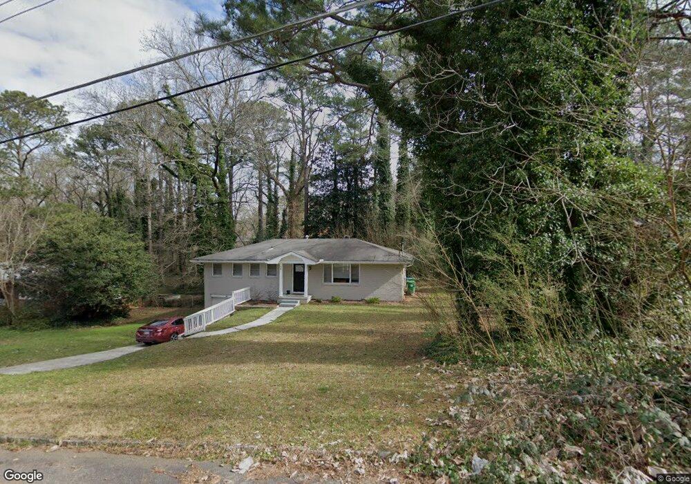
570 Kenridge Cir Unit 1 Stone Mountain, GA 30083
Estimated Value: $206,000 - $212,000
3
Beds
2
Baths
1,274
Sq Ft
$163/Sq Ft
Est. Value
About This Home
This home is located at 570 Kenridge Cir Unit 1, Stone Mountain, GA 30083 and is currently estimated at $207,608, approximately $162 per square foot. 570 Kenridge Cir Unit 1 is a home located in DeKalb County with nearby schools including Allgood Elementary School, Freedom Middle School, and Clarkston High School.
Ownership History
Date
Name
Owned For
Owner Type
Purchase Details
Closed on
Aug 1, 2025
Sold by
Star 2021 Sfr2 Borrower Lp
Bought by
Sfr Tb Owner Lp
Current Estimated Value
Purchase Details
Closed on
Dec 14, 2021
Sold by
Sfr Atl Owner 4 Lp
Bought by
Star 2021 Sfr2 Borrower Lp
Purchase Details
Closed on
Apr 30, 2019
Sold by
Marx & Campbell Properties Llc
Bought by
Sfr Atl Owner 4 Lp
Purchase Details
Closed on
Jan 31, 2012
Sold by
Marx Conrad
Bought by
Marx & Campbell Properties Llc
Purchase Details
Closed on
Oct 1, 2003
Sold by
Ellington Horace J and Ellington Carolyn
Bought by
Campbell Jeff
Purchase Details
Closed on
Mar 10, 1997
Sold by
Jones Donald Porter
Bought by
Ellington Hhorace J and Ellington Carolyn
Create a Home Valuation Report for This Property
The Home Valuation Report is an in-depth analysis detailing your home's value as well as a comparison with similar homes in the area
Home Values in the Area
Average Home Value in this Area
Purchase History
| Date | Buyer | Sale Price | Title Company |
|---|---|---|---|
| Sfr Tb Owner Lp | -- | -- | |
| Star 2021 Sfr2 Borrower Lp | -- | -- | |
| Sfr Atl Owner 4 Lp | $132,500 | -- | |
| Marx & Campbell Properties Llc | -- | -- | |
| Campbell Jeff | $100,000 | -- | |
| Ellington Hhorace J | $77,900 | -- |
Source: Public Records
Mortgage History
| Date | Status | Borrower | Loan Amount |
|---|---|---|---|
| Closed | Ellington Hhorace J | -- |
Source: Public Records
Tax History Compared to Growth
Tax History
| Year | Tax Paid | Tax Assessment Tax Assessment Total Assessment is a certain percentage of the fair market value that is determined by local assessors to be the total taxable value of land and additions on the property. | Land | Improvement |
|---|---|---|---|---|
| 2025 | $4,656 | $96,000 | $24,000 | $72,000 |
| 2024 | $4,654 | $96,000 | $24,000 | $72,000 |
| 2023 | $4,654 | $96,000 | $24,000 | $72,000 |
| 2022 | $3,564 | $73,240 | $15,000 | $58,240 |
| 2021 | $2,678 | $53,040 | $15,000 | $38,040 |
| 2020 | $2,356 | $45,720 | $2,960 | $42,760 |
| 2019 | $1,438 | $24,800 | $2,480 | $22,320 |
| 2018 | $1,167 | $24,800 | $2,480 | $22,320 |
| 2017 | $1,483 | $29,480 | $2,960 | $26,520 |
| 2016 | $1,446 | $24,800 | $2,960 | $21,840 |
| 2014 | $902 | $12,200 | $2,960 | $9,240 |
Source: Public Records
Map
Nearby Homes
- 570 Kenridge Cir
- 579 Kenridge Cir
- 4210 Rockbridge Rd
- 4116 Warrior Trail Unit 2
- 4328 Rockbridge Rd
- 4096 Warrior Trail
- 4250 Village Square Ln
- 4134 Blackhawk Dr
- 613 Rays Rd
- 494 Rue Montaigne
- 573 Hambrick Square
- 539 Rue Montaigne
- 550 S Rays (9 74 Acres) Rd
- 550 S Rays (8 6 Acres) Rd
- 522 Windchase Ln Unit 522
- 440 Sheppard Xing Ct
- 550 S Rays Rd
- 549 Windchase Ln
- 6552 Old Hampton Dr Unit 6552
- 521 S Indian Creek Dr
- 576 Kenridge Cir
- 562 Kenridge Cir
- 4130 Rockbridge Heights Dr
- 584 Kenridge Cir Unit III
- 4122 Rockbridge Heights Dr
- 554 Kenridge Cir
- 4138 Rockbridge Heights Dr
- 4114 Rockbridge Heights Dr
- 565 Kenridge Cir Unit 3
- 573 Kenridge Cir
- 590 Kenridge Cir
- 557 Kenridge Cir Unit 3
- 548 Kenridge Cir Unit 3
- 0 Kenridge Cir Unit 8510385
- 0 Kenridge Cir Unit 8247879
- 0 Kenridge Cir Unit 8207587
- 0 Kenridge Cir Unit 8028661
- 0 Kenridge Cir Unit 9066997
- 0 Kenridge Cir Unit 3166202
- 0 Kenridge Cir Unit 3166670