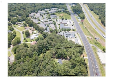
5700 Highway 20 SE Cartersville, GA 30121
Estimated payment $3,264/month
4.11
Acres
$145,985
Price per Acre
179,032
Sq Ft Lot
Highlights
- 4.11 Acre Lot
- Partially Wooded Lot
- Restaurant
- Ranch Style House
About This Lot
4+ acres with over 300 feet of road frontage on Highway 20. Under 1 mile from Exit 290 (I-75N). Traffic count is over 20,000 vehicles per day. Visible from Interstate. Potential commercial use for restaurant, Hotel, Quick shop, offices.
Property Details
Property Type
- Land
Est. Annual Taxes
- $1,296
Year Built
- Built in 1958
Lot Details
- 4.11 Acre Lot
- Lot Dimensions are 300x321x562x511
- Property fronts a state road
- Partially Wooded Lot
- Property is zoned A1
Home Design
- Ranch Style House
- Fixer Upper
Bedrooms and Bathrooms
- 3 Main Level Bedrooms
- 1 Full Bathroom
Schools
- Cloverleaf Elementary School
- Red Top Middle School
- Cass High School
Utilities
- Phone Available
- Cable TV Available
Community Details
- Restaurant
Map
Create a Home Valuation Report for This Property
The Home Valuation Report is an in-depth analysis detailing your home's value as well as a comparison with similar homes in the area
Home Values in the Area
Average Home Value in this Area
Tax History
| Year | Tax Paid | Tax Assessment Tax Assessment Total Assessment is a certain percentage of the fair market value that is determined by local assessors to be the total taxable value of land and additions on the property. | Land | Improvement |
|---|---|---|---|---|
| 2024 | $1,778 | $61,792 | $30,384 | $31,408 |
| 2023 | $1,502 | $53,132 | $21,790 | $31,342 |
| 2022 | $1,339 | $52,727 | $21,385 | $31,342 |
| 2021 | $1,161 | $43,516 | $21,385 | $22,131 |
| 2020 | $1,195 | $43,516 | $21,385 | $22,131 |
| 2019 | $926 | $33,358 | $18,216 | $15,142 |
| 2018 | $725 | $26,040 | $12,920 | $13,120 |
| 2017 | $729 | $26,040 | $12,920 | $13,120 |
| 2016 | $735 | $26,040 | $12,920 | $13,120 |
| 2015 | $730 | $25,840 | $12,920 | $12,920 |
| 2014 | $708 | $24,280 | $12,920 | $11,360 |
| 2013 | -- | $22,200 | $12,920 | $9,280 |
Source: Public Records
Property History
| Date | Event | Price | List to Sale | Price per Sq Ft |
|---|---|---|---|---|
| 11/30/2025 11/30/25 | For Sale | $600,000 | -- | -- |
Source: First Multiple Listing Service (FMLS)
Source: First Multiple Listing Service (FMLS)
MLS Number: 7691162
APN: 0091-0306-004
Nearby Homes
- 0 Simpson Cir NE Unit 7686966
- 40 Azalea Dr SE
- 204 Simpson Cir NE
- 30 Grand Georgian Ct NE
- 0 Highway 20 Unit 7684784
- 12 Ranger Rd SE
- 22 Treemont Dr SE
- 90 Smiley Ingram Rd SE
- 25 Treemont Dr SE
- 17 W Ridge Dr SE
- 34 Laurel Way NE
- 17 Pinoak Trail
- 31 Churchill Downs NE
- 00 Lewis Rd
- 22 Churchill Downs NE
- 27 Berryhill Place SE
- 10 Berryhill Place
- 25 Mallet Pointe NE
- 23 Equestrian Way NE
- 84 Cline-Smith Rd
- 50 Stone Mill Dr SE
- 29 Dean Rd SE Unit ID1234802P
- 29 Dean Rd SE
- 17 Rock Crest Cir SE Unit ID1234819P
- 17 Rock Crest Cir SE
- 91 Somerset Club Dr SE Unit 223
- 91 Somerset Club Dr SE Unit 420
- 27 W Ridge Dr SE Unit ID1234835P
- 27 W Ridge Dr SE
- 102 Fairlie Pkwy
- 102 Fairlie Pkwy Unit Avalon
- 102 Fairlie Pkwy Unit Elijah
- 102 Fairlie Pkwy Unit Stapleton
- Interstate 75
- 5610 Highway 20 NE
- 246 Dupont Dr
- 700 Shetland Trail
- 702 Shetland Trail
- 701 Shetland Trail
- 316 Skye Ln


