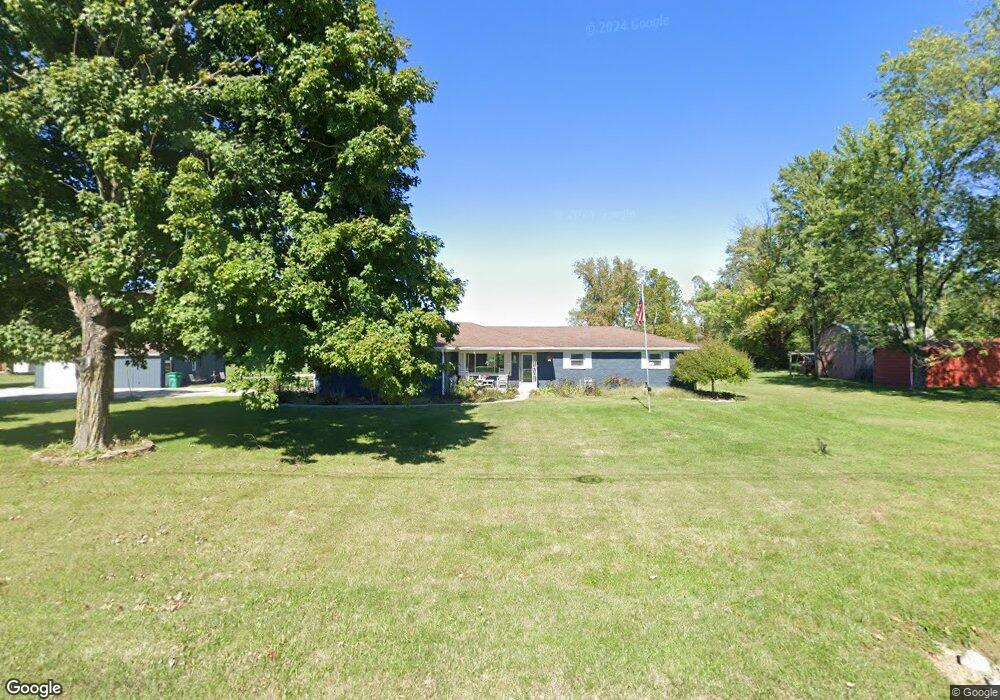
5702 E Landersdale Rd Camby, IN 46113
Estimated Value: $280,000 - $338,313
3
Beds
2
Baths
1,508
Sq Ft
$199/Sq Ft
Est. Value
About This Home
This home is located at 5702 E Landersdale Rd, Camby, IN 46113 and is currently estimated at $300,438, approximately $199 per square foot. 5702 E Landersdale Rd is a home located in Morgan County with nearby schools including Mooresville High School and Mooresville Christian Academy.
Ownership History
Date
Name
Owned For
Owner Type
Purchase Details
Closed on
Sep 21, 2009
Sold by
Scarbrough John David and Butler Barbara Jean
Bought by
Johns Larry J and Johns Ruth A
Current Estimated Value
Home Financials for this Owner
Home Financials are based on the most recent Mortgage that was taken out on this home.
Original Mortgage
$97,000
Outstanding Balance
$62,821
Interest Rate
5.32%
Mortgage Type
New Conventional
Estimated Equity
$237,617
Purchase Details
Closed on
Mar 28, 2008
Sold by
Scarbrough Amos D
Bought by
Scarborough John David and Butler Barbara Jean
Purchase Details
Closed on
Feb 22, 2008
Sold by
Scarbrough Amos D and Scarbrough Marjorie L
Bought by
Scarbrough Amos D
Create a Home Valuation Report for This Property
The Home Valuation Report is an in-depth analysis detailing your home's value as well as a comparison with similar homes in the area
Home Values in the Area
Average Home Value in this Area
Purchase History
| Date | Buyer | Sale Price | Title Company |
|---|---|---|---|
| Johns Larry J | -- | None Available | |
| Scarborough John David | -- | -- | |
| Scarbrough Amos D | -- | -- |
Source: Public Records
Mortgage History
| Date | Status | Borrower | Loan Amount |
|---|---|---|---|
| Open | Johns Larry J | $97,000 |
Source: Public Records
Tax History
| Year | Tax Paid | Tax Assessment Tax Assessment Total Assessment is a certain percentage of the fair market value that is determined by local assessors to be the total taxable value of land and additions on the property. | Land | Improvement |
|---|---|---|---|---|
| 2025 | $554 | $290,700 | $105,900 | $184,800 |
| 2024 | $554 | $291,800 | $105,900 | $185,900 |
| 2023 | $678 | $285,500 | $105,900 | $179,600 |
| 2022 | $681 | $251,900 | $105,900 | $146,000 |
| 2021 | $501 | $192,300 | $68,300 | $124,000 |
| 2020 | $505 | $188,500 | $68,300 | $120,200 |
| 2019 | $488 | $173,900 | $68,300 | $105,600 |
| 2018 | $616 | $164,700 | $68,300 | $96,400 |
| 2017 | $617 | $170,600 | $68,300 | $102,300 |
| 2016 | $614 | $170,600 | $68,300 | $102,300 |
| 2014 | $576 | $168,700 | $68,300 | $100,400 |
| 2013 | $576 | $170,800 | $68,300 | $102,500 |
Source: Public Records
Map
Nearby Homes
- 12756 N Commons East Dr
- 12754 N Commons East Dr
- 5406 E Commons North Dr
- 0 Martin North Ln
- 5452 E Hadley Rd
- 13026 N Becks Grove Dr
- 13174 N Departure Blvd E
- 5375 E Commons West Dr
- 6221 E Ayrshire Cir
- 0 N Oak Dr Unit MBR22087524
- 0 N Oak Dr Unit MBR22050808
- 12449 N Turner Rd
- 6030 E Terhune Ct
- 6411 E Ablington Ct
- 6181 E Solitude Ct
- 6300 E Runnymede Ct
- 13420 N Carefree Ct
- 1009 Honeysuckle Dr
- 13847 N Settle Way
- 6542 E Edna Mills Dr
- 5732 E Landersdale Rd
- 856 Landersdale Rd
- 5660 E Landersdale Rd
- 5730 Donald Dr E
- 5700 Donald Dr E
- 5680 E Donald Dr
- 5680 Donald Dr E
- 5720 Donald Dr E
- 5740 Donald Dr E
- 5760 Donald Dr E
- 5650 E Landersdale Rd
- 5770 Donald Dr E
- 5770 E Donald Dr
- 12940 John Charles Ct N
- 12945 Bridgett Dr N
- 5792 E Landersdale Rd
- 5620 E Landersdale Rd
- 5780 Donald Dr E
- 12930 John Charles Ct N
- 12945 John Charles Ct N
Your Personal Tour Guide
Ask me questions while you tour the home.