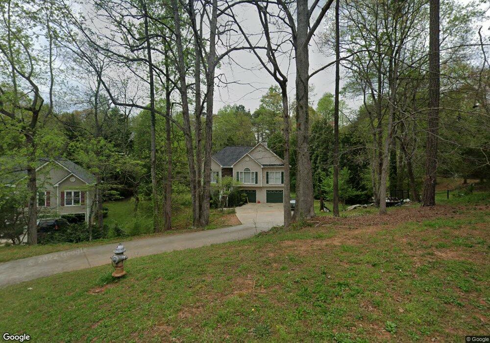
5708 Fir Ln Flowery Branch, GA 30542
Estimated Value: $342,000 - $401,000
3
Beds
2
Baths
1,636
Sq Ft
$225/Sq Ft
Est. Value
About This Home
This home is located at 5708 Fir Ln, Flowery Branch, GA 30542 and is currently estimated at $368,767, approximately $225 per square foot. 5708 Fir Ln is a home located in Hall County with nearby schools including Flowery Branch Elementary School, West Hall Middle School, and West Hall High School.
Ownership History
Date
Name
Owned For
Owner Type
Purchase Details
Closed on
May 6, 2003
Sold by
Mixon Rodney S and Mixon Karrie
Bought by
Household Bank Fsb
Current Estimated Value
Purchase Details
Closed on
Mar 8, 1996
Sold by
Great Southernresource Invest Michelle
Bought by
Mixon Rodney Karrie
Create a Home Valuation Report for This Property
The Home Valuation Report is an in-depth analysis detailing your home's value as well as a comparison with similar homes in the area
Home Values in the Area
Average Home Value in this Area
Purchase History
| Date | Buyer | Sale Price | Title Company |
|---|---|---|---|
| Household Bank Fsb | $148,492 | -- | |
| Mortgage Electroinic Registration System | -- | -- | |
| Mixon Rodney Karrie | $119,500 | -- |
Source: Public Records
Mortgage History
| Date | Status | Borrower | Loan Amount |
|---|---|---|---|
| Closed | Mixon Rodney Karrie | $0 |
Source: Public Records
Tax History Compared to Growth
Tax History
| Year | Tax Paid | Tax Assessment Tax Assessment Total Assessment is a certain percentage of the fair market value that is determined by local assessors to be the total taxable value of land and additions on the property. | Land | Improvement |
|---|---|---|---|---|
| 2024 | $2,673 | $103,080 | $8,800 | $94,280 |
| 2023 | $2,535 | $97,680 | $8,800 | $88,880 |
| 2022 | $2,450 | $90,440 | $8,800 | $81,640 |
| 2021 | $2,399 | $86,840 | $8,800 | $78,040 |
| 2020 | $2,374 | $83,440 | $8,800 | $74,640 |
| 2019 | $2,260 | $78,600 | $8,800 | $69,800 |
| 2018 | $1,679 | $65,120 | $8,800 | $56,320 |
| 2017 | $1,755 | $58,680 | $8,800 | $49,880 |
| 2016 | $1,583 | $53,834 | $8,714 | $45,120 |
| 2015 | $1,601 | $53,834 | $8,714 | $45,120 |
| 2014 | $1,601 | $63,620 | $8,714 | $54,906 |
Source: Public Records
Map
Nearby Homes
- 6024 Park Bay Ct
- 5432 Barberry Ave
- 5837 Meadow View Ln
- 4435 McBrayer Rd
- 5729 Jim Crow Rd
- 5580 Point West Dr
- 5610 Point Dr W
- 5457 Barberry Ave
- 5626 Sallee Ave
- 5867 Meadow View Ln
- 6135 White Oak Dr
- 6137 White Oak Dr
- 5348 Barberry Ave
- 5704 Sallee Cir
- 5724 Sallee Cir
- 5568 Foxglove Way
- 6025 River Oaks Dr
- 5712 Fir Ln
- 5704 Fir Ln
- 5670 Pipsissewa Dr
- 5707 Fir Ln
- 5632 Pipsissewa Dr
- 5603 Spruce Ln
- 5628 Pipsissewa Dr
- 5613 Spruce Ln
- 5716 Fir Ln
- 5607 Spruce Ln
- 5666 Pipsissewa Dr
- 6875 Spruce Ln
- 5711 Fir Ln
- 5636 Pipsissewa Dr
- 5710 Pipsissewa Dr
- 0 Pipsissewa Dr Unit 8486065
- 0 Pipsissewa Dr Unit 8335958
- 0 Pipsissewa Dr Unit 8332455
- 0 Pipsissewa Dr Unit 8033460
- 0 Pipsissewa Dr Unit 8822054