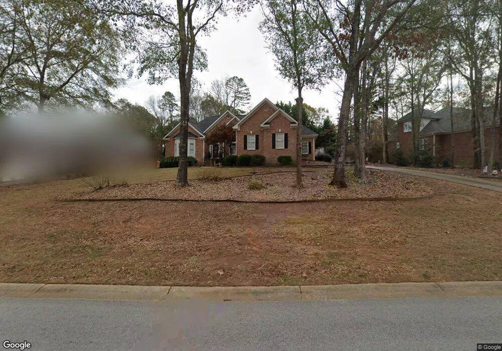
571 Chesterfield Rd Bogart, GA 30622
Estimated Value: $417,770 - $448,000
3
Beds
2
Baths
2,181
Sq Ft
$198/Sq Ft
Est. Value
About This Home
This home is located at 571 Chesterfield Rd, Bogart, GA 30622 and is currently estimated at $431,943, approximately $198 per square foot. 571 Chesterfield Rd is a home located in Clarke County with nearby schools including Cleveland Road Elementary School, Burney-Harris-Lyons Middle School, and Clarke Central High School.
Ownership History
Date
Name
Owned For
Owner Type
Purchase Details
Closed on
Aug 15, 2003
Sold by
Mccorkle Todd
Bought by
Oare Connie
Current Estimated Value
Purchase Details
Closed on
Dec 29, 2000
Sold by
Bradley Daniel
Bought by
Mccorkle Todd
Purchase Details
Closed on
Jul 10, 2000
Sold by
H & B Homes Llc
Bought by
Bradley Daniel
Purchase Details
Closed on
Mar 1, 2000
Sold by
Willwork L L C
Bought by
H & B Homes Llc
Create a Home Valuation Report for This Property
The Home Valuation Report is an in-depth analysis detailing your home's value as well as a comparison with similar homes in the area
Home Values in the Area
Average Home Value in this Area
Purchase History
| Date | Buyer | Sale Price | Title Company |
|---|---|---|---|
| Oare Connie | $216,000 | -- | |
| Mccorkle Todd | $208,900 | -- | |
| Bradley Daniel | $28,000 | -- | |
| H & B Homes Llc | $18,800 | -- |
Source: Public Records
Tax History Compared to Growth
Tax History
| Year | Tax Paid | Tax Assessment Tax Assessment Total Assessment is a certain percentage of the fair market value that is determined by local assessors to be the total taxable value of land and additions on the property. | Land | Improvement |
|---|---|---|---|---|
| 2025 | $3,035 | $169,936 | $18,000 | $151,936 |
| 2024 | $3,035 | $164,698 | $18,000 | $146,698 |
| 2023 | $3,063 | $154,315 | $18,000 | $136,315 |
| 2022 | $2,924 | $132,100 | $18,000 | $114,100 |
| 2021 | $2,770 | $109,400 | $16,000 | $93,400 |
| 2020 | $2,731 | $106,507 | $16,000 | $90,507 |
| 2019 | $2,622 | $96,958 | $16,000 | $80,958 |
| 2018 | $2,563 | $92,772 | $16,000 | $76,772 |
| 2017 | $2,482 | $86,912 | $16,000 | $70,912 |
| 2016 | $2,452 | $84,819 | $16,000 | $68,819 |
| 2015 | $2,405 | $81,426 | $16,000 | $65,426 |
| 2014 | $2,450 | $84,621 | $16,000 | $68,621 |
Source: Public Records
Map
Nearby Homes
- 682 Chesterfield Rd
- 190 W Huntington Rd
- 240 W Huntington Rd
- 100 Hanover Dr
- 212 Huntington Shoals Dr
- 241 Meeler Cir
- 141 Huntington Shoals Dr
- 637 Huntington Rd Unit B1
- 112 Deerhollow Rd
- 240 Deerfield Rd
- 470 Huntington Rd Unit 5
- 532 Huntington Rd Unit 7
- 256 Cherokee Ridge
- 150 Callaway Dr
- 575 Vaughn Rd
- 178 Ben Burton Cir
- 215 Claystone Trace
- 450 River Bottom Rd
- 561 Chesterfield Rd
- 581 Chesterfield Rd
- 145 Chelsea Ct
- 551 Chesterfield Rd
- 560 Chesterfield Rd
- 554 Chesterfield Rd
- 566 Chesterfield Rd
- 572 Chesterfield Rd
- 165 Chelsea Ct
- 548 Chesterfield Rd
- 601 Chesterfield Rd
- 582 Chesterfield Rd
- 541 Chesterfield Rd
- 140 Chelsea Ct
- 542 Chesterfield Rd
- 160 Chelsea Ct
- 600 Chesterfield Rd
- 536 Chesterfield Rd
- 187 Brittany Rd
- 611 Chesterfield Rd