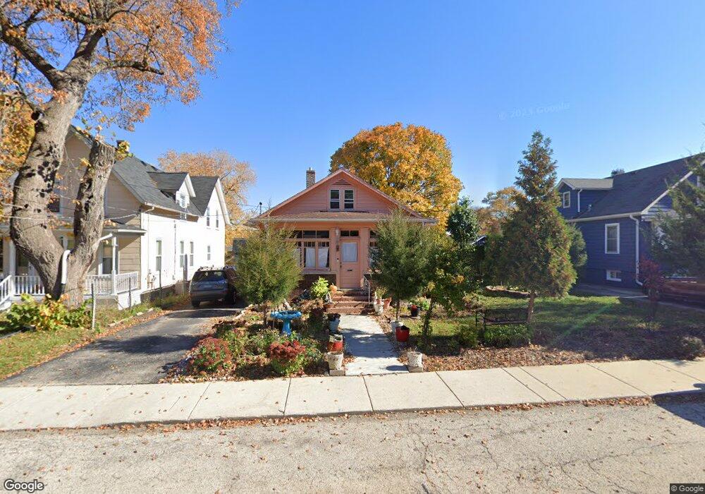
571 Mcclure Ave Elgin, IL 60123
Grant Park NeighborhoodEstimated Value: $254,000 - $269,690
2
Beds
1
Bath
1,248
Sq Ft
$210/Sq Ft
Est. Value
About This Home
This home is located at 571 Mcclure Ave, Elgin, IL 60123 and is currently estimated at $262,173, approximately $210 per square foot. 571 Mcclure Ave is a home located in Kane County with nearby schools including Highland Elementary School, Kimball Middle School, and Larkin High School.
Ownership History
Date
Name
Owned For
Owner Type
Purchase Details
Closed on
Jun 6, 2024
Sold by
Quintana Miguel G
Bought by
Bello Virginia G and Garcia Maximiano
Current Estimated Value
Purchase Details
Closed on
Nov 27, 1996
Sold by
Kugath Kevin A
Bought by
Garcia Maximiano and Bello Virginia
Home Financials for this Owner
Home Financials are based on the most recent Mortgage that was taken out on this home.
Original Mortgage
$106,167
Interest Rate
7.85%
Mortgage Type
FHA
Create a Home Valuation Report for This Property
The Home Valuation Report is an in-depth analysis detailing your home's value as well as a comparison with similar homes in the area
Home Values in the Area
Average Home Value in this Area
Purchase History
| Date | Buyer | Sale Price | Title Company |
|---|---|---|---|
| Bello Virginia G | -- | None Listed On Document | |
| Garcia Maximiano | $107,000 | -- |
Source: Public Records
Mortgage History
| Date | Status | Borrower | Loan Amount |
|---|---|---|---|
| Previous Owner | Garcia Maximiano | $106,167 |
Source: Public Records
Tax History
| Year | Tax Paid | Tax Assessment Tax Assessment Total Assessment is a certain percentage of the fair market value that is determined by local assessors to be the total taxable value of land and additions on the property. | Land | Improvement |
|---|---|---|---|---|
| 2024 | $5,668 | $74,858 | $15,100 | $59,758 |
| 2023 | $5,765 | $67,629 | $13,642 | $53,987 |
| 2022 | $5,347 | $61,666 | $12,439 | $49,227 |
| 2021 | $5,144 | $57,654 | $11,630 | $46,024 |
| 2020 | $5,020 | $55,040 | $11,103 | $43,937 |
| 2019 | $4,897 | $52,429 | $10,576 | $41,853 |
| 2018 | $4,368 | $44,181 | $9,963 | $34,218 |
| 2017 | $4,296 | $41,767 | $9,419 | $32,348 |
| 2016 | $4,133 | $38,748 | $8,738 | $30,010 |
| 2015 | -- | $35,516 | $8,009 | $27,507 |
| 2014 | -- | $35,077 | $7,910 | $27,167 |
| 2013 | -- | $39,367 | $8,119 | $31,248 |
Source: Public Records
Map
Nearby Homes
- 643 Wing St
- 336 Hamilton Ave
- 425 N Alfred Ave
- 302 Hubbard Ave
- 253 Mcclure Ave
- 164 Ludeka Place
- 121 Monroe Ave
- 705 W Highland Ave
- 308 N Clifton Ave
- 519 W Highland Ave
- 801 N Mclean Blvd Unit 320
- 801 N Mclean Blvd Unit 118
- 801 N Mclean Blvd Unit 124
- 801 N Mclean Blvd Unit 136
- 801 N Mclean Blvd Unit 222
- 801 N Mclean Blvd Unit 156
- 268 Seneca St
- 258 Ann St Unit 60
- 1059 Larkin Ave
- 9 N Jackson St
- 565 Mcclure Ave
- 575 Mcclure Ave
- 580 N Crystal St
- 557 Mcclure Ave
- 593 Mcclure Ave
- 709 Buckeye St
- 570 N Crystal St
- 564 N Crystal St
- 703 Buckeye St
- 570 Mcclure Ave
- 553 Mcclure Ave
- 564 Mcclure Ave
- 576 Mcclure Ave
- 558 Mcclure Ave
- 558 N Crystal St
- 755 Buckeye St
- 558 N Crystal Ave
- 550 Mcclure Ave
- 716 Buckeye St
- 765 Buckeye St
Your Personal Tour Guide
Ask me questions while you tour the home.