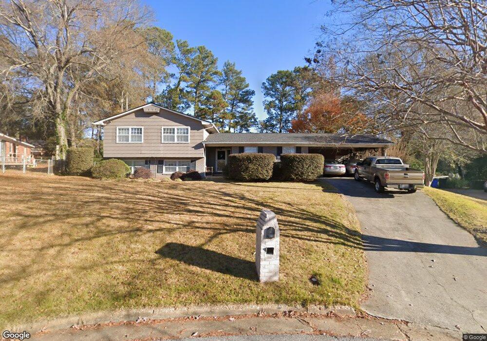
5712 Hastings Square Columbus, GA 31909
North Columbus NeighborhoodEstimated Value: $274,400 - $326,000
4
Beds
3
Baths
2,874
Sq Ft
$105/Sq Ft
Est. Value
About This Home
This home is located at 5712 Hastings Square, Columbus, GA 31909 and is currently estimated at $301,850, approximately $105 per square foot. 5712 Hastings Square is a home located in Muscogee County with nearby schools including Blanchard Elementary School, Veterans Memorial Middle School, and Hardaway High School.
Ownership History
Date
Name
Owned For
Owner Type
Purchase Details
Closed on
Jun 18, 2012
Sold by
Wells Fargo Bank
Bought by
Laskowski Samuel and Suhler Laskowsk Lisa
Current Estimated Value
Home Financials for this Owner
Home Financials are based on the most recent Mortgage that was taken out on this home.
Original Mortgage
$157,102
Outstanding Balance
$107,695
Interest Rate
3.6%
Mortgage Type
FHA
Estimated Equity
$194,155
Purchase Details
Closed on
Feb 7, 2012
Sold by
Boyd Christopher A
Bought by
Wells Fargo Bank Na Trustee
Create a Home Valuation Report for This Property
The Home Valuation Report is an in-depth analysis detailing your home's value as well as a comparison with similar homes in the area
Home Values in the Area
Average Home Value in this Area
Purchase History
| Date | Buyer | Sale Price | Title Company |
|---|---|---|---|
| Laskowski Samuel | $160,000 | -- | |
| Wells Fargo Bank Na Trustee | $147,003 | -- |
Source: Public Records
Mortgage History
| Date | Status | Borrower | Loan Amount |
|---|---|---|---|
| Open | Laskowski Samuel | $157,102 |
Source: Public Records
Tax History Compared to Growth
Tax History
| Year | Tax Paid | Tax Assessment Tax Assessment Total Assessment is a certain percentage of the fair market value that is determined by local assessors to be the total taxable value of land and additions on the property. | Land | Improvement |
|---|---|---|---|---|
| 2025 | $1,989 | $80,784 | $13,736 | $67,048 |
| 2024 | $1,988 | $80,784 | $13,736 | $67,048 |
| 2023 | $1,306 | $80,784 | $13,736 | $67,048 |
| 2022 | $2,073 | $64,652 | $13,736 | $50,916 |
| 2021 | $2,066 | $64,448 | $13,736 | $50,712 |
| 2020 | $2,067 | $64,448 | $13,736 | $50,712 |
| 2019 | $2,075 | $64,448 | $13,736 | $50,712 |
| 2018 | $2,075 | $64,448 | $13,736 | $50,712 |
| 2017 | $2,084 | $64,448 | $13,736 | $50,712 |
| 2016 | $2,093 | $64,000 | $10,128 | $53,872 |
| 2015 | $2,096 | $64,000 | $10,128 | $53,872 |
| 2014 | $2,099 | $64,000 | $10,128 | $53,872 |
| 2013 | -- | $64,000 | $10,128 | $53,872 |
Source: Public Records
Map
Nearby Homes
- 3710 Winkfield Place
- 5836 Sherborne Dr
- 3624 Southlea Ct
- 5921 Canterbury Dr
- 5531 Mariner Dr
- 6002 Canterbury Dr
- 3618 Grier Ave
- 5435 Wayne Dr
- 5829 Moon Rd
- 3091 Mustang Dr
- 5224 Miller Rd
- 3325 N North Quay Dr
- 6221 Charing Dr
- 3704 E Britt David Rd
- 6104 Candlestick Loop
- 5552 Perry Ave
- 3823 E Britt David Rd
- 3824 Lyn Dr
- 5636 Webb Ave
- 4202 Cheshire Bridge Rd
- 5716 Hastings Square
- 5708 Hastings Square
- 5726 Canterbury Dr
- 5704 Hastings Square
- 5700 Hastings Square
- 5715 Canterbury Dr
- 5721 Canterbury Dr
- 5709 Canterbury Dr
- 5727 Canterbury Dr
- 5644 Canterbury Dr
- 5701 Canterbury Dr
- 5735 Canterbury Dr
- 5649 Canterbury Dr
- 5636 Canterbury Dr
- 5714 Sherborne Dr
- 5745 Canterbury Dr
- 5708 Sherborne Dr
- 5722 Sherborne Dr
- 5643 Canterbury Dr
- 5700 Sherborne Dr