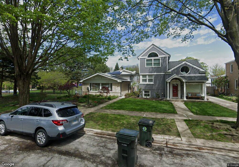
5714 Crain St Morton Grove, IL 60053
Estimated Value: $471,624 - $516,000
3
Beds
2
Baths
1,697
Sq Ft
$293/Sq Ft
Est. Value
About This Home
This home is located at 5714 Crain St, Morton Grove, IL 60053 and is currently estimated at $497,656, approximately $293 per square foot. 5714 Crain St is a home located in Cook County with nearby schools including Park View Elementary School, Niles West High School, and Arie Crown Hebrew Day School.
Ownership History
Date
Name
Owned For
Owner Type
Purchase Details
Closed on
Feb 12, 2002
Sold by
Kanev Leo
Bought by
Kanevsky Gina and Kanev Leo
Current Estimated Value
Purchase Details
Closed on
Jan 8, 2002
Sold by
Kanevsky Val and Kanevsky Gina
Bought by
Kanev Leo
Purchase Details
Closed on
Jun 6, 1994
Sold by
Flores M Olga
Bought by
Kanevsky Valery and Kanevsky Yevgenya
Home Financials for this Owner
Home Financials are based on the most recent Mortgage that was taken out on this home.
Original Mortgage
$130,400
Interest Rate
8.58%
Create a Home Valuation Report for This Property
The Home Valuation Report is an in-depth analysis detailing your home's value as well as a comparison with similar homes in the area
Home Values in the Area
Average Home Value in this Area
Purchase History
| Date | Buyer | Sale Price | Title Company |
|---|---|---|---|
| Kanevsky Gina | -- | -- | |
| Kanev Leo | -- | -- | |
| Kanevsky Valery | $163,000 | -- |
Source: Public Records
Mortgage History
| Date | Status | Borrower | Loan Amount |
|---|---|---|---|
| Previous Owner | Kanevsky Valery | $130,400 |
Source: Public Records
Tax History Compared to Growth
Tax History
| Year | Tax Paid | Tax Assessment Tax Assessment Total Assessment is a certain percentage of the fair market value that is determined by local assessors to be the total taxable value of land and additions on the property. | Land | Improvement |
|---|---|---|---|---|
| 2024 | $4,347 | $39,000 | $5,642 | $33,358 |
| 2023 | $4,273 | $39,000 | $5,642 | $33,358 |
| 2022 | $4,273 | $39,000 | $5,642 | $33,358 |
| 2021 | $4,849 | $31,192 | $3,472 | $27,720 |
| 2020 | $4,396 | $31,192 | $3,472 | $27,720 |
| 2019 | $4,358 | $35,048 | $3,472 | $31,576 |
| 2018 | $4,920 | $29,589 | $3,146 | $26,443 |
| 2017 | $4,870 | $29,589 | $3,146 | $26,443 |
| 2016 | $7,584 | $29,589 | $3,146 | $26,443 |
| 2015 | $6,206 | $23,755 | $2,712 | $21,043 |
| 2014 | $6,230 | $23,755 | $2,712 | $21,043 |
| 2013 | $6,054 | $23,755 | $2,712 | $21,043 |
Source: Public Records
Map
Nearby Homes
- 8708 Central Ave
- 8841 Menard Ave
- 8836 Mansfield Ave
- 8918 Parkside Ave
- 5536 Greenwood St
- 8655 Harms Rd
- 5510 Lincoln Ave Unit B301
- 5510 Lincoln Ave Unit B101
- 5506 Lincoln Ave Unit A117
- 5506 Lincoln Ave Unit A211
- 5506 Lincoln Ave Unit A216
- 8541 Lotus Ave Unit 914
- 5500 Lincoln Ave Unit 407W
- 5500 Lincoln Ave Unit 116E
- 5500 Lincoln Ave Unit 109W
- 5501 Lincoln Ave Unit 203
- 8849 Mcvicker Ave
- 6020 Lincoln Ave Unit 407
- 5352 Greenwood St
- 5309 Crain St
- 5712 Crain St
- 5706 Crain St
- 5706 Crain St
- 5704 Crain St
- 5715 Carol Ave
- 5707 Carol Ave
- 5707 Carol Ave
- 8700 Major Ave
- 5717 Crain St
- 5705 Carol Ave
- 5713 Crain St
- 5707 Crain St
- 5701 Carol Ave
- 8646 Major Ave
- 5646 Crain St
- 8717 Major Ave
- 5716 Capulina Ave
- 5714 Carol Ave
- 5710 Capulina Ave
- 5706 Capulina Ave