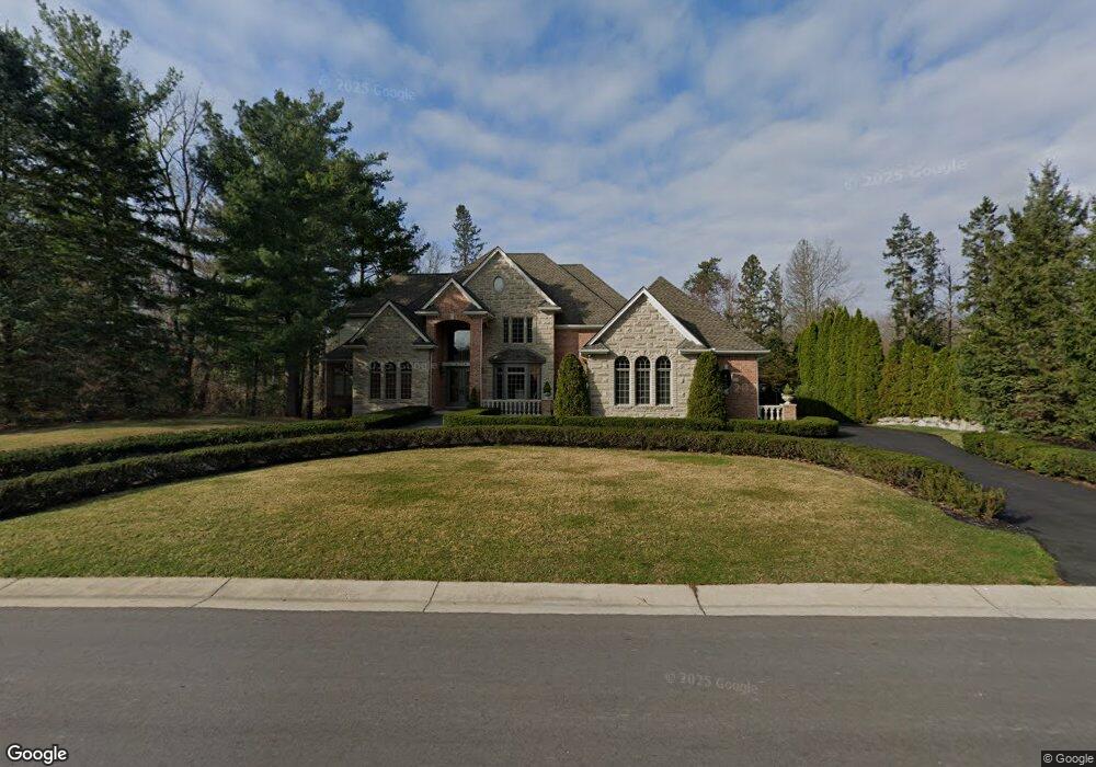
5714 Wyndam Ln Brighton, MI 48116
Estimated Value: $795,000 - $1,189,000
4
Beds
5
Baths
3,761
Sq Ft
$273/Sq Ft
Est. Value
About This Home
This home is located at 5714 Wyndam Ln, Brighton, MI 48116 and is currently estimated at $1,026,087, approximately $272 per square foot. 5714 Wyndam Ln is a home located in Livingston County with nearby schools including Hornung Elementary School, Scranton Middle School, and Brighton High School.
Ownership History
Date
Name
Owned For
Owner Type
Purchase Details
Closed on
Sep 29, 2000
Sold by
Livingston Development Group Inc
Bought by
Henwood Gregory J and Henwood Cynthia R
Current Estimated Value
Home Financials for this Owner
Home Financials are based on the most recent Mortgage that was taken out on this home.
Original Mortgage
$479,000
Outstanding Balance
$174,436
Interest Rate
7.9%
Estimated Equity
$851,651
Purchase Details
Closed on
Jun 17, 1999
Sold by
River Place/Abbey Ltd Partnership
Bought by
Livingston Development Group
Create a Home Valuation Report for This Property
The Home Valuation Report is an in-depth analysis detailing your home's value as well as a comparison with similar homes in the area
Home Values in the Area
Average Home Value in this Area
Purchase History
| Date | Buyer | Sale Price | Title Company |
|---|---|---|---|
| Henwood Gregory J | $164,301 | American Title Co | |
| Livingston Development Group | -- | Metropolitan Title Company |
Source: Public Records
Mortgage History
| Date | Status | Borrower | Loan Amount |
|---|---|---|---|
| Open | Henwood Gregory J | $479,000 |
Source: Public Records
Tax History Compared to Growth
Tax History
| Year | Tax Paid | Tax Assessment Tax Assessment Total Assessment is a certain percentage of the fair market value that is determined by local assessors to be the total taxable value of land and additions on the property. | Land | Improvement |
|---|---|---|---|---|
| 2025 | $9,714 | $461,400 | $0 | $0 |
| 2024 | $4,703 | $455,500 | $0 | $0 |
| 2023 | $4,495 | $436,000 | $0 | $0 |
| 2022 | $7,850 | $329,200 | $0 | $0 |
| 2021 | $7,534 | $347,100 | $0 | $0 |
| 2020 | $7,641 | $342,000 | $0 | $0 |
| 2019 | $7,527 | $329,200 | $0 | $0 |
| 2018 | $7,099 | $321,000 | $0 | $0 |
| 2017 | $6,965 | $321,000 | $0 | $0 |
| 2016 | $6,946 | $315,700 | $0 | $0 |
| 2014 | $5,849 | $287,700 | $0 | $0 |
| 2012 | $5,849 | $267,600 | $0 | $0 |
Source: Public Records
Map
Nearby Homes
- 5643 Wyndam Ln
- Lot 242-243 Hartford Way
- 5971 Barclay Dr
- 5876 Wyndam Ln
- 58 Wyndam Ln
- 55 Wyndam Ln
- 53 Pinemont Dr
- 15 Wyndam Ln
- 5972 Wyndam Ln
- 21 Rexford Ct
- 44 Pinemont Dr
- 36 Pinemont Dr
- 24 Rexford Ct
- 32 Pinemont Dr
- 43 Pinemont Dr
- 31 Pinemont Dr
- 25 Rexford Ct
- 5479 River Ridge Dr
- Unit 23 Pine Creek B Rexford Ct
- 41 Pinemont Dr
- 5696 Wyndam Ln
- 5732 Wyndam Ln
- 5768 Wyndam Ln
- 5678 Wyndam Ln
- 7359 Forest Way
- 5660 Wyndam Ln
- 7348 Forest Way
- 0000 Wyndam Ln
- 000 Wyndam Ln
- 0 Wyndam Ln Unit 5374671
- 0 Wyndam Ln Unit 4971478
- 0 Wyndam Ln Unit 4971327
- 0 Wyndam Ln Unit 4971231
- 0 Wyndam Ln Unit 4970573
- 0 Wyndam Ln Unit 4970432
- 0 Wyndam Ln Unit 4970322
- 0 Wyndam Ln Unit 4968868
- 0 Wyndam Ln Unit 4968767
- 0 Wyndam Ln Unit 4968397
- 0 Wyndam Ln Unit 4968145