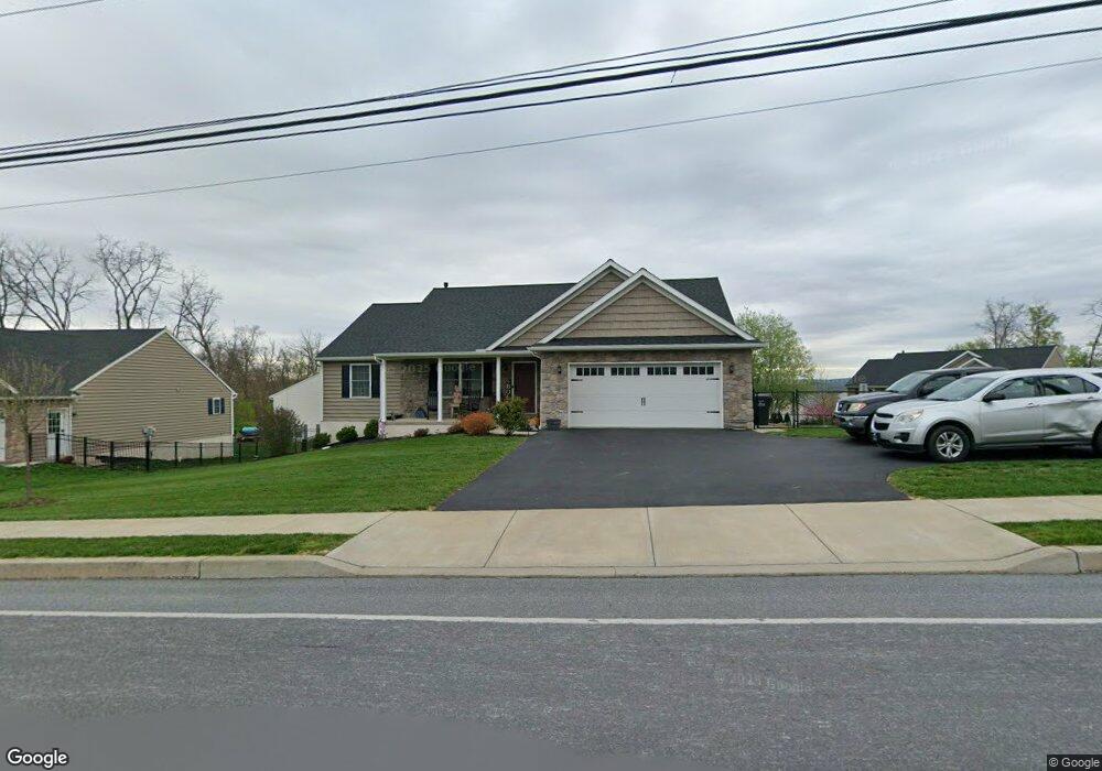
572 Red Run Rd East Earl, PA 17519
Estimated Value: $398,000 - $436,000
3
Beds
2
Baths
1,572
Sq Ft
$268/Sq Ft
Est. Value
About This Home
This home is located at 572 Red Run Rd, East Earl, PA 17519 and is currently estimated at $420,854, approximately $267 per square foot. 572 Red Run Rd is a home located in Lancaster County with nearby schools including Garden Spot Middle School, Garden Spot Senior High School, and Shalom Mennonite School.
Ownership History
Date
Name
Owned For
Owner Type
Purchase Details
Closed on
Jan 27, 2020
Sold by
Wildflower Llc
Bought by
Boley Stephen A and Boley Jennifer L
Current Estimated Value
Home Financials for this Owner
Home Financials are based on the most recent Mortgage that was taken out on this home.
Original Mortgage
$161,700
Outstanding Balance
$111,753
Interest Rate
3.73%
Mortgage Type
New Conventional
Estimated Equity
$309,101
Create a Home Valuation Report for This Property
The Home Valuation Report is an in-depth analysis detailing your home's value as well as a comparison with similar homes in the area
Home Values in the Area
Average Home Value in this Area
Purchase History
| Date | Buyer | Sale Price | Title Company |
|---|---|---|---|
| Boley Stephen A | $299,900 | First Amer Abstract Of Pa |
Source: Public Records
Mortgage History
| Date | Status | Borrower | Loan Amount |
|---|---|---|---|
| Open | Boley Stephen A | $161,700 |
Source: Public Records
Tax History Compared to Growth
Tax History
| Year | Tax Paid | Tax Assessment Tax Assessment Total Assessment is a certain percentage of the fair market value that is determined by local assessors to be the total taxable value of land and additions on the property. | Land | Improvement |
|---|---|---|---|---|
| 2025 | $4,393 | $245,300 | $64,900 | $180,400 |
| 2024 | $4,393 | $245,300 | $64,900 | $180,400 |
| 2023 | $4,330 | $245,300 | $64,900 | $180,400 |
| 2022 | $4,283 | $245,300 | $64,900 | $180,400 |
| 2021 | $4,215 | $245,300 | $64,900 | $180,400 |
| 2020 | $1,005 | $58,500 | $58,500 | $0 |
| 2019 | $994 | $58,500 | $58,500 | $0 |
| 2018 | $1,449 | $58,500 | $58,500 | $0 |
| 2017 | $658 | $31,600 | $31,600 | $0 |
| 2016 | $658 | $31,600 | $31,600 | $0 |
| 2015 | $183 | $31,600 | $31,600 | $0 |
| 2014 | $455 | $31,600 | $31,600 | $0 |
Source: Public Records
Map
Nearby Homes
- 575 Red Run Rd
- 61 Gentle Dr
- 232 New St
- 420 Linden St
- 412 Linden St
- 200 E Main St
- 133 Millstone Dr
- 205 E Main St
- 111 Oatfield Dr
- 117 Hawk Valley Ln Unit 105
- 101 Hawk Valley Ln
- Westbrooke Plan at Hawk Valley Estates
- Callahan Plan at Hawk Valley Estates
- Silverbrooke Plan at Hawk Valley Estates
- Wesley Plan at Hawk Valley Estates
- Bridgemont Plan at Hawk Valley Estates
- Logan Plan at Hawk Valley Estates
- Brookfield Plan at Hawk Valley Estates
- Kingston Plan at Hawk Valley Estates
- Berkley Plan at Hawk Valley Estates
- 572 Red Run Rd Unit 2
- 574 Red Run Rd
- 574 Red Run Rd Unit 1
- 13 Wild Rose Dr
- 572 Wildflower Dr Unit 2
- 570 Wildflower Dr
- 317 Wild Rose Dr
- 570 Wildflower Dr Unit 3
- 287 Wildflower Dr
- 0 Wildflower Dr Unit 149647
- 0 Wildflower Dr Unit 149727
- 00 Wildflower Dr
- 36 Wildflower Dr
- 38 Wildflower Dr
- 570 Red Run Rd
- 570 Red Run Rd Unit 3
- 573 Red Run Rd
- 207 Red Fern Dr
- 302 Wildflower Dr
- 285 Wildflower Dr